- Blakedown
-
Coordinates: 52°24′13″N 2°10′43″W / 52.403571°N 2.178555°W
Blakedown 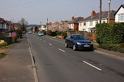
Belbroughton Road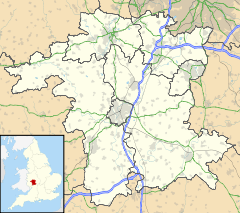
 Blakedown
Blakedown shown within WorcestershirePopulation 1,556 [1] OS grid reference SO879784 - London 108 miles (174 km) Parish Churchill and Blakedown District Wyre Forest Shire county Worcestershire Region West Midlands Country England Sovereign state United Kingdom Post town KIDDERMINSTER Postcode district DY10 Dialling code 01562 Police West Mercia Fire Hereford and Worcester Ambulance West Midlands EU Parliament West Midlands List of places: UK • England • Worcestershire Blakedown is a village in the Wyre Forest District in the north of the county of Worcestershire, England. Due to its road and rail links it serves mainly as a dormitory village for Kidderminster, and the cities of Birmingham and Worcester. Originally part of Hagley Parish, it was transferred in 1888 to the small adjacent parish of Churchill, which became Churchill and Blakedown.
Much of Blakedown was originally an area of common land, enclosed in the 19th century. However Harborough Hall, which once belonged to the family of William Shenstone the poet, is probably the successor of a house that goes back to Medieval times.
The main road that runs through the village was part of the turnpike road from Birmingham to Kidderminster. The turnpike trust was established in 1753.
Blakedown railway station was opened in 1852 and originally called Churchill station). Later it was called Churchill and Blakedown before adopting its current name.
The village has a small church, St. James the Great, and a Church of England primary school. Blakedown also includes two local pubs, and a village shop that offers a range of fresh foods and a newspaper delivery service.
References
- ^ 2001 Census census
External links
Towns Villages Areley Kings • Astley Cross • Axborough • Blakedown • Blakeshall • Bliss Gate • Broome • Caunsall • Chaddesley Corbett • Churchill • Clows Top • Cookley • Drayton • Franche • Heightington • Kingsford • Ribbesford • Rock • Rushock • Shenstone • Stone • Tanwood • Upper Arley • WolverleyCivil parishes Categories:- Villages in Worcestershire
- Worcestershire
- Worcestershire geography stubs


Wikimedia Foundation. 2010.