- Denfert-Rochereau (Paris Métro and RER)
-
Denfert-Rochereau Date opened 24 April 1906 Accesses 2, pl. Denfert-Rochereau
3, pl. Denfert-Rochereau
1, av. du Général Leclerc
2, av. du Général Leclerc
4, av. du Général LeclercMunicipality/
Arrondissementthe 14th arrondissement of Paris Fare zone 1 Next stations Paris Métro Line 4 Direction
Porte de ClignancourtDirection
Porte d'OrléansRaspail Mouton-Duvernet Paris Métro Line 6 Direction
Charles de Gaulle – ÉtoileDirection
NationRaspail Saint-Jacques List of stations of the Paris Métro 
 Location of metro station
Denfert-Rochereau is a station on the Paris Métro and RER systems, in France.
The RER station was previously a terminus of the Ligne de Sceaux, a surface suburban railway. It was rebuilt as an underground station, though the original station building survives and has been restored. The station opened on 24 April 1906 with the opening of the extension of line 2 Sud from Passy to Place d'Italie. On 14 October 1907 line 2 Sud became part of line 5. On 12 October 1942 the section of line 5 between Étoile and Place d'Italie, including Denfert-Rochereau, was transferred from line 5 to line 6 in order to separate the underground and elevated sections of the metro (because the latter were more vulnerable to air attack during World War II). The line 4 platforms were opened on 30 October 1909 when the southern section of line 4 was opened between Raspail and Porte d'Orléans.
Its name refers to Place Denfert-Rochereau, named for the 19th‑century general Pierre Philippe Denfert-Rochereau, who led the resistance of Belfort to a siege during the Franco-Prussian War. The first part of the name is identical in pronunciation to its former name of Place d'Enfer ("Place of Hell"). It is the location of the Barrière d'Enfer, a gate built for the collection of taxation as part of the Wall of the Farmers-General; the gate was built between 1784 and 1788 and is one of only four of the 55 gates with any surviving remains.[1][2]
Contents
Gallery
Métro
RER
-
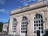
Gare de Denfert-Rochereau building
-

RER B platforms at Denfert-Rochereau
-

View to north from RER platforms
-

View to south from RER platforms
References
- ^ "Barrière d'Enfer, picture" (in French). Bibliothèque nationale de France. http://gallica.bnf.fr/ark:/12148/btv1b7743673k.item.f1.langFR. Retrieved 16 October 2009.
- ^ "Barrière de Montreuil" (in French). Bibliothèque nationale de France. http://gallica.bnf.fr/ark:/12148/bpt6k208539k.image.f252.langFR. Retrieved 16 October 2009.
Preceding station RER Following station toward Aéroport Charles de Gaulle 2 – TGV or Mitry - Claye
 toward Robinson or Saint-Rémy-lès-Chevreuse
Paris Métro Line 4 Porte de Clignancourt • Simplon • Marcadet — Poissonniers

 • Château Rouge • Barbès — Rochechouart
  • Gare du Nord


 • Gare de l'Est
  • Château d'Eau • Strasbourg — Saint-Denis
 • Réaumur — Sébastopol
  • Étienne Marcel • Les Halles ⇒
  • Châtelet

 • Cité • Saint-Michel ⇒
  • Odéon
  • Saint-Germain-des-Prés • Saint-Sulpice • Saint-Placide • Montparnasse — Bienvenüe
 • Vavin • Raspail • Denfert-Rochereau • Mouton-Duvernet • Alésia • Porte d'Orléans

Paris Métro Line 6 Charles de Gaulle — Étoile
• Kléber • Boissière • Trocadéro • Passy • Bir-Hakeim • Dupleix • La Motte-Picquet — Grenelle • Cambronne • Sèvres — Lecourbe • Pasteur • Montparnasse — Bienvenüe  • Edgar Quinet • Raspail • Denfert-Rochereau • Saint-Jacques • Glacière • Corvisart • Place d'Italie • Nationale • Chevaleret • Quai de la Gare • Bercy • Dugommier • Daumesnil • Bel-Air • Picpus • Nation
Coordinates: 48°50′02″N 2°19′58″E / 48.833901°N 2.332728°EParis rail stations Termini Paris Saint Lazare • Paris Nord • Paris Est • Paris Lyon • Paris Bercy • Paris Austerlitz • Paris Montparnasse • Bastille • Invalides • Orsay
SNCF stations Pont CardinetRER stations Gare du Nord • Châtelet – Les Halles • St-Michel-Notre-Dame • Luxembourg • Port-Royal • Denfert-Rochereau • Cité UniversitairePorte de Clichy • Pereire – Levallois • Neuilly – Porte Maillot • Avenue Foch • Avenue Henri Martin • Boulainvilliers • Avenue du Président Kennedy • Pont du Garigliano • Javel • Champ de Mars - Tour Eiffel • Pont de l'Alma • Invalides • Musée d'Orsay • Saint-Michel-Notre-Dame • Gare d'Austerlitz • Bibliothèque François MitterrandGare du Nord • Châtelet – Les Halles • Gare de LyonClosed stations are in italics.
See also: List of stations of the Paris Métro, Tramways in Paris & Transport in Paris. There is also an external interactive map.Categories:- Paris Métro line 4
- Paris Métro line 6
- Paris Métro stations in the 14th arrondissement of Paris
- Railway stations opened in 1906
-


Wikimedia Foundation. 2010.