- Barnetby
-
Coordinates: 53°34′40″N 0°24′26″W / 53.5779°N 0.4071°W
Barnetby 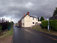
West Street, Barnetby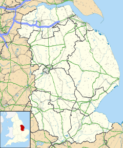
 Barnetby
Barnetby shown within LincolnshirePopulation 1,593 (2001 census) OS grid reference TA054102 Unitary authority North Lincolnshire Ceremonial county Lincolnshire Region Yorkshire and the Humber Country England Sovereign state United Kingdom Post town BARNETBY Postcode district DN38 Dialling code 01652 Police Humberside Fire Humberside Ambulance East Midlands EU Parliament Yorkshire and the Humber UK Parliament Brigg and Goole List of places: UK • England • Lincolnshire Barnetby (or Barnetby le Wold) is a village and civil parish in North Lincolnshire, England, between Scunthorpe and Grimsby. According to the 2001 census it had a population of 1,593. Barnetby railway station serves the village and surrounding area. The hamlet of Coskills is in Barnetby parish.
Contents
Overview
Despite being built up by the coming of the railway, the village has a long history. The village goes back over 1,000 years, and in the Domesday Book of 1086 the village appears as Bernodebi - which derives from the Scandinavian name "Beornnoth". The redundant Church of St Mary on Church Hill is originally of Saxon origin, but the recent building contains more Norman architecture. The font inside the church is said[by whom?] to date from the times of King Stephen. On the northern side of the church a crude carving of a cat may be seen. St Mary's Church originally possessed a Norman lead font, which was the only one in Lincolnshire - being only 30 such examples in England. The font was moved to the newer church of St Barnabas and is now in the North Lincolnshire Museum, Scunthorpe. Despite being called "new", St Barnabas Church was completed in 1927, and is of brick construction. For many years the church hall was of wooden construction, but this was demolished and a modern brick hall built on the site. The church hall was the main venue for many village functions until a purpose built village hall was built during the 1980s alongside the playing fields. The other religious building in Barnetby is the Methodist Chapel and Hall on West Street.
Another building is the old maltings alongside the railway. Long disused, this building is steadily crumbling away and many[who?] consider it to be an eyesore. Several years ago,[when?] the maltings caught fire.
The Viking Way passes through Barnetby as it makes its way from the River Humber to Oakham, in Rutland. The route is posted with a Viking symbol.
Just outside the village and alongside the A18 Brigg road is a set of gallows apparently[vague] dating from the 17th Century. It is not certain if these were the original gallows.[vague] The purpose of the gallows was to act as a deterrent to the two feuding families of the de Ros (of Melton Ross and the Tyrwhits of Kettleby. This feud had been going on for almost 300 years until James I ordered that a set of gallows be erected at the present location, with the instruction that any more deaths as a result of this feud be treated as murder and punishable by hanging.
The village has two pubs. Originally both with railway connections the one nearest the train station used to be called the Station Hotel. Redevelopment of the hotel to include accommodation and a music studio resulted in the pub being renamed the "Whistle & Flute". The other pub is still called the Railway Inn and is located a short walk[vague] away from the railway station.
Railway
The village as it stands today is a direct result of the coming of the railway in 1848. Originally part of the Trent, Axholme & Grimsby Railway, it later passed into the hands of the Manchester, Sheffield & Lincolnshire Railway, thereafter becoming part of the Great Central Railway. In the 1923 grouping of railway companies the Great Central became the London & North Eastern Railway and finally in 1948 becoming British Railways before becoming Railtrack and ultimately the present-day Network Rail.
Although Barnetby had a small amount of rail freight traffic originating from it, most of the trains were passing through on the way to Immingham or Grimsby. In the other direction, freight trains such as the "Banbury fish" passed through. However, most of Barnetby's rail traffic was involved with the steel works at Scunthorpe, which was taken over by Corus. Although Lincolnshire has a reputation for being flat, this part of the county has several steep inclines and many freights required extra locomotives in order to cope with the gradients. For this purpose, a locomotive depot was built at nearby Wrawby junction - together with a turntable. Today, all that is left of the depot is the remains of the turntable pit which can just be seen in the undergrowth between the Brigg and Lincoln branch lines.
Although Barnetby's rail network has been significant rationalised, 21st Century Barnetby is still very busy. Almost 25 per cent of the Britain's bulk rail freight traffic passes through the village. The biggest volume is the imported coal to feed power stations and the nearby Corus steelworks at Scunthorpe. Iron Ore, petroleum products and steel also pass through in large quantities.
Bus service
Stagecoach in Lincolnshire provide two daily buses to the village on weekdays. The local Unitary Authority of North Lincolnshire Council introduced the "Wolds Villager" which runs between Brigg Leisure Centre and Barnetby.
Airport
Humberside International Airport is 4 miles away with flights to Amsterdam, Dublin and holiday destinations. An oil platform helicopter ferry operator is based at the airport as is the Humberside Police helicopter which has been recently[when?] stationed there.
External links
 Media related to Barnetby at Wikimedia CommonsCategories:
- Villages in Lincolnshire
- Civil parishes in Lincolnshire


Wikimedia Foundation. 2010.