- Broadhembury
-
Coordinates: 50°50′08″N 3°16′39″W / 50.835556°N 3.2775°W
Broadhembury 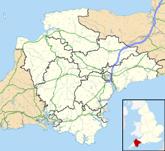
 Broadhembury
Broadhembury shown within DevonPopulation 654 (2001 Census) Parish Broadhembury District East Devon Shire county Devon Region South West Country England Sovereign state United Kingdom Police Devon and Cornwall Fire Devon and Somerset Ambulance South Western EU Parliament South West England List of places: UK • England • Devon Broadhembury is a village and civil parish in the East Devon district of Devon, England, about 5 miles north-west of Honiton.
According to the 2001 census the village had a population of 654. It is within the Blackdown Hills Area of Outstanding Natural Beauty.
History
 Broadhembury, seen from the west.
 Church.
Broadhembury is set in the centre of a horse shoe of the hills of Hembury Fort and North Hill, which rise to 1000 feet and create a sheltered, beautiful valley.
Hembury Fort, a prehistoric hill fort dating from 3000BCE that was also used by the Romans. After the departure of the Romans this area of Devon was sparsely occupied by the Celtic people. In these years Hembury Fort was called Handria. With the arrival of the Saxons little wattle churches were built and the villagers lived in little cells or wooden huts. The Saxons brought the plough and cultivated the holdings. At the time of the Norman conquest of England in 1066, the population density of Broadhembury was 9 per square mile. During the Black Death of 1364, the population was affected, with 2 priests dying of it.
Henry VIII presented the land at Broadhembury to his faithful courtier, Thomas Wriothesley, Earl of Southampton, who sold it Sir Thomas Drewe, son of Edward Drewe. Edward Drewe was responsible for the building of the Manor house adjoing a small farm house at Grange in about 1603. Edward was a Sergeant at arms to Queen Elizabeth.
Broadhembury has changed very little in outward appearance during the last century, with many of the thatch and cob cottages standing since the 16th century.
Julius Drewe purchased the inn, and half the village at the turn of the 20th century. Broadhembury House, the large thatched residence on the North side of the church, was converted by him from an old cottage. The Garden, which is of particular beauty, is open on summer weekends to the public.
The descendants of Julius Drewe of Castle Drogo, Drewsteignton, still live in the village in Broadhembury House. It is thanks to Sir Cedric Drewe, who was a Member of Parliament for many years that the village has kept its excellent character over the years.
People
Augustus Montague Toplady became the vicar in 1768.
Charles Buller Heberden, Principal of Brasenose College, Oxford and Vice-Chancellor of Oxford University, was born in the village on 14 May 1849.
Kirstie Allsopp host of Location, Location, Location has a home in Broadhembury.
External links
Towns, villages and hamlets in the East Devon District of Devon, England 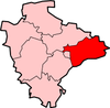 Alfington · Axminster · Beacon · Beer · Bowd · Branscombe · Broadhembury · Buckerell · Budleigh Salterton · Church Green · Colyford · Colyton · Combpyne · Exmouth · Farway · Feniton · Honiton · Kilmington · Marsh Green · Membury · Musbury · Northleigh · Offwell · Ottery St Mary · Pinhay · Rousdon · Salcombe Regis · Seaton · Shute · Sidford · Sidmouth · Smallridge · Southleigh · Stockland · Street · Uplyme · Ware · West Hill · Weston · WhitfordCategories:
- Villages in Devon
- Devon geography stubs


Wikimedia Foundation. 2010.