- Orakei Train Station
-
Orakei Train Station
MAXX Urban rail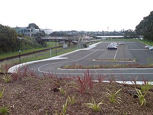
The station in 2008, looking westwards.Station statistics Address Orakei Road,
Orakei,
AucklandCoordinates 36°51′45″S 174°48′34″E / 36.862426°S 174.809553°E Lines Eastern Line Levels 1 Platforms Island platform Tracks Mainline (2) Parking Yes Bicycle facilities No Baggage check No Other information Opened 1930 Electrified No Owned by ONTRACK and ARTA Traffic Passengers (2009) 761 passengers/day Services ONTRACK Preceding station MAXX (Veolia) Following station TerminusEastern Line toward PukekoheOrakei Train Station in the Auckland suburb of Orakei is located on the Eastern Line of the Auckland railway network. It has an island platform layout and can be reached by an overbridge from Orakei Road. It is backed by a carpark and a shopping complex.
Overview
The Redwood development group is currently (2008) planning to redevelop the area around the train station substantially. A plan with several skyscraper-style apartment buildings (and in turn providing substantial green space and waterfront access to the public) did meet with substantial local protest. A more scaled-back plan was then proposed which limits the buildings to six storeys and is currently being discussed. It would retain public access and amenities, and also provide a covered new train station.[1]
References
- ^ Borley, Craig (10 October 2008). "Developer scales down Orakei plan". The New Zealand Herald. http://www.nzherald.co.nz/nz/news/article.cfm?c_id=1&objectid=10536739. Retrieved 1 November 2011.
Railway stations on the Eastern Line, Auckland (Full List) Britomart • Orakei • Meadowbank • Glen Innes • Panmure • Sylvia Park • Westfield • Otahuhu • Mangere • Middlemore • Papatoetoe • Puhinui • Homai • Manurewa • Te Mahia • Takanini • Papakura • PukekoheCategories:- Rail transport in Auckland
- Railway stations in New Zealand
- Railway stations opened in 1930
- New Zealand rail transport stubs

Wikimedia Foundation. 2010.