Seneca Rocks, West Virginia

Seneca Rocks, West Virginia
Seneca Rocks
—  Unincorporated community  —
Community of Seneca Rocks, West Virginia at the confluence of Seneca Creek and the North Fork South Branch Potomac River. The "Seneca Rocks Discovery Center" is at the center of the photo which was taken from atop Seneca Rocks.
Seneca Rocks is located in West Virginia
Seneca Rocks
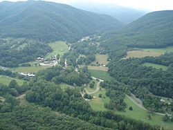
Location within the state of West Virginia
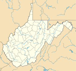
Coordinates: 38°50′5″N 79°22′34″W / 38.83472°N 79.37611°W / 38.83472; -79.37611Coordinates: 38°50′5″N 79°22′34″W / 38.83472°N 79.37611°W / 38.83472; -79.37611
Country United States
State West Virginia
County Pendleton
Time zone Eastern (EST) (UTC-5)
 – Summer (DST) EDT (UTC-4)
ZIP codes
FIPS code
GNIS feature ID

Seneca Rocks is an unincorporated community located in Pendleton County, West Virginia, USA. The community of Seneca Rocks — formerly known as Mouth of Seneca — lies along West Virginia Route 28/West Virginia Route 55 near the confluence of Seneca Creek and the North Fork South Branch Potomac River. The community also lies near Seneca Rocks, the crag from which it takes its name. Both lie within the Spruce Knob-Seneca Rocks National Recreation Area of the Monongahela National Forest.

Located at Seneca Rocks is the Sites Homestead, now known as the Seneca Rocks Visitor Center, listed on the National Register of Historic Places in 2004.[1] Located nearby is the Boggs Mill, listed in 2004.[1]


References


Wikimedia Foundation. 2010.

Игры ⚽ Нужна курсовая?

Look at other dictionaries:

  • Seneca Rocks — Seneca Rocks, formerly the Cliffs of Seneca , is a large crag and local landmark in Pendleton County in the Eastern Panhandle of West Virginia, USA. It is easily visible and accessible along West Virginia Route 28 in the Spruce Knob Seneca Rocks… …   Wikipedia

  • Spruce Knob-Seneca Rocks National Recreation Area — Geobox|Protected Area name = Spruce Knob Seneca Rocks National Recreation Area native name = other name = Part of Monongahela National Forest other name1 = category = National Recreation Area category iucn = image caption = Seneca Rocks etymology …   Wikipedia

  • U.S. Route 48 in West Virginia — The U.S. Route 48 designation has not yet been applied in West Virginia due to major segments of highway either under construction or under planning. The designation will follow Corridor H from Interstate 79 in Weston eastward to Virginia.West… …   Wikipedia

  • West Virginia Route 28 — Infobox road state=WV type=WV route=28 length mi=150.8 length round=1 length ref=Distance calculated using Microsoft MapPoint mapping software.] established= direction a=South starting terminus= junction=jct|state=WV|WV|92 concurrent Dunmore to… …   Wikipedia

  • West Virginia Route 55 — Infobox road state=WV type=WV route=55 length mi=227.9 length round=1 length ref=Distance calculated using Microsoft MapPoint mapping software.] established= direction a=West starting terminus= junction=jct|state=WV|WV|20 from Craigsville to… …   Wikipedia

  • West Virginia Maneuver Area — The West Virginia Maneuver Area (WVMA) was a vast, five county training ground in the Allegheny Mountains of eastern West Virginia used by the U.S. Army during World War II to train soldiers in low altitude mountain operations. This area was… …   Wikipedia

  • West Virginia — This article is about the U.S. state of West Virginia. For other uses, see West Virginia (disambiguation). State of West Virginia …   Wikipedia

  • West Virginia Prehistory — The area now known as West Virginia was a favorite hunting ground of numerous Native American peoples before the arrival of European settlers. Many ancient man made earthen mounds from various mound builder cultures survive, especially in the… …   Wikipedia

  • Seneca — may refer to: People* Seneca the Elder, Roman orator and writer * Seneca the Younger, son of Seneca the Elder, Roman philosopher and playwright, tutor and advisor of Nero * Seneca Wallace, American football quarterback/wide receiver currently… …   Wikipedia

  • River Knobs (West Virginia) — For other River Knobs , see River Knobs. Infobox Mountain Name = River Knobs (West Virginia) Photo = GermanyValley.wmg.jpg Caption = The River Knobs, seen in the middle distance beyond Germany Valley Elevation = 2,854 feet / 870 m (Harmon Knob)… …   Wikipedia

Share the article and excerpts

Direct link
Do a right-click on the link above
and select “Copy Link”