- Chausey
-
Chausey 
The Fort, Grande Île
 Chausey (France)
Geography Location English Channel Coordinates 48°52′13″N 1°49′21″W / 48.87028°N 1.8225°WCoordinates: 48°52′13″N 1°49′21″W / 48.87028°N 1.8225°W Major islands Grande Île Country FranceRegion Basse-Normandie Department Manche Commune Granville Demographics Population 30 (as of 1999) Chausey is a group of small islands, islets and rocks off the coast of Normandy, in the English Channel. It lies 17 kilometres (11 mi) from Granville, and forms a quartier of the Granville commune, in the Manche département. Chausey forms part of the Channel Islands from a geographical point of view, but because it is under French jurisdiction it is almost never mentioned in the context of the other Channel Islands. There are no scheduled transport links between Chausey and the other Channel Islands, although between two and four daily shuttles link Chausey to mainland France, depending on the season.
The -ey ending of the name Chausey may be assumed to be associated with the Norse -ey (meaning island) seen in Jersey, Guernsey and Alderney.
Contents
History
In 933, the Duchy of Normandy annexed the Channel Islands including Chausey, Minquiers and Ecrehos. In 1022, Richard II, Duke of Normandy, gave Chausey and the barony of Saint-Pair-sur-Mer, to the Benedictine monks of Mont Saint-Michel, who built a priory on the Grande île.[1]
The Islands became subject to the Kingdom of England following the conquest of England by William, Duke of Normandy in 1066. However, in 1202, in a conflict with King John, Philip Augustus of France, claiming feudal overlordship of Normandy, summoned the English King to answer charges or forfeit all lands which he held in fee of the King of France. John refused to appear and, in 1204, Philip occupied continental Normandy although he failed in his attempts to occupy the islands in the Channel. The 1259 Treaty of Paris confirmed the loss of Normandy but the retention of the "islands (if any) which the King of England should hold" under Suzerainty of the King of France.[2] The vassalage requirement was extinguished in the Treaty of Calais of 1360.[3]
Chausey was for a long time an object of rivalry between England and France. Although the United Kingdom Government has contended that, until about 1764, Chausey belonged to England,[4] Chausey, unlike its Channel Islands neighbours, has, in fact, been French for centuries. It was administered from Jersey until 1499, when it was abandoned to the French for reasons unknown. The Jersey historian Alec Podger has suggested that it was too costly in terms of money and manpower to control and, as the Islands were not on the sea-lanes, it was decided that this cost was not justified by the benefits.[5] As a site of piracy and smuggling, this maze of islands was for a long time a den valued by seafarers engaged in illegal business. The Sound, the natural channel running along the Grande île, or the Passe Beauchamp, were ideally secluded anchorages.
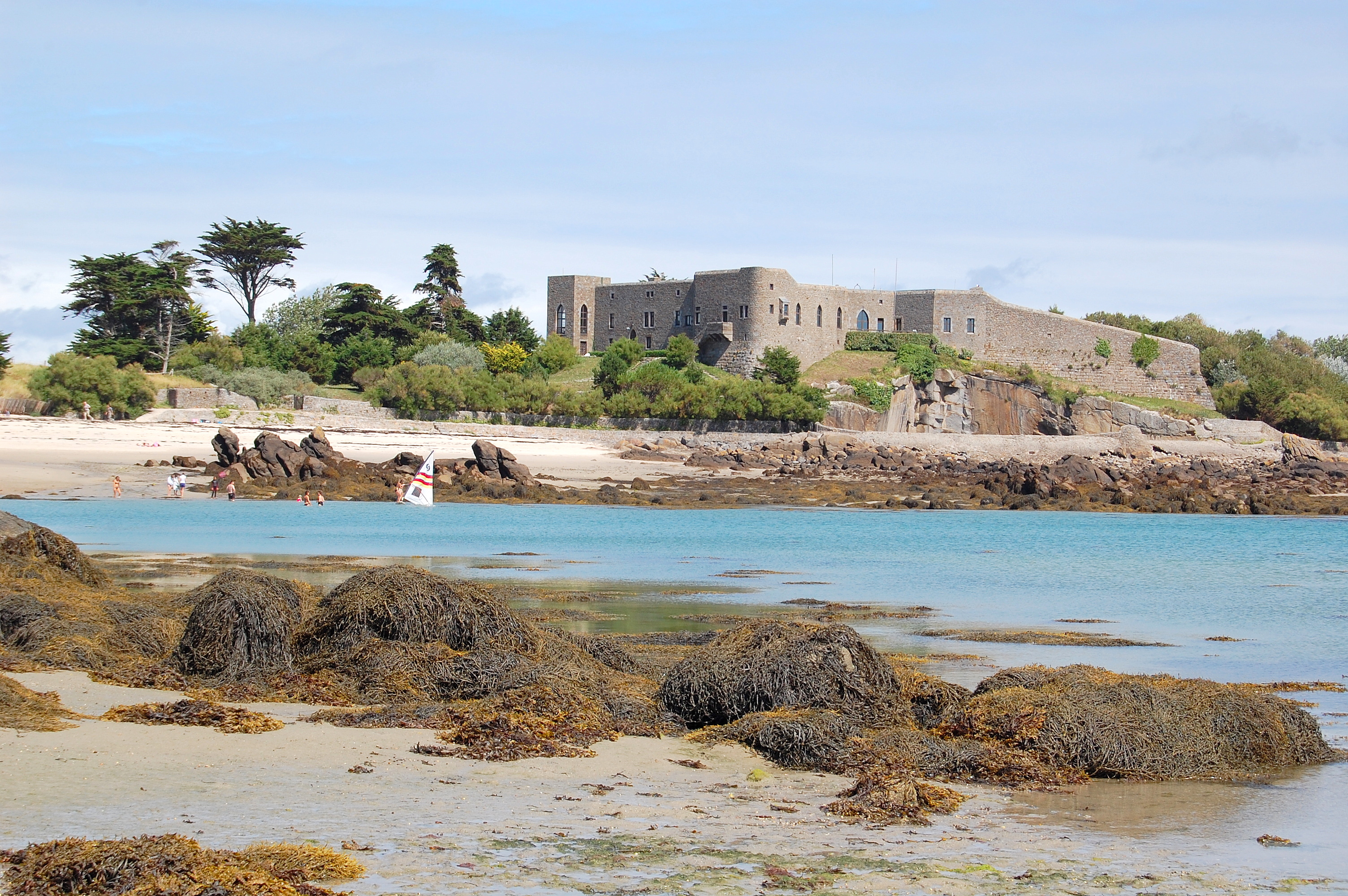
The fortress of Matignon was built in the mid-16th century, and was a quadrangular fort with a round tower, cellars, a bakery, and a cattle shed. This was expanded in 1740, and is today known as Château Renault, after the automobile engineer Louis Renault who purchased it and restored it in the early 20th century. This fortress, however, was not considered sufficient to repel potential British invasions, and so Napoleon III ordered the construction of the present fort in 1859. It was complete by 1866, but ceased to be a military site in 1906. It was used to shelter 300 German and Austrian prisoners of war during the First World War, and was garrisoned by German soldiers during the Second World War. Today the fort serves as the homes of several fishermen.[6]
Geography
Grande Île, the main island, is 1.5 kilometres (0.93 mi) long and 0.5 kilometres (0.31 mi) wide at its widest (approximately 45 hectares (110 acres)), though this is just the tip of a substantial and complex archipelago which is exposed at low tide. The archipelago comprises 365 islands at low tide, compared to only 52 islands at high tide. From a few dozen hectares of ground above the high tide line, the archipelago increases to around 2,000 hectares (4,900 acres) at low water, within an area roughly 6.5 by 12 kilometres (4.0 by 7.5 mi).[7] The tidal range is one of the largest in Europe, with up to 14 metres (46 ft) difference between low and high tide.[citation needed] The islands consist of a granitic geological formation, which has been subjected to erosion by sea and wind. Sandbars connect several parts of Chausey.
 Boats in Chausey Sound. The two-master on the right is a traditional type known as a Bisquine.
Grand Île is the only inhabited island of the group, with a population of around 30. In summer the population increases, due to the tourism which constitutes an essential activity on the island, with nearly 200,000 annual visitors.[7] Several tourist businesses operate on the island, including a hotel, restaurant and shop. Besides tourism, fishing is the main economic activity. Lobster, shrimp, conger, bass and mullet are caught, while mussels and oysters are farmed. Until 1989, a cattle farm operated on the island.[7] The island's granite was formerly quarried, and the stone exported. Chausey stone was used in the construction of Mont Saint Michel.
The typical boats of Chausey are the doris (dory), a flat-bottomed boat traditionally propelled by oars or nowadays an engine, used by the fishermen, and the canot chausiais, a small clinker-built sailing boat used for pleasure. Every August, the Chausey Regatta takes place on the first weekend of the neap tide. The festivities last all weekend, during which several boat races are organized.
References
- ^ D'après Jacques Doris,Les îles Chausey, Coutances imprimerie, 1929.Disponible sur Normannia
- ^ Summaries of Judgments, Advisory Opinions and Orders of the International Court of Justice: Minquiers and Ecrehos Case Judgment of 17 November 1953
- ^ p118, Hersch Lauterpacht, "Volume 20 of International Law Reports, Cambridge University Press, 1957, ISBN 0-521-46365-3
- ^ Lauterpacht
- ^ Podger, Alec. Jersey: "That Nest of Vypers"
- ^ "La Grande Ile". Les Iles Chausey. http://www.ileschausey.com/textes/grandeile/grandeile.htm. Retrieved 2009-07-24.
- ^ a b c Chausey Islands 2008 official brochure (French language)
External links
Categories:- Islands of France
- Islands of Normandy
- Islands of the Channel Islands
- Archipelagoes of the Atlantic Ocean
- Manche


Wikimedia Foundation. 2010.