- Minnesota State Highway 74
-
Trunk Highway 74
Route information Defined by MS § 161.115(5) Maintained by Mn/DOT Length: 34.956 mi[1] (56.256 km) Existed: 1933 – present Major junctions South end: 
 U.S. 52 / MN 30 at Chatfield
 I-90 near St. Charles
 U.S. 14 at St. Charles
North end:  U.S. 61 at Weaver
Location Counties: Fillmore, Olmsted, Winona, Wabasha Highway system Minnesota Trunk Highways
Interstate • U.S. • State
Inter-County • County roads • Legislative routes←  MN 73
MN 73US 75  →
→Minnesota State Highway 74 is a highway in southeast Minnesota, which runs from its intersection with U.S. Highway 52 and State Highway 30 in Chatfield and continues north to its northern terminus at its intersection with U.S. Highway 61 at Weaver along the Mississippi River.
It is the only remaining road in the state highway system which is still partially unpaved.
Highway 74 is 35 miles (56 km) in length.
Contents
Route description
State Highway 74 serves as a north–south route in southeast Minnesota between Chatfield, St. Charles, Elba, and Weaver.
Highway 74 begins at its intersection with U.S. 52 and State Highway 30 in Chatfield and continues north through the small unincorporated communities of Troy and Saratoga. Highway 74 has a junction with Interstate 90 just south of St. Charles. In St. Charles, Highway 74 becomes Main Street, also known as Whitewater Avenue, until it joins U.S. Highway 14 briefly. Highway 74 runs concurrent west with Highway 14 for less than a mile. The route continues north again, passing through Whitewater State Park and the small town of Elba.
7 miles (11 km) of the route near the northern end, in what is known as the Weaver Bottoms, are unpaved gravel. Highway 74 ends at its junction with U.S. Highway 61 in Weaver.
The route is legally defined as Legislative Route 74 in the Minnesota Statutes.[2]
History
Highway 74 was authorized in 1933. The south end of Highway 74 previously extended south of Chatfield to old U.S. Highway 16 at Spring Valley until 1974.[3] As a result of this, the present day mile markers begin at mile 20. Highway 74 follows, in part, an old route which was one of the first public roads in the Minnesota Territory.
In 1953, the route was still gravel south of U.S. Highway 14. Highway 74 was paved by 1960,[3] except for the northernmost 7 miles, which is still gravel in the present day.
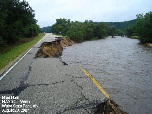
Flood
The 2007 Midwest flooding caused much damage to Highway 74. On August 18th and 19th, 2007, the flooded Whitewater River destroyed bridges and washed out the roadway in several places. By 2008, repairs were complete.
Images
-

The southern terminus of State Highway 74 in Chatfield
-

At the northern end of the unpaved portion of Highway 74, near Weaver
-
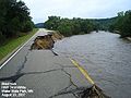
Highway 74 during the 2007 flood
-
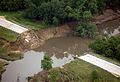
Aerial view of Highway 74 after the 2007 flood
Major intersections
County Location Mile[1] Destinations Notes Fillmore Chatfield 20.050 US 52 / MN 30West end of MN 30 overlap Olmsted Elmira Township 24.201 MN 30East end of MN 30 overlap Winona Saratoga Township 26.673 CR 6 St. Charles Township 32.263 CR 35 32.412-32.530 I-90Interchange St. Charles 33.834 US 14East end of US 14 overlap 34.090 US 14West end of US 14 overlap Elba Township 37.459 CR 22 41.781 CR 39 Elba 43.544 CR 26 Beaver 48.288 CR 30 Wabasha Weaver 55.393 US 611.000 mi = 1.609 km; 1.000 km = 0.621 mi
Concurrency terminus • Closed/Former • Incomplete access • UnopenedReferences
- ^ a b "Trunk Highway Log Point Listing - Construction District 6" (PDF). Minnesota Department of Transportation. August 23, 2010. http://www.dot.state.mn.us/roadway/data/reports/logpoint/d6.pdf. Retrieved October 29, 2010.
- ^ "161.115, Additional Trunk Highways". Minnesota Statutes. Office of the Revisor of Statutes, State of Minnesota. 2010. https://www.revisor.mn.gov/statutes/?id=161.115. Retrieved October 29, 2010.
- ^ a b Riner, Steve. "Details of routes 51-75". The Unofficial Minnesota Highways Page. http://www.steve-riner.com/mnhighways/r51-75.htm#74. Retrieved October 29, 2010.[unreliable source]
Categories:- State highways in Minnesota
-


Wikimedia Foundation. 2010.