- River Exe
Geobox River
name = River Exe
native_name =
other_name =
other_name1 =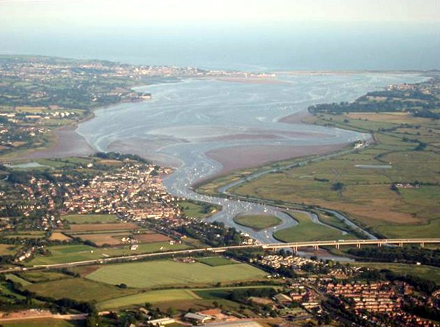
image_size =
image_caption = The Exe Estuary from a balloon over Exeter. The M5 motorway is in the foreground, Topsham on the left bank just beyond, and Exmouth at the river mouth.
country = England
state = Devon
state1 = Somerset
state_type = Counties
city = Exeter
length =
watershed =
discharge_location =
discharge_average =
discharge_max =
discharge_min =
discharge1_location =
discharge1_average =
source_name = Exe Head
source_location = nearSimonsbath
source_district =
source_region = Somerset
source_state =
source_country = England
source_lat_d = 51
source_lat_m = 09
source_lat_s = 33
source_lat_NS = N
source_long_d = 3
source_long_m = 47
source_long_s = 12
source_long_EW = W
source_elevation = 440
source_length =
mouth_name = Lyme Bay
mouth_location = English Channel
mouth_district =
mouth_region =
mouth_state =
mouth_country =
mouth_lat_d = 50
mouth_lat_m = 36
mouth_lat_s = 53
mouth_lat_NS = N
mouth_long_d = 3
mouth_long_m = 25
mouth_long_s = 30
mouth_long_EW = W
mouth_elevation = 0
tributary_left = River Haddeo
tributary_left1 =River Barle
tributary_left2 =River Creedy
tributary_right =River Hadden
tributary_right1 =River Culm
tributary_right2 = Clyst
free_name =
free_value =
map_size =
map_caption =The River Exe in
England rises near the village ofSimonsbath , onExmoor inSomerset , near theBristol Channel coast, but flows more or less directly due south, so that most of its length lies inDevon . It reaches the sea at a substantialria on the south (English Channel ) coast of Devon. Historically, its lowest bridging point was atExeter , though there is now a viaduct for theM5 motorway about 3 km south of the city centre.Topography
The river's name is obviously related to that of Exeter, and in addition many
village s along the course of the river take their names from it, including Exford,Up Exe ,Nether Exe ,Exwick , Exton,Exminster , andExebridge , where it is joined by theRiver Barle . The seaside town of Exmouth is at the east side of the estuary mouth, andDawlish Warren is at the west, with its long sand spit extending across the mouth.The river fuelled Exeter's growth and relative importance in medieval times and the city's first industrial area was developed at
Exe Island , created by a series ofleat s to the west of the city. The island was home to numerouswatermill s producing paper and textiles; it also created valuable land through drainage of the marshlands. [cite web
url=http://www.exetermemories.co.uk/EM/exeter_leats.html
title=Exeter Memories - the Leats of Exeter
publisher=www.exetermemories.co.uk
accessdate=2008-03-14]Tides on the river are limited at
Countess Wear , the site of aweir commissioned by the Countess of Devon in the 13th century.cite web
url=http://www.exetermemories.co.uk/EM/_areas/countesswear.php
title=Exeter Memories - Countess Wear
publisher=www.exetermemories.co.uk
accessdate=2008-03-12] TheExeter Canal bypasses this weir to enable ships to reach ExeterQuay . At high tide, the estuary forms a large body of water that is heavily used for water sports especially sailing, windsurfing and water skiing.Railways run along both sides of the estuary. The
Avocet Line from Exeter to Exmouth on the eastern side, and the South Devon main line on the western. The latter is on a causeway, theSouth Devon Railway sea wall fromPowderham to Dawlish Warren. TheExmouth to Starcross Ferry carries passengers across the mouth of the estuary during the summer months, linking the harbour at Exmouth with a pier adjacent toStarcross railway station on the South Devon main line.Wildlife
At low tide, extensive
mud flat s are exposed, and these are an important feeding source for wading birds. Along with other rias inSouth West England , the Exe estuary is an important site for wintering waders. Dawlish Warren is a favoured site for birdwatching. The river is acidic and populated with wildbrown trout and some grayling, the average size being 8-10 oz. Unlike many West Country rivers there are no seatrout, but there is a run ofatlantic salmon . Just 150 metres below the union of the River Barle is one of the best, and highest salmon pools on the river: Black Pool.2008 cleansing operation
In 2008 the
Environment Agency embarked on a project to clean the river from vegetation forming. In order to do so the water level decreased to its lowest level - less water remained than the droughts the city has suffered. [cite web
url=http://www.thisisexeter.co.uk/displayNode.jsp?nodeId=137199&command=displayContent&sourceNode=136986&contentPK=19727600&folderPk=79934&pNodeId=137002
title=River Exe runs dry to make way for Flood Defence Work
publisher=www.thisisexeter.co.uk
accessdate=2008-03-14]External links
* [http://www.exetercd.freeservers.com/ExeEstuary.html Photographs from the Exe Estuary, Topsham & Powderham]
* [http://www.dawlishwarren.co.uk/ Dawlish Warren Nature Reserve]ee also
*
Rivers of the United Kingdom References
* Lawrence, Rod: "The Exe: A River for Wildlife" Bradford-on-Avon 1999
Wikimedia Foundation. 2010.