- Münstermaifeld
-
Münstermaifeld 
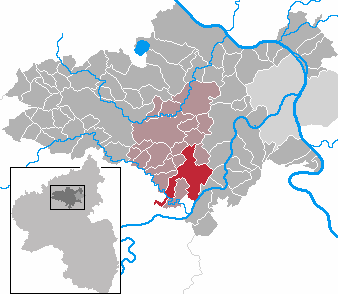
 MünstermaifeldLocation of the town of Münstermaifeld within Mayen-Koblenz district
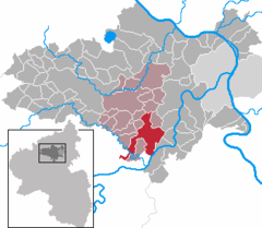
Coordinates 50°14′51″N 7°21′47″E / 50.2475°N 7.36306°ECoordinates: 50°14′51″N 7°21′47″E / 50.2475°N 7.36306°E Administration Country Germany State Rhineland-Palatinate District Mayen-Koblenz Municipal assoc. Maifeld Town subdivisions 6 Mayor Robert Müller (WG Pro-MM) Basic statistics Area 27.78 km2 (10.73 sq mi) Elevation 271 m (889 ft) Population 3,451 (31 December 2010)[1] - Density 124 /km2 (322 /sq mi) Other information Time zone CET/CEST (UTC+1/+2) Licence plate MYK Postal code 56294 Area code 02605 Website www.muenstermaifeld.de Münstermaifeld (German pronunciation: [ˌmʏnstɐˈmaɪfɛlt]) is a town in the district Mayen-Koblenz, in Rhineland-Palatinate, Germany. It is part of the Verbandsgemeinde ("collective municipality") Maifeld. It is situated south-east of Mayen, a few km from the Moselle River and the castle Eltz. The first (b.c.) residents of the region were Celts. The old church is based on a Roman castle-tower. After the Romans, the Franks (Charlemagne) arrived in the 9th century. In the Middle Ages (1277) Münstermaifeld received town privileges and was governed by the bishop of Trier. It is one of the oldest towns in Rhineland-Palatinate and, with its 3,400 citizens, one of the smallest.
References
- ^ "Bevölkerung der Gemeinden am 31.12.2010" (in German). Statistisches Landesamt Rheinland-Pfalz. 31 December 2010. http://www.statistik.rlp.de/fileadmin/dokumente/berichte/A1033_201022_hj_G.pdf.
- This article incorporates information from the German Wikipedia.
-

Town hall of Münstermaifeld
-

"Holy Sepulchre - Entombment of Christ" sculpture in the Maifeldmünster church
External links
Acht · Alken · Andernach · Anschau · Arft · Baar · Bassenheim · Bell · Bendorf · Bermel · Boos · Brey · Brodenbach · Burgen · Dieblich · Ditscheid · Einig · Ettringen · Gappenach · Gering · Gierschnach · Hatzenport · Hausten · Herresbach · Hirten · Kalt · Kaltenengers · Kehrig · Kerben · Kettig · Kirchwald · Kobern-Gondorf · Kollig · Kottenheim · Kretz · Kruft · Langenfeld · Langscheid · Lehmen · Lind · Löf · Lonnig · Luxem · Macken · Mayen · Mendig · Mertloch · Monreal · Mülheim-Kärlich · Münk · Münstermaifeld · Nachtsheim · Naunheim · Nickenich · Niederfell · Niederwerth · Nörtershausen · Oberfell · Ochtendung · Pillig · Plaidt · Polch · Reudelsterz · Rhens · Rieden · Rüber · Saffig · Sankt Johann · Sankt Sebastian · Siebenbach · Spay · Thür · Trimbs · Urbar · Urmitz · Vallendar · Virneburg · Volkesfeld · Waldesch · Weiler · Weißenthurm · Weitersburg · Welling · Welschenbach · Wierschem · Winningen · Wolken
 Categories:
- Towns in Rhineland-Palatinate
- Mayen-Koblenz geography stubs


Wikimedia Foundation. 2010.