- Oklahoma State Highway 6
-
"OK 6" redirects here. OK 6 may also refer to Oklahoma's 6th congressional district.
State Highway 6
Route information Maintained by ODOT Length: 116.4 mi (187.3 km) Existed: August 21, 1954 – present Major junctions South end:  TX-6 at the Texas state line
North end:  SH-152 near Sweetwater
Highway system Oklahoma State Highways
Oklahoma turnpike system←  SH-5
SH-5SH-7  →
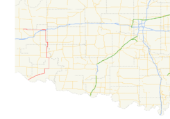
→State Highway 6, abbreviated to SH-6 or OK-6, is a state highway in Oklahoma. It runs in a 116.4 mile[1] (187.3 km) crescent through the southwestern part of the state, running from the Texas state line north of Quanah, Texas, to SH-152 in the unincorporated town of Sweetwater. There are no letter-suffixed spur highways branching from SH-6.
SH-6 was added to the state highway system in 1954. The highway was later extended from its original extent; westward from Elk City in 1957 and southward to Texas in 1975.
Contents
Route description
After crossing the Red River, State Highway 6 leaves Texas, becomes SH-6 and continues headed northeast, passing through the small Jackson County towns of Eldorado and Olustee. Highway 6 meets US-62 five miles (8 km) west of Altus.[2] SH-6 makes a right turn at this point to overlap US-62 into Altus.
In Altus, SH-6 takes a turn to the north to overlap US-283. North of Blair, US-283 heads due north while SH-6 turns toward the northwest. SH-6 crosses US-283 once more before the state highway continues to the north toward Granite, where it meets SH-9.
North of Granite, SH-6 runs along the Beckham–Washita county line until sharing a 4-mile (6.4 km) concurrency with SH-55, moving into Beckham County.[2] After splitting away from SH-55, it meets SH-152 for the first time (it will meet SH-152 at its northern end.)
SH-6 continues north to have an interchange with Interstate 40 in Elk City. It overlaps Business Loop I-40 for four miles (6.4 km) on the north side of the city.[2] At this point the north–south highway curves to the west. It crosses US-283 (again), and then ends at SH-152 in Sweetwater.
History
The original State Highway 6 extended from the Texas state line near Colbert to the Kansas state line north of Vinita.[3] When the United States Numbered Highways system was established in 1926, the vast majority of the highway was overlapped by US-75 and US-73.[4] (Later, this corridor would form the majority of U.S. Route 69 in Oklahoma). As a result, the original SH-6 designation was decommissioned soon after the U.S. highway system's establishment.
The SH-6 designation remained unused until August 21, 1954, when it was assigned to a highway beginning at US-283 east of Mangum, extending north through Granite and Retrop, and ending at US-66 in Elk City.[5][6] The highway was extended west along SH-73 to its current northern terminus on January 21, 1957.[5]
SH-6 was extended to the south on July 7, 1975, bringing it to Altus by way of a concurrency with US-283, where it joined US-62 in another concurrency, headed west. West of Altus, the route split off and headed southwest to the Texas state line. In addition to the U.S. routes, SH-6 was concurrent with SH-44 between that route's current southern terminus and Eldorado, where it ended; thereafter, SH-6 followed SH-34 to the Red River. To remove the redundant designations, both SH-34 and SH-44 were truncated to their current southern terminus on January 5, 1987.[5][7][8]
SH-6 was realigned twice in 2004 to allow SH-6 a straighter route in situations where it was concurrent with another highway. The first such section removed a portion of the US-283 concurrency between Blair and Granite; the second realignment took place on the SH-55 concurrency north of Retrop. Both of these changes were applied to the highway on February 2, 2004.[5] No further changes to the highway's route have taken place since then.
Junction list
County Location Mile[1] Destinations Notes Jackson 0.0 SH 6Southern terminus, Texas state line Eldorado 7.6 SH-5Southern terminus of SH-5 12.5  SH-34
SH-34Southern terminus of SH-34 27.4  US-62
US-62Western end of US-62 concurrency Altus 32.3  US-62 / US-283
Eastern end of US-62 concurrency, southern end of US-283 concurrency Blair 42.4  SH-19
SH-19Western terminus of SH-19 Greer 47.5 US-283Northern end of US-283 concurrency 50.3 US-283Granite 57.3  SH-9
SH-9Kiowa No major junctions Washita–Beckham
county lineRetrop 72.3  SH-55
SH-55Southern end of SH-55 concurrency Beckham 78.3 SH-55Northern end of SH-55 concurrency 83.4 SH-152Elk City 90.2  I-40 / SH-34
Interchange, I-40 exit 38 95.3  BL I-40
Eastern end of BL I-40 concurrency BL I-40Western end of BL I-40 concurrency 105.6 US-283Beckham–Roger Mills
county line116.4 SH-152Northern terminus 1.000 mi = 1.609 km; 1.000 km = 0.621 mi
Concurrency terminus • Closed/Former • Incomplete access • UnopenedReferences
- ^ a b Stuve, Eric. "OK-6". OKHighways. http://www.okhighways.com/ok6.html. Retrieved 2006-04-02.
- ^ a b c Oklahoma Department of Transportation. Official State Map (Map) (2009–10 ed.). http://www.odot.org/hqdiv/p-r-div/maps/state-maps/2009state/pdfs/state-map.pdf. Retrieved 2010-06-18.
- ^ Oklahoma State Highway Department. Oklahoma State Highway System (Map) (1925 ed.). http://www.okladot.state.ok.us/hqdiv/p-r-div/maps/state-maps/pdfs/1925route.pdf. Retrieved 2010-06-20.
- ^ Oklahoma State Highway Department. Oklahoma State Highway System (Map) (1927 ed.). http://www.okladot.state.ok.us/hqdiv/p-r-div/maps/state-maps/pdfs/1927.pdf. Retrieved 2010-06-20.
- ^ a b c d Oklahoma Department of Transportation. "Memorial Dedication and Revision History, SH 6". http://www.okladot.state.ok.us/memorial/legal/sh6.htm. Retrieved 2010-06-20.
- ^ Oklahoma Department of Highways (1955). Highways of Oklahoma (Map). http://www.odot.org/hqdiv/p-r-div/maps/state-maps/pdfs/1955.pdf. Retrieved 2010-06-20.
- ^ Oklahoma Department of Transportation. "Memorial Dedication and Revision History, SH 34". http://www.okladot.state.ok.us/memorial/legal/sh34.htm. Retrieved 2010-06-20.
- ^ Oklahoma Department of Transportation. "Memorial Dedication and Revision History, SH 44". http://www.okladot.state.ok.us/memorial/legal/sh44.htm. Retrieved 2010-06-20.
External links
Categories:- State highways in Oklahoma


Wikimedia Foundation. 2010.