- New York State Route 116
-
NYS Route 116
Route information Maintained by NYSDOT Length: 8.12 mi[2] (13.07 km) Existed: 1930[1] – present Major junctions West end:  US 202 in Somers
 I-684 in North Salem
East end:  Route 116 at North Salem
Location Counties: Westchester Highway system Numbered highways in New York
Interstate • U.S. • N.Y. (former) • Reference • County←  NY 115
NY 117  →
→New York State Route 116 (NY 116) is an east–west state highway in Westchester County, New York, in the United States. It extends for 8.12 miles (13.07 km) from an intersection with U.S. Route 202 (US 202) in the hamlet of Somers to the Connecticut state line, where it becomes that state's Route 116. As it heads east, NY 116 connects to Interstate 684 (I-684) and has an overlap with NY 121. NY 116 originally extended as far west as Peekskill when it was assigned as part of the 1930 renumbering of state highways in New York. It was cut back to its current length in the late 1930s.
Contents
Route description
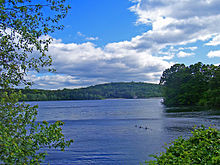 Titicus Reservoir from Route 116
NY 116 begins near the northern terminus of NY 100 at US 202 in the hamlet of Somers as Purdys Road. It heads east into the town of North Salem, where it has junctions with I-684 and NY 22 in the hamlet of Purdys, just after crossing the town line. In North Salem, it is known as Titicus Road, running north of the Titicus Reservoir, serving the hamlets of Salem Center and North Salem. It has an overlap with NY 121 a mile before crossing the Connecticut state line. The route progresses eastward, crossing the state line and continuing as Route 116.
History
NY 116 was originally a much longer route when it was assigned as part of the 1930 renumbering of state highways in New York. At the time, it began in Peekskill and followed modern US 202 east to Somers,[1] from where it continued east over its current alignment to the Connecticut state line.[3] In 1934, US 202 was designated and overlapped with NY 116 from Peekskill to Somers.[4][5] The overlap was eliminated ca. 1938 when NY 116 was truncated to its current western terminus in Somers.[6][7]
Major intersections
The entire route is in Westchester County.
Location Mile[2] Destinations Notes Somers 0.00 US 202North Salem 1.32 I-684 southExit 7 (I-684) 1.41  NY 22
NY 225.36 June Road (CR 310) Formerly part of NY 124 5.90  NY 121 south (Grant Road)
Western terminus of NY 116 / NY 121 overlap 7.03 NY 121 north (Peach Lake Road)Eastern terminus of NY 116 / NY 121 overlap 8.12 Route 116Continuation into Connecticut 1.000 mi = 1.609 km; 1.000 km = 0.621 mi References
- ^ a b Standard Oil Company of New York (1930). Road Map of New York (Map). Cartography by General Drafting.
- ^ a b "2008 Traffic Volume Report for New York State" (PDF). New York State Department of Transportation. June 16, 2009. p. 164. https://www.nysdot.gov/divisions/engineering/technical-services/hds-respository/NYSDOT%20TVR%202008%20by%20Route.pdf. Retrieved January 31, 2010.
- ^ Texas Oil Company (1932). Texaco Road Map – New York (Map). Cartography by Rand McNally and Company.
- ^ Weingroff, Richard (January 9, 2009). "U.S. 202 – Maine to Delaware". Highway History. Federal Highway Administration. http://www.fhwa.dot.gov/infrastructure/us202.cfm. Retrieved March 31, 2010.
- ^ Sun Oil Company (1935). Road Map & Historical Guide – New York (Map). Cartography by Rand McNally and Company.
- ^ Shell Oil Company (1937). Shell Road Map – New York (Map). Cartography by H.M. Gousha Company.
- ^ Thibodeau, William A. (1938). The ALA Green Book (1938–39 ed.). Automobile Legal Association.
External links
Categories:- State highways in New York
- Transportation in Westchester County, New York


Wikimedia Foundation. 2010.