- Knox Atoll
-
Knox Atoll 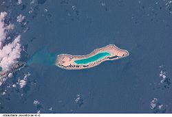
NASA picture of Knox Atoll
 Knox Atoll (Marshall islands)
Geography Location North Pacific Coordinates 05°54′00″N 172°09′00″E / 5.9°N 172.15°E Archipelago Ratak Total islands 18 Area 0.98 km2 (0.378 sq mi) Highest elevation 3 m (10 ft) Country Demographics Population 0 Knox Atoll (Marshallese: Ņadikdik, /nˠaɦˠrʲɨkrʲɨk/ or [n̴ɑʕr̟i͡ɯɡɯ͡ir̟i͡ɯk][1]) is an unihabited coral atoll of 18 islands in the Pacific Ocean, and is the southernmost atoll of the Ratak Chain of the Marshall Islands. The total land area is only 0.98 square kilometres (0.38 sq mi), but it encloses a largely sand-filled lagoon with an area of 3.42 square kilometres (1.32 sq mi). The atoll measures 11 kilometres (6.8 mi) in length and is 2 kilometres (1.2 mi) wide. The largest islets, located on the western and northern sides, include Aelingeo, Nadikdik and Nariktal. The atoll is connected by the Klee Passage to the southern point of Mili Atoll to which it was once connected.
History
Knox Atoll was claimed by the Empire of Germany along with the rest of the Marshall Islands in 1884. After World War I, the island came under the South Pacific Mandate of the Empire of Japan. Following the end of World War II, it came under the control of the United States as part of the Trust Territory of the Pacific Islands until the independence of the Marshall Islands in 1986.
Notes
Reference
Marshall Islands - Bold indicates populated islands
- Italics indicate single island
Ratak Chain (Sunrise, Eastern) 
Ralik Chain (Sunset, Western) Categories:- Atolls of the Marshall Islands
- Ratak Chain
- Uninhabited islands of the Marshall Islands
- Marshall Islands geography stubs


Wikimedia Foundation. 2010.