- Paktia Province
Geobox|Province
country = Afghanistan
country_
name = Paktia
native_name = پکتیا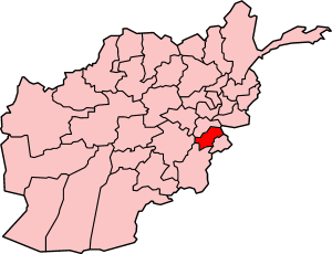
map_caption = Map of Afghanistan with Paktia highlighted
capital = Gardez
capital_lat_d = 33.6
capital_long_d = 69.5
population_as_of = 2002
population = 415,000
population_note = [ [http://afghanistan.usaid.gov/en/Province.26.aspx Afghanistan's Provincesndash Paktia at USAID] ]
area = 6432
population_density =
timezone = UTC+4:30
free_type = Main language
free = Pashto Paktia ( _ps. پکتيا) is one of the thirty-fourprovinces of Afghanistan , in the east of the country. Its capital is Gardez.History
Najibullah Ahmadzai , the former president of Afghanistan, was from Paktia province, in particular the Melan Valley area. Paktia used to be a unified province withKhost andPaktika , these three provinces are now referred to as Loya Paktia which means The Greater Paktia. Paktia came to prominence during the 1980s where a significant portion of the leftist communists came from Paktia, some of the more notable of them include:Najibullah Ahmadzai ;Mohammad Aslam Watanjar ;Shahnawaz Tanai ; and Gulabzoy.Governance
The uncertain security situation and remoteness of the province has led to many provincial Governors being appointed in the short time since the fall of the
Taliban . After the assassination ofHakim Taniwal in September 2006,Rahmatullah Rahmat was appointed as provincial Governor.Paktia has a strong
Pashtun tribal identity, and Pashtun nationalists in the province have expressed a desire to reunite the province withKhost Province andPaktika province, forming an ethnicPashtunistan .Despite the many problems facing the province, it is one of the more stable in the southeast of the country and there has been a concerted effort to improve the civic infrastructure, giving Paktia a reasonable rate of reconstruction [http://pajhwok.com/viewstory.asp?id=14501] . The first American
Provincial Reconstruction Team base was established in Gardez to supply security and reconstruction, and has funded several successful projects.ecurity Situation
In September 2006, Governor
Hakim Taniwal was killed by aTaliban suicide bomber as he left his office in Gardez [http://news.bbc.co.uk/2/hi/south_asia/5331986.stm] . At the time, Taniwal was the highest-ranking post-Taliban official to be killed by insurgent forces in the country.Paktia is one of the most politically complicated provinces in the country. Militia commanders are a strong presence in the province, and their shifting allegiances and violent tendencies make governance of the region problematic. The province also has the difficult mountainous and cavernous terrain typical of the
Hindu Kush range, providing armed groups ample cover from which to conduct guerilla operations.Immediately after the fall of the
Taliban , Paktia was one of the most chaotic regions in the country, as a small civil war broke out between rival militia commanders for control of the province, and Taliban andAl-Qaeda fighters gave occupying U.S. troops some of their heaviest losses in the cave complexes south of Gardez [http://www.globalsecurity.org/military/world/afghanistan/zadran.htm] .The security situation in Paktia has improved significantly in recent years, though isolated fighting by Taliban militants and persistent tribal conflicts in the eastern part of the province continue to challenge the government. The provincial capital, Gardez, is among the most secure in the southeastern part of the country, owing in part to a large presence by coalition and Afghan security forces.
Geography
Paktia borders the Pakistani-ruled tribal areas of
North Waziristan andKurram . Like most of the traditionalPashtun eastern areas of Afghanistan, theDurand Line that marks the border with Pakistan is "drawn on water", and residents move freely between the two countries.Major tribes in the province include the Totakhil,
Zazi ,Mangal , Zadran,Wazir ,Ahmadzai , Gurbaz,Niazi ,Tanoli , andKurram .Paktia is made up of 12 district (District Centers are given in parentheses):
*Ahmadzai District (Ahmadaba)
*Chamkani District
*Dand-A-Patan (Ghondai)
*Gardez District (Gardez, Afghanistan)
*Jani Khel District (Jani Khel)
*Lazha Mangal District (Lazha)
*Sayed Karam District (Seyyed Karam)
*Shwak District (Shwak)
*Garda Serai District
*Zadran District (Waza)
*Zazi (Ali Khel)
*Zurmat District (Zarmal)Important Villages of Center Gardez:
*Baladeh
*Kuceen
*Malak Khel
*Karmashi
*Koji khel
*Sar e Sang
*Shikhan
*Khtaba
*Shakar Khel
*Tera
*Dawlat ZaiImprotant Villages of Chamkani District:
*Star Kalai
*Babo Khail
*Alwarai
*Mada Khail
*Gramai
*Mangiar
*Bagyar
*Tana
*Nargasai
*HesarakImportant geographical features
*
Shah-i-Kot Valley Important valley Srengor valley chamkani district paktia province Mangyar Valley chamkani district paktia province Hassan Khail valley Ahmad Khail District Paktia Province this information by HimmatReferences
Women Setuation and the way of living in Afghanistan especilly in Paktia province for more details click: http://www.realafghan.7p.com
External links

Wikimedia Foundation. 2010.