- Otago Harbour
-
 Location of Otago Harbour in Southern Island.
Otago Harbour is the natural harbour of Dunedin, New Zealand, consisting of a long, much-indented stretch of generally navigable water separating the Otago Peninsula from the mainland. They join at its southwest end, 21 km (13 mi) from the harbour mouth. It is home to the deep water port of Port Chalmers.[1]
Contents
Geography
 NASA satellite photo of Otago Harbour
The harbour was formed from the drowned remnants of a giant shield volcano, centred close to what is now the town of Port Chalmers. The remains of this violent origin can be seen in the basalt of the surrounding hills. The last eruptive phase ended some ten million years ago, leaving the prominent peak of Mount Cargill.[2][3]
Substantial container port facilities exist at Port Chalmers, 9 km (6 mi) along the western shore from the harbour mouth. A channel along the western side of the harbour is regularly dredged, allowing vessels with a draught of 12.5 m to Port Chalmers, and 8 m all the way to the heart of Dunedin.[4] New Zealand's frozen meat export trade was inaugurated at Port Chalmers in 1882. The dredging of this channel, the Victoria Channel, was a major undertaking for the settlement of Dunedin in the 19th century. The eastern side of the harbour is shallow, with large sandbanks exposed at low tide.
 Map showing land reclamation since 1848 at the head of the harbour
Two islands form a line between Port Chalmers and Portobello in the lower harbour - Goat Island and Quarantine Island/Kamau Taurua. A smaller island known as Pudding Island (Titeramoa) [5] lies close to the Peninsula shore and can be reached dry foot at low tide.
Portobello is home to one of New Zealand's leading marine research establishments, the Portobello Marine Laboratory, a department of the University of Otago. This lies at the harbour's edge on the tip of a small arm of the Otago Peninsula, the Portobello Peninsula.
Near the mouth of the harbour lies the township of Aramoana (Maori for "pathway to the sea"), infamous for a massacre of 13 people by a gunman, David Gray, in November 1990.
This is also the site twice projected for New Zealand's second aluminium smelter. The proposals, in the mid 1970s and early 1980s, were abandoned after major public protest. The area is the home of many species of wading birds. Other species which visit the harbour include two species of penguins, sea lions, four species of seals, and several species of cetaceans(dolphins and whales) and Taiaroa Head, at the tip of the Otago Peninsula, is home to a colony of Northern Royal Albatrosses, the only such close to a city in the world.
The harbour is tidal, shallow and seldom rough and for that reason is popular for water sports such as yachting and windsurfing.
A significant area at the head of the harbour has been reclaimed since the founding of Dunedin, primarily for industrial use.[6] Smaller portions have also been reclaimed at a number of places around the harbour, including Port Chalmers, Macandrew Bay, and Broad Bay.
History
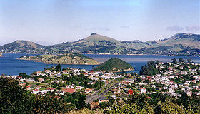 Looking across Port Chalmers and the Otago Harbour to the Otago Peninsula
The existence of the harbour was guessed by Captain Cook when he was off what is now the Dunedin Pacific coast in 1770.[7] It is not known when the first Europeans entered but it was some time 'long before' 1810, according to the Creed manuscript discovered in 2003.[8] George Bass made the Dunedin end of the harbour the north east limit of his proposed fishing monopoly in 1803.[9] The American ship Favorite with its supercargo Daniel Whitney may have called in the summer of 1805 to 1806. Daniel Cooper, master of the London sealer Unity probably did call in the summer of 1808 to 1809 when his Chief Officer, Charles Hooper, probably gave his name to Hooper's Inlet on the Otago Peninsula.[10] William Tucker (1784–1817) was with a gang employed by Robert Campbell a Sydney merchant, dropped on islands off the Dunedin coast in November 1809 and with another man, Daniel Wilson, was at Otago Harbour on May the 3rd 1810 when Robert Mason, master of the Brothers anchored in the harbour and picked him up. This is the first, explicit and identifiable reference to a European ship in the Otago Harbour. The court record containing it, made in 1810, refers to the harbour as 'Port Daniel', a name which stayed in use for some years.[11]
Another English sealer, the Sydney Cove, Captain Charles McLaren, was anchored in the harbour late in 1810 when Te Wahia's theft of a knife, a red shirt and some other articles sparked what has been called "The Sealers' War" - also - the 'War of the Shirt'.[12]
 The entrance to Otago Harbour from Taiaroa Head
A notable affray in that conflict occurred after James Kelly of Hobart anchored the Sophia in the harbour in December 1817 with William Tucker on board. After a visit to nearby Whareakeake (Murdering Beach) where Tucker had been living since 1815 and where he and two other men were now killed Kelly took revenge on Māori on his ship in the harbour, including a chief Korako. He then burnt a harbourside village,'the beautiful City of Otago', probably on Te Rauone Beach and certainly not at Whareakeake as has often been suggested.[13]
A peace was concluded in 1823 and on 17 July of that year John Rodolphus Kent of the Naval cutter Mermaid from New South Wales, while in the Harbour, took 'the liberty of naming it (as it has not hitherto been named) "Port Oxley", in honour of the Surveyor General of the Colony' in fact John Oxley (1783/85?-1828).[14] As noted, it had already been named. In 1826 Thomas Shepherd, one of a party of intending colonists, explored the site of Dunedin and left the oldest surviving pictures of the harbour and nearby coast, now in the Mitchell Library Sydney (Mitchell Library (Australia).[15]
From its origins as a secret sealers' haven Otago Harbour developed into a busy international whaling port after the Weller brothers established their whaling station at Te Umu Kuri, Wellers Rock, at what is now called Otakou in November 1831.[16] The busiest whaling port south of the Bay of Islands, it was also the hub of the largest European population in New Zealand after the Bay of Islands/Hokianga district by the end of 1839. By that time whaling had collapsed and Dumont D'Urville and his officers, visiting in 1840, observed the port had become the centre of a riotous trade in liquor and prostitution.[17] This continued until the Scottish settlers arrived in 1848 and made Port Chalmers and Dunedin the new population centres on the harbour.
Harbourside settlements
Settlements by the harbour include (in order from the mouth of the harbour):
- On the western shore:
- Aramoana
- Careys Bay
- Port Chalmers
- Sawyers Bay (with a tannery)
- Roseneath
- Saint Leonards
- Ravensbourne (with a fertiliser works)
- On the eastern shore:
- Harington Point
- Weller's Rock (With access to the albatross colony, seal colony, and Fort Taiaroa)
- Otakou
- Harwood
- Portobello
- Broad Bay
- Macandrew Bay
- Challis
- Andersons Bay
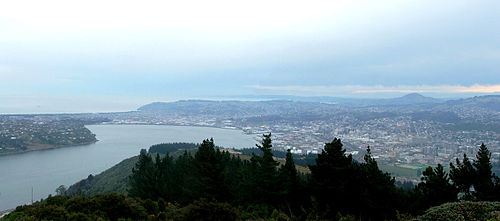 The Otago Harbour basin and central Dunedin, as seen from Signal Hill.
References
- ^ Harvey, Sarah (9 August 2007). "Otago Port to get into deep water". New Zealand Herald. http://www.nzherald.co.nz/topic/story.cfm?c_id=284&objectid=10456610. Retrieved 2008-05-21.
- ^ Coombs, D. S., Dunedin Volcano, Misc. Publ. 37B, pp. 2–28, Geol. Soc. of N. Z., Dunedin, 1987.
- ^ Coombs, D. S., R. A. Cas, Y. Kawachi, C. A. Landis, W. F. Mc-Donough, and A. Reay, Cenozoic volcanism in north, east and central Otago, Bull. R. Soc. N. Z., 23, 278–312, 1986.
- ^ "Otago Harbour Information". Port Otago. http://www.portotago.co.nz/8.html. Retrieved 2008-05-21.
- ^ http://www.linz.govt.nz/placenames/consultation-decisions/decisions-archive/20090529/crown-protected/otago/index.aspx
- ^ "Manufacturing in Dunedin". Otago Chamber of Commerce. http://www.otagochamber.co.nz/manufacturing.asp. Retrieved 2008-05-21.[dead link]
- ^ James Cook in J.C. Beaglehole (ed), The Journals of Captain James Cook, the Voyage of the Endeavour, 1768-1771, London, UK: Cambridge University Press for the Hakluyt Society, 1955, (1968), pp.257-259.
- ^ Quote from the Creed MS its text reproduced in Peter Entwisle,Taka: a Vignette Life of William Tucker 1784-1817, Dunedin, NZ: Port Daniel Press, 2005, pp.128-131, the quote at p.128.
- ^ Robert McNab (ed) Historical Records of New Zealand, 2 vols Wellington, NZ:Government Printer, 1908 & 1914.
- ^ Peter Entwisle, Behold the Moon: the European Occupation of the Dunedin District 1770-1848, Dunedin, NZ: Port Daniel Press, 1998 p.21.
- ^ Peter Entwisle, Taka: A Vignette Life of William Tucker 1784-1817, Dunedin, NZ: Port Daniel Press, 2005, pp.53-66 & pp.110-115 for the relevant court records.
- ^ Peter Entwisle, Taka: a Vignette Life of William Tucker 1784-1817, Dunedin, NZ: Port Daniel Press, 2005, pp.70-71.
- ^ Peter Entwisle, Taka: a Vignette Life of William Tucker 1784-1817, Dunedin, NZ: Port Daniel Press, 2005, pp.94-97, quoting James Kelly in the Hobart Town Courier 12 April 1858.
- ^ John Rodolphus Kent, Journal kept from May to August 1823 on the cutter Mermaid of a voyage to New Zealand waters, manuscript ZA4037, Mitchell Library, State Library of New South Wales, Sydney.
- ^ Thomas Shepherd, [Journal], MS A1966, Mitchell Library, State Library of New South Wales, Sydney.
- ^ Peter Entwisle, Behold the Moon: The European Occupation of the Dunedin District 1770-1848, Dunedin, NZ: Port Daniel Press, 1998,p.83.
- ^ Olive Wright, ed & translator, The Voyage of the Astrolabe 1840, Wellington, NZ: A.H. & A.W. Reed, 1955.
External links
Categories:- Otago Region
- Dunedin
- Otago Peninsula
- Ports and harbours of New Zealand
- Volcanoes of New Zealand
- Shield volcanoes
- Volcanic calderas of New Zealand
- Submarine calderas
- Miocene volcanoes
- Extinct volcanoes
- On the western shore:


Wikimedia Foundation. 2010.