Indiana State Road 29

Indiana State Road 29

State Road 29 marker

State Road 29
Route information
Maintained by INDOT
Length: 31.6 mi[1] (50.9 km)
Major junctions
South end: US 421 / SR 28 at Boyleston
North end: US 35 at Logansport
Location
Counties: Clinton, Carroll, Cass
Highway system

Indiana roads
Interstates • U.S. Routes • State Roads • Former

SR 28 SR 32

State Road 29 is a north–south road in north-central Indiana.

Contents

Route description

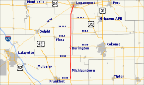
The southern terminus of State Road 29 is at U.S. Route 421 and State Road 28 just south of the small town of Boyleston. Going north, it passes through Michigantown in Clinton County, then along the eastern border of Carroll County where it passes through Burlington. Its northern terminus is at U.S. Route 24 and U.S. Route 35 on the south side of Logansport.

History

At one time, State Road 29 was much longer, going from Madison in the south to Michigan City in the north; when US 421 was commissioned, it took over much of the route. The original road was laid out in the 1830s and construction on the first road was completed in 1841. It was known as "Michigan Road."

Major intersections

County Location Mile[2] Destinations Notes
Clinton
Michigan Township 0.00 US 421 / SR 28 – Frankfort, Indianapolis, Tipton Southern terminus of SR 29
Warren Township 9.35 SR 26 – Lafayette, Kokomo  
Carroll
Burlington 13.82 SR 22 east – Kokomo Western terminus of SR 22
Carrollton Township 18.45 SR 18 west – Delphi Southern end of SR 18 concurrency
19.96 SR 18 east – Marion Northern end of SR 18 concurrency
Washington Township 22.78 SR 218 west Southern end of SR 218 concurrency
26.48 SR 218 east Northern end of SR 218 concurremcy
Cass
Logansport 31.57 US 35 / US 24 – LaPorte, Peru Northern terminus of SR 29
1.000 mi = 1.609 km; 1.000 km = 0.621 mi

References

  1. ^ Indiana Highway Ends - SR 29
  2. ^ "INDOT Roadway Referencing System" (PDF). staff. http://www.in.gov/indot/files/StateWide_2004.pdf. 

Wikimedia Foundation. 2010.

Игры ⚽ Нужно сделать НИР?

Look at other dictionaries:

  • Indiana State Road 47 — Infobox road state=IN type=IN route=47 alternate name= length mi=64.2 length round=1 length ref= [http://illi indi.com/EndsPage.php?id=1047 section=1 Indiana Highway Ends SR 47] ] established= direction a=South starting terminus= junction=… …   Wikipedia

  • Indiana State Road 4 — Infobox road marker state=IN highway name= name notes= type=IN route=4 alternate name= section= length mi= length round= length ref= length notes= established= decommissioned= direction a= starting terminus= beltway city= junction= direction b=… …   Wikipedia

  • Indiana State Road 43 — Infobox road state=IN type=IN route=43 alternate name= length mi= length round= length ref= established= direction a= starting terminus=IN 54 near Cincinnati direction b= ending terminus=US 24/US 421 in Reynolds counties=Greene, Owen, Tippecanoe …   Wikipedia

  • Indiana State Road 11 — Infobox road marker state=IN highway name= name notes= type=IN route=11 alternate name= maint=Indiana Department of Transportation section= length mi= length round= length ref= length notes= established= decommissioned= direction a= starting… …   Wikipedia

  • Indiana State Road 53 — Infobox road state=IN type=IN route=53 alternate name=Broadway length mi=14.1 length round=1 length ref= [http://illi indi.com/EndsPage.php?id=1053 section=1 Indiana Highway Ends SR 53] ] established= direction a=South starting terminus= junction …   Wikipedia

  • Indiana State Road 14 — Infobox road state=IN type=IN route=14 alternate name= length mi=123 length round= length ref= [http://illi indi.com/EndsPage.php?id=1014 section=1 Indiana Highway Ends SR 14] ] established= direction a=West starting terminus= junction= direction …   Wikipedia

  • Indiana State Road 8 — Infobox road marker state=IN highway name= name notes= type=IN route=8 alternate name= section= length mi= length round= length ref= length notes= established= decommissioned= direction a= starting terminus= beltway city= junction= direction b=… …   Wikipedia

  • Indiana State Road 38 — Infobox road state=IN type=IN route=38 alternate name=Bataan Memorial Highway maint=INDOT length mi=116.4 length round=2 length ref= [http://illi indi.com/EndsPage.php?id=1038 section=1 Indiana Highway Ends SR 38] ] established= direction a=West… …   Wikipedia

  • Indiana State Road 329 — State Road 329 was a state road in Cass County, Indiana. It was a connector from Indiana State Road 29 s northern terminus at the U.S. Highway 24/U.S. Highway 35 bypass south of the city of Logansport to Indiana State Road 17 s southern terminus… …   Wikipedia

  • Indiana State Road 123 — State Road 123 was a north south state road in Saint Joseph County, Indiana. It ran along the western edge of the city of South Bend. Former routingFollowing Mayflower Road for its entire route, it began from its parent Indiana State Road 23,… …   Wikipedia

  • Indiana State Road 223 — State Road 223 was a northeast southwest state highway in Saint Joseph County, Indiana. It was about 7 miles long.SR 223 began from the south at one of its parent routes, Indiana State Road 23. It followed the Crumstown Highway north through… …   Wikipedia

Share the article and excerpts

Direct link
Do a right-click on the link above
and select “Copy Link”