- New York State Route 295
-
For the Interstate Highway in New York City, see Interstate 295 (New York).
NYS Route 295
Route information Maintained by NYSDOT (NY 295) and MassDOT (MA 295) Length: 12.88 mi[4] (20.73 km)
MA 295: 1.668 mi (2.684 km)[1]Existed: ca. 1931[2][3] – present Major junctions West end:  NY 66 in Chatham
East end:  Route 41 in Richmond, MA (as MA 295)
Location Counties: Columbia, Berkshire (MA) Highway system Numbered highways in New York
Interstate • U.S. • N.Y. (former) • Reference • County←  NY 294
NY 296  →
→←  I-295
I-295
I-391  →
→New York State Route 295 (NY 295) is a 12.88-mile (20.73 km) state highway in Columbia County, New York, in the United States. It begins at an intersection with NY 66 in the village of Chatham and heads generally easterly to the Massachusetts border in the town of Canaan, where the road becomes that state's Route 295 and continues for another 1.668 miles (2.684 km) to a junction with Route 41 in Richmond, Massachusetts. Route 295 is the highest numbered Massachusetts state highway.
Contents
Route description
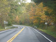 Eastbound on NY 295 in Chatham between the Taconic Parkway and I-90
At its western terminus, NY 295 begins at NY 66 in the village of Chatham, initially known as Railroad Avenue. As the road changes names to Spring Street, the Stony Kill approaches from the west and roughly parallels NY 295 for much of its duration. Within the hamlet, NY 295 intersects several local roads and a pair of train tracks. The highway proceeds towards the northwest as it passes to the east of a pond, and subsequently intersects the Taconic State Parkway. Upon crossing the state parkway, NY 295 takes a more easterly direction; however, it turns towards the northwest when it reaches New Concord Road. The road intersects the Berkshire Connector of the New York State Thruway, or Interstate 90 (I-90), and enters the hamlet of East Chatham.[5]
In East Chatham, NY 295 becomes concurrent with County Route 9. When the two highways split, NY 295 heads towards the east. Several local highways intersect from the north, while the highway remains routed along the Stony Kill. The road bends towards the southeast into Canaan, where the Stony Kill turns sharply towards the north and NY 295 crosses the Queechy Lake Brook. Crossing between two mountains, the highway passes to the southwest of Queechy Lake, and intersects with NY 22. After a final, brief turn to the east, NY 295 crosses the New York – Massachusetts border; it continues into Massachusetts as Route 295, a connector road between NY 295 and Route 41.[5]
History
 Turnoff for Route 295 on Route 41 in Richmond, Massachusetts
The first state route to serve the hamlet of East Chatham was NY 204, an east–west route assigned as part of the 1930 renumbering of state highways in New York. NY 204 began at NY 66 in Malden Bridge and followed Albany Turnpike Road to East Chatham, from where it continued southeast to the Massachusetts state line by way of a series of roads in the modern Interstate 90 corridor.[2] The route was extended northwest to U.S. Route 20 in Nassau by the following year[6] and realigned east of East Chatham to follow what is now NY 295 to a new state line crossing at Canaan ca. 1935. The short 1.5-mile (2.4 km) continuation of NY 204 to Route 41 in Richmond, Massachusetts, was designated as Route 204 around this time.[7][8]
NY 295, meanwhile, was assigned ca. 1931 to an alignment extending from Austerlitz to East Chatham. At the time, the route began at an intersection with NY 203 southeast of Chatham and headed to the northeast, bypassing Chatham to the east on Bushnell and Birge Hill Roads. It joined its modern alignment southwest of East Chatham and followed it into the hamlet, where the route ended at a junction with NY 204.[2][3] The portion of NY 295 south of East Chatham was realigned to follow its current alignment ca. 1938. Around the same time, NY 295 was extended eastward to the state line, replacing part of NY 204. Massachusetts subsequently renumbered Route 204 to Route 295 in order to preserve the number continuity.[9][10]
NY 204 was truncated to East Chatham following the extension of NY 295. It remained in this truncated form until it was eliminated entirely in the early 1940s.[11][12] A small segment of NY 204's original routing between the then-proposed routing of NY 22 and the state line at West Stockbridge, Massachusetts, became NY 432 after NY 204 was realigned ca. 1935. As originally planned, NY 22 would have followed a more westerly alignment through Austerlitz and Canaan;[7][8] however, the road was ultimately built on a path that supplanted most of NY 432. As such, the NY 432 designation was removed after the new stretch of NY 22 opened in 1940.[11] A small section of NY 432's former right-of-way between NY 22 and the Massachusetts state line is still state-maintained as NY 980D, an unsigned reference route.[13]
Major intersections
County Location Mile[1][4] Destinations Notes Columbia Village of Chatham 0.00 NY 66Town of Chatham 2.70  Taconic Parkway
Interchange Canaan 11.93  NY 22
NY 2212.88
0.000New York – Massachusetts state line; roadway becomes NY 295 westbound and MA 295 eastbound Berkshire Richmond 1.668 Route 411.000 mi = 1.609 km; 1.000 km = 0.621 mi References
- ^ a b Executive Office of Transportation, Office of Transportation Planning - 2005 Road Inventory
- ^ a b c Standard Oil Company of New York (1930). Road Map of New York (Map). Cartography by General Drafting.
- ^ a b Standard Oil Company (1931). New York (Map). Cartography by General Drafting.
- ^ a b "2008 Traffic Volume Report for New York State" (PDF). New York State Department of Transportation. June 16, 2009. p. 208. https://www.nysdot.gov/divisions/engineering/technical-services/hds-respository/NYSDOT%20TVR%202008%20by%20Route.pdf. Retrieved February 1, 2010.
- ^ a b Google, Inc. Google Maps – overview map of New York State Route 295 (Map). Cartography by Google, Inc. http://maps.google.com/maps?f=d&source=s_d&saddr=NY-295%2FRailroad+Ave&daddr=42.389901,-73.396708&geocode=FQJjhgIdSv-c-w%3B&hl=en&mra=mi&mrsp=1,0&sz=17&sll=42.390375,-73.396558&sspn=0.005586,0.013926&ie=UTF8&ll=42.391643,-73.495617&spn=0.089381,0.222816&t=h&z=13. Retrieved June 8, 2009.
- ^ Kendall Refining Company (1931). New York (Map). Cartography by H.M. Gousha Company.
- ^ a b Texas Oil Company (1934). Texaco Road Map – New York (Map). Cartography by Rand McNally and Company.
- ^ a b Sun Oil Company (1935). Road Map & Historical Guide – New York (Map). Cartography by Rand McNally and Company.
- ^ Shell Oil Company (1937). Shell Road Map – New York (Map). Cartography by H.M. Gousha Company.
- ^ Esso (1938). New York Road Map for 1938 (Map). Cartography by General Drafting.
- ^ a b Shell Oil Company (1940). Map of New York (Map). Cartography by H.M. Gousha Company. The map gives August 1940 as the scheduled completion date for the under-construction section of NY 22.
- ^ Esso (1942). New York with Pictorial Guide (Map). Cartography by General Drafting.
- ^ New York State Department of Transportation (January 2009) (PDF). Official Description of Highway Touring Routes, Bicycling Touring Routes, Scenic Byways, & Commemorative/Memorial Designations in New York State. https://www.nysdot.gov/divisions/operating/oom/transportation-systems/repository/2009%20tour-bk.pdf. Retrieved January 22, 2011.
External links

Wikimedia Commons has media related to: Categories:- State highways in New York
- Transportation in Columbia County, New York


Wikimedia Foundation. 2010.