- Englishcombe
-
Coordinates: 51°21′47″N 2°24′26″W / 51.3631°N 2.4071°W
Englishcombe 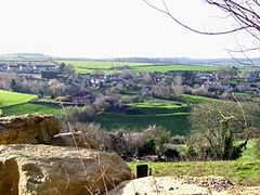
View of Englishcombe
 Englishcombe
Englishcombe shown within SomersetPopulation 332 [1] OS grid reference ST717627 Unitary authority Bath and North East Somerset Ceremonial county Somerset Region South West Country England Sovereign state United Kingdom Post town Bath Postcode district BA2 Police Avon and Somerset Fire Avon Ambulance Great Western EU Parliament South West England UK Parliament North East Somerset List of places: UK • England • Somerset Englishcombe is a village and civil parish in Bath and North East Somerset just outside Bath, England. The parish, which also includes the hamlets of Inglesbatch, Nailwell and Wilmington, has a population of 332.[1]
Contents
History
A neolithic axe has been found in the parish, and iron age pottery was discovered during construction of Culverhay School. There is also some evidence of two possible barrows.[2]
The south eastern boundary of the parish follows the route of the Fosse Way a Roman road that linked Exeter (Isca Dumnoniorum) in South West England to Lincoln (Lindum Colonia) in the East Midlands, via Ilchester (Lindinis), Bath (Aquae Sulis), Cirencester (Corinium) and Leicester (Ratae Corieltauvorum).
The village lies on the route of the Wansdyke (from Woden's Dyke) an early medieval or possibly defining an Roman boundary with a series of defensive linear earthworks, consisting of a ditch and a running embankment from the ditch spoil, with the ditching facing north. Its construction is attributed to the pagan Saxons, probably in the late sixth century.[3] The parish of Englishcombe was part of the Wellow Hundred.[4]
The Domesday Book of 1086 records that Englishcombe was held by Nigel de Gournay, who would have won his lands in Englishcombe, Twerton, Swainswick and Barrow Gurney by fighting for William I of England. His original home must have been Gournay, which was half-way between Dieppe and Paris.
Thomas de Gournay was involved with the murder of Edward II at Berkeley Castle in 1327.[5] The earthwork remains of the Gournay family castle, just north of the village of Englishcombe known as Culverhay Castle was built in the 12th century and is now a Scheduled Ancient Monument.[6][7]
 Tithe Barn
The tithe barn attached to Rectory Farmhouse was built by Bath Abbey in the early 14th century.[8] It was restored in the 1990s[9] and has been designated as a Grade II* listed building.[10] Rectory Farmhouse itself was built onto the barn in the early to mid 17th century.[11]
The Manor of Inglescombe, as it was previously called, was acquired by the Duchy of Cornwall in 1421. Along with the Duchy's more recent acquisition of the neighbouring village of Newton St Loe in 1941 they form the Duchy's largest estate outside Dartmoor.[12]
The mining of Fuller's earth started in the parish in the 19th century but expanded around the time of World War I with pits in Middle Wood and Vernham wood. It continued until the 1960s when small underground springs made the extraction to expensive to continue.[13]
Governance
The parish council has responsibility for local issues, including setting an annual precept (local rate) to cover the council’s operating costs and producing annual accounts for public scrutiny. The parish council evaluates local planning applications and works with the local police, district council officers, and neighbourhood watch groups on matters of crime, security, and traffic. The parish council's role also includes initiating projects for the maintenance and repair of parish facilities, such as the village hall or community centre, playing fields and playgrounds, as well as consulting with the district council on the maintenance, repair, and improvement of highways, drainage, footpaths, public transport, and street cleaning. Conservation matters (including trees and listed buildings) and environmental issues are also of interest to the council.
The parish falls within the unitary authority of Bath and North East Somerset which was created in 1996, as established by the Local Government Act 1992. Between April 1, 1974 and April 1, 1996, it was the Wansdyke district and the City of Bath of the county of Avon.[14] Before 1974 that the parish was part of the Bathavon Rural District.[15]
The parish is represented in the House of Commons of the Parliament of the United Kingdom as part of North East Somerset, which elects one Member of Parliament (MP) by the first past the post system of election. It is also part of the South West England constituency of the European Parliament which elects seven MEPs using the d'Hondt method of party-list proportional representation.
St Peter's Church
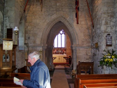
The Church of St Peter, was probably built by Robert de Gournay in the 12th century.[5] The church features Norman arches (see middle photo), and leper holes in the porch (right-hand photo), which would have enabled lepers to hear the sermon without coming into contact with the rest of the congregation.[16] It has been designated as a Grade I listed building.[17]
-
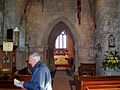
Inside the church
-
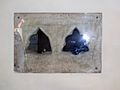
Leper holes
References
- ^ a b "Population Statistics for Bath & North East Somerset". Statistics and Census Information. Bath and North East Somerset. http://www.bathnes.gov.uk/councilanddemocracy/statisticsandcensusinformation/Pages/default.aspx. Retrieved 2010-10-07.
- ^ Historic Survey of the Manor of Englishcombe, Avon County Planning Department, 1983, pp. 5, ISBN 0860631907, http://www.englishcombe.net/pdf/landscape%20survey.pdf
- ^ Cyril and Aileen Fox, "Wandyke reconsidered", Archaeological Journal (1958)
- ^ "Somerset Hundreds". GENUKI. http://www.genuki.org.uk/big/eng/SOM/Miscellaneous/. Retrieved 22 October 2011.
- ^ a b Manco, J. (1995) The Parish of Englishcombe: A History, pp. 2, 4.
- ^ "Culverhay Castle, Englishcombe". The Gatehouse. http://homepage.mac.com/philipdavis/English%20sites/13.html. Retrieved 7 March 2011.
- ^ "Culverhay Castle". Fortified England. http://www.fortifiedengland.com/Home/Categories/ViewItem/tabid/61/Default.aspx?IID=1405. Retrieved 7 March 2011.
- ^ "Englishcombe Tithe Barn, Rectory Farmhouse". English Heritage. http://www.english-heritage.org.uk/daysout/grant-aided-properties/englishcombe-tithe-barn-rectory-farmhouse-ba2-9du/. Retrieved 7 March 2011.
- ^ "Tithe Barn". Englishcombe.net. http://www.englishcombe.net/tithebarn.htm. Retrieved 7 March 2011.
- ^ "Tithe Barn attached to south end of Rectory Farm". Images of England. English Heritage. http://www.imagesofengland.org.uk/Details/Default.aspx?id=32509. Retrieved 7 March 2011.
- ^ "Rectory Farmhouse". Images of England. English Heritage. http://www.imagesofengland.org.uk/Details/Default.aspx?id=32506. Retrieved 7 March 2011.
- ^ "Newton Park Estate". Duchy of Cornwall. http://www.duchyofcornwall.org/aroundtheduchy_newtonparkestate.htm. Retrieved 22 January 2011.
- ^ Macmillen, Neil (2009). A history of the Fuller's Earth mining industry around Bath. Lydney: Lightmoor Press. pp. 95–100. ISBN 9781899889327.
- ^ "The Avon (Structural Change) Order 1995". HMSO. http://www.opsi.gov.uk/si/si1995/Uksi_19950493_en_1.htm. Retrieved 2007-12-09.
- ^ A Vision of Britain Through Time : Bathavon Rural District
- ^ "Tour of Englishcombe". Salem Evangelical Centre. http://www.salem-englishcombe.com/brief_tour_of_englishcombe/index.album/leper-holes?i=5. Retrieved 2007-03-29.
- ^ "Church of St. Peter". Images of England. English Heritage. http://www.imagesofengland.org.uk/Details/Default.aspx?id=32502. Retrieved 2009-03-14.
External links
Categories:- Civil parishes in Somerset
- Villages in Bath and North East Somerset
- Duchy of Cornwall


Wikimedia Foundation. 2010.