- Lempa River
-
Lempa River River 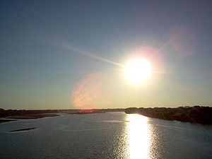 Sunset over the Lempa river
Countries El Salvador, Honduras, Guatemala Source Sierra Madre - location Olopa, Chiquimula, Guatemala - elevation 1,200 m (3,937 ft) - coordinates 14°41′33″N 89°18′18″W / 14.6925°N 89.305°W Mouth Pacific Ocean - location El Playón, Tecoluca, San Vicente, El Salvador - elevation 0 m (0 ft) - coordinates 13°15′17″N 88°49′38″W / 13.25472°N 88.82722°W Length 422 km (262 mi) Basin 18,246 km2 (7,045 sq mi) Discharge for Cuscatlan bridge[1] - average 362 m3/s (12,784 cu ft/s)  Railroad Bridge (FENADESAL) over the Lempa river, as seen from the Carretera del Litoral highway bridge (El Salvador)
The Lempa River (Spanish: Río Lempa) is a 422 km long river in Central America.[2] Its sources are located in between the Sierra Madre and the Sierra del Merendón in southern Guatemala, near the town of Olopa.[2] In Guatemala the river is called Río Olopa and flows southwards for 30.4 km before entering Honduras and changing its name to Lempa river at 14°32′52″N 89°15′50″W / 14.547700°N 89.264002°W. In Honduras it flows through Ocotepeque Department for 31.4 km, and crosses the border with El Salvador at the town of Citalá (14°22′19″N 89°12′45″W / 14.371857°N 89.212439°W) in the department of Chalatenango. The river continues its course for another 360 km in El Salvador, flowing in a generally southwards direction until it reaches the Pacific Ocean in the department of San Vicente.[2][3] The river forms a small part of the international boundary between El Salvador and Honduras.
The river's watershed has an extension 18,246 km², of which 10,255 km2 (56%) is situated in El Salvador, 5,696 km2 in Honduras and 2,295 km2 in Guatemala.[1] 49% of El Salvador's territory is covered by the Lempa river basin,[1] and 77.5% of the Salvadoran population lives in cities, towns, and villages that are located in its basin, including the capital city of San Salvador.[3]
Hydroelectricity
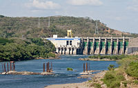 15 de Septiembre Hydroelectric dam over the Rio Lempa, El Salvador
There are several hydroelectric dams along the river. In El Salvador there is the Guayojo dam, the Cerrón Grande Hydroelectric Dam, the 5 de Noviembre dam, and the 15 de Septiembre dam which can be easily seen from the Pan-American highway.
References
- ^ a b c "Water Resources Assessment of El Salvador" (pdf). United States Army Corps of Engineers (USACE). 1998. http://www.sam.usace.army.mil/en/wra/ElSalvador/El%20Salvador%20WRA%20English.pdf. Retrieved 2009-05-04.
- ^ a b c Hernández, Walter (2005). "Nacimiento y Desarrollo del río Lempa" (pdf). San Salvador: Servicio Nacional de Estudios Territoriales (SNET). http://www.snet.gob.sv/Geologia/NacimientoEvolucionRLempa.pdf. Retrieved 2009-05-03.
- ^ a b "Mapas de Recursos Hídricos". San Salvador: Servicio Nacional de Estudios Territoriales (SNET). http://snet.gob.sv/cd2/SeccionSIG/map_hi.htm. Retrieved 2009-05-03.[dead link]
Categories:- Rivers of El Salvador
- Rivers of Guatemala
- Rivers of Honduras
- International rivers of North America
- El Salvador–Honduras border


Wikimedia Foundation. 2010.