- Kundapura
-
Kundapura (ಕುಂದಾಪುರ) — town — Clockwise from top: Kundapur River, Main Road, Kollur Mookambika temple, Shastri Circle, Anegudde Sri Vinayaka Temple, Coconut Tree.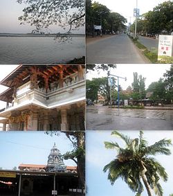 Kundapura Town
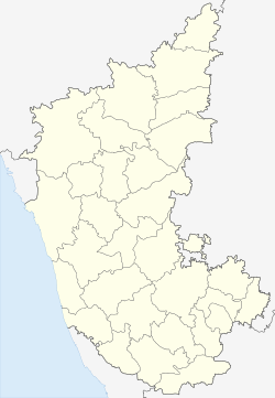

 Kundapura (ಕುಂದಾಪುರ)
Coordinates 13°48′N 74°42′E / 13.80°N 74.7°ECoordinates: 13°48′N 74°42′E / 13.80°N 74.7°E Country India State Karnataka District(s) Udupi Settled 1912 Headquarters Udupi Nearest city Udupi, Brahmavara Counciller Deputy Counciller Legislature (seats) Bicameral () Parliamentary constituency Udupi Loksabha Constituency(15th) Assembly constituency Kundapura Vidhansabha Kshethra(124th) Zone Kundapura Municipality Kundapura Town Municipal Council Population
• Density
28,595 (2001[update])
• 2,415.11 /km2 (6,255 /sq mi)
Sex ratio 1.09 ♂/♀ Time zone IST (UTC+05:30) Area
23.06 square kilometres (8.90 sq mi)
• 80 metres (260 ft)
Website Kundapura Town Municipal Council Kundapura (Kannada: ಕುಂದಾಪುರ) is a town in Udupi district in the Indian state of Karnataka. It is the headquarters of the Kundapura taluk and is about 36 km (22 mi) from Udupi.
Contents
History
 Kodi Beach at Kundapura
 View from Kundapura Light House
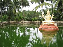 Lake near Sri Kundeshwara Temple
 Anegudde Sri Vinayaka Temple, Kumbashi
The name Kundapura can be traced to the Kundeshvara temple built by Kundavarma in the vicinity of the Panchagangavalli river The name of the town may be derived from Kundavarma who ruled the area. Kunda means 'pillar' in Kannada,[1] which refers to the traditional method of constructing houses. Pura means town. Kundapura is surrounded by water from three sides. To the north lies the Panchagangavali river. To the east lies the Kalaghar river. To the west lie the Kodi back waters and the Arabian Sea, leaving the south side as the main connecting land mass. All connecting roads to Kundapura enter the city from southern direction. Northside of the town is vast backwaters of Panchagangavali river and it can be crossed by boat only.
Access
Kundapura is well connected to other parts of the country by National Highway -17. Kundapura is also connected by the Konkan Railway, which runs from Mumbai to Mangalore. Kundapura railway station is about 4 kilometres (2.5 mi) from the town. The nearest airport is Mangalore International Airport, situated at Bajpe around 100 kilometres (62 mi) from Kundapura. While a national highway connects this town to Karwar, Mangalore, Udupi etc., a state highway also connects Kundapura to Shimoga and further onwards to Bangalore. One can alight at Kundapura railway station to travel 40 kilometres (25 mi) to the Shri Mookambika Devi temple at Kollur.
From kundapura to sagar is 150 km to udupi is 36 km to shimoga is 140km
Demographics
As of 2001[update] India census,[2]
- Kundapura had a population of 28,595.
- Males constitute 49% of the population and females 51%.
- Literacy rate of 92%, higher than the national average of 59.5%: male literacy is 94%, and female literacy is 88%.
- 9% of the population is under 6 years of age.
 River behind Kundapur bus stop
.
Languages and culture
The town mainly consists of Kannadigas who speak Kundagannada, Konkanis and Tuluvas. The Goud Saraswat Brahmins who fled Goa during the Portuguese arrival in the 16th century arrived by Boat in Basrur and some settled in Kundapura and surrounding villages. These people and Kudubi tribe speak Konkani Language. Otherwise, a dialect of Kannada called Kundaganna or Kundapura Kannadais predominently spoken in Kundapura town and Kundapura Taluk .But Tulu is also spoken here and there( by less than 5% of the population ), mainly by those who have migrated from Udupi/Mangalore.
Places of interest in Kundapura taluk
- Kundeswara temple Kundapur gets its name from the this temple built by Kundavarma.
- Sri Vinayaka (Ganesh) Temple at Anegudde, between Kota, Udupi and Koteshwar towns. The temple is located 5 kilometres (3.1 mi) from Kundapura. Among the several temples in Kumbhashi Anegudde, Sri Vinayaka Temple is the oldest, and it is also the most popular in this region. This Ganesh temple is on a small hillock, giving the name Anegudde, "Ane" meaning elephant and "Gudde" meaning a hillock.
- Mekekattu Nadhikeshwara temple is an historical place. Located about 20 kilometres (12 mi) from Kundapura, it falls within the limits of Udupi Taluk, but is culturally connected to Kundapura. It is nearer to Barkuru in the Shiriyara village. Legend says it is a creation of sage Parashurama as applicable to all places of Coastal Karnataka. With the passage of time the area where the temple is situated has been called by different names. It attracts several visitors every year, particularly during annual festival, hasara, and sedi. Striking feature of Mekkekattu temple include a large collection of coloured, wooden idols, some of which measure up to 10 feet in height. Most of the wooden statues are in warrior dress, giving an impression that this entire row of wooden statues are made to remember an incidence of war that would have taken place here during 1600-1700 AD (no historic evidence for this war is found yet, but can be linked to Mogul / Bahamani Invasion). Some of the statues are like Muslim soldires, some like maratha soldiers. Some even hold a replica of an old gun or swords, posed as if ready for war. All wooden statues are given local mythological names. Yettinahatti, very near to Mekke kattu, is an interesting place where bulls are worshiped, and may have some historical links with Mekke Kattu. There is one more small place called Karuvina Hatti about 35 kilometres (22 mi) from Udupi via Brahmavara – Barkur,Shiriyara
- Guddattu Vinayaka temple This particular temple, situated in the border area of Kundapur and Udupi taluks, has to been seen to be believed. Guddattu is a place of natural beauty. The History of Guddattu Sri Vinayaka Temple runs back for about 1700 years. The natural rock formation similar to Ganesh Idol is inside a small cave and the natural formation of cave is such that, around thousand Koda of water collects naturally and submerges the Ganesh Idol. It is said that the three foot idol of Lord Vinayaka was emerged by itself, attaching to a big rock. The black and grey stone structure of Lord Ganapathi is in a sitting position. His trunk is towards the right, eyes and legs clearly visible. The pooja of Ayarkoda is performed by devotees with much faith and devotion. The new rock Temple is constructed here, adjacent to a huge granite rock, which looks like a sleeping elephant. This temple is about 35 kilometres (22 mi) from Udupi via Brahmavara – Barkur, Shiriyara, about 15 kilometres (9.3 mi) from Kundapur via Koteshwara – Hunsemakhi -Guddeangady.
- Padukone is a coastal village located approximately 17 kilometres (11 mi) north of the taluk center. Part of the village is surrounded by the Souparnika River and one has to cross this river in an old wooden boat from Maraswami. Padukone is a beautiful village surrounded by coconut trees, water, and kudru.
- Basrur - Many temples are located here on the southern banks of the Varahi River. Historically, Basrur is the main and center place of Kundapura Taluk. This area has many historical structures. Traders from foreign countries used to bring their boats and ships to Basrur, which is a natural harbour, and trade their goods for pepper and good quality rice. During 19th and 20th centuries, this place was famous for a singing and dancing lady community and such ladies devoted their lives to singing, entertainment and mainly attending the fancy and needs of rich gentlemen of the area.
- Uppinakudru - Uppinakudru, or salt island, is located 6 kilometres (3.7 mi) north of Kundapura which is a taluk headquarters in Udupi District.
- Hoovinakere - It is the birthplace of the philosopher Vadiraja, who preached Dvaita philosophy after Madhvacharya.
- Koteshwara - The Koteshwara temple is an historical and religious centre. Here the lake adjacent to the temple is larger than the main temple. One of the many legends about this lake is that there is an underground tunnel to Vandaru Kambala Gadde which is at a distance of 20 kilometres (12 mi). The Pattabhiramachandra temple, Mariyamma Temple, and the Kodandarama Temple are located in the same place.[citation needed]
- Hattiangadi has another well-known temple of Lord Ganapathi, and many other ancient temples besides.
- GOPADY-small village located between Koteshwara and Kumbhashi.Kantheshwara temple is the temple where one can see the"Udhbhava Linga".Gopady has a beautiful sea shore and a "Guest house" near sea where people from far off places come and stay.
Kirimanjeshwara - Located about 22 kilometres (14 mi) from Kundapur, it has the Kirimanjeshwara temple amidst beautiful surroundings. There is another old temple called the Agastyeshwara temple, named after Sage Agastya.
- Shankaranarayana - Located about 32 kilometres (20 mi) to the east of Kundapur, it is traditionally called Krodha Kshetra and is one of the seven places of pilgrimage in the region mentioned in the Skanda Purana.
- Trasi - Located about 12 kilometres (7.5 mi) to the North of Kundapur, Trasi has a beautiful 1 kilometre (0.62 mi) long beach with Turtle Bay and Beach Resort.
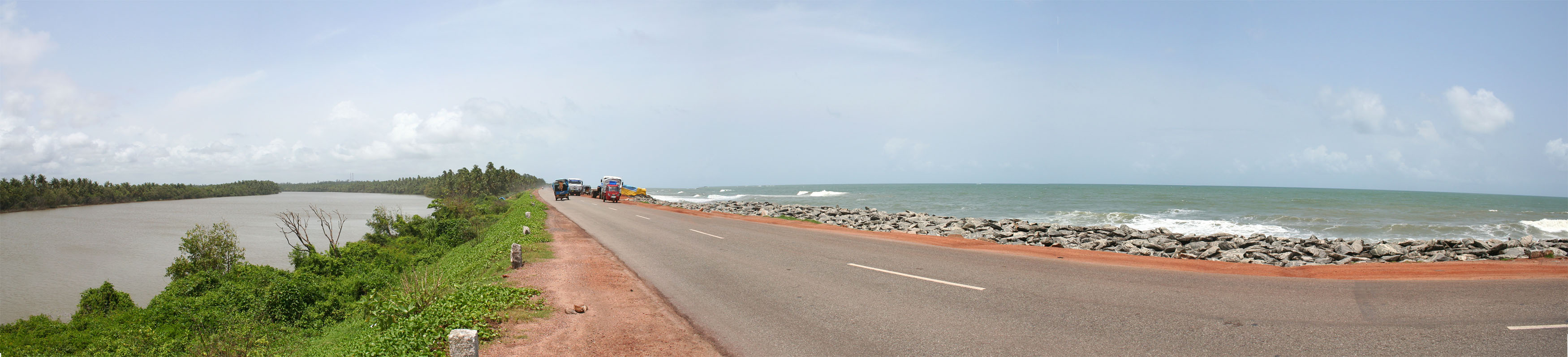
 NH17 near Maravanthe
- Maravanthe - One of Karnataka's most beautiful beaches. It is about 55 kilometres (34 mi) from Udupi. NH-17 runs right next to the beach and the Suparnika River flows on the other side of the road, creating a spectacular scenery and considered only one of its kind in India. The river Souparnika, which almost touches Arabian Sea here, makes a U turn and goes eastward to join the Sea only after a journey of more than 10 kilometres (6.2 mi), which is a geological wonder.
- Kollur is one of the Shakti Pithas established by Shankaracharya. Souparnika river flows here in the midst of dense forest. Kodachadri hill, with a height of about 3,800 feet (1.2 km) at the backdrop, is a suitable trekking spot. Trekkers can start trekking from Nagodi village near Kollur and reach Kodachadri peak after about three hours. Thick forest, sholas, grass lands, and cool air are a specialty of this place. There is a moola stana of Kollur Goddess at Kodachadri. An iron pillar, said to be an ancient weapon used by Goddess Mookambika to kill the demon Kolasura, stands in front of a small temple near Travelers Bungalow. The antiquity of this iron pillar makes for an interesting sight. Sunset from Kodachadri Peak during winter is a rather spectacular sight. There is a traveller's bungalow, and other facilities are rudimentary. Those who want to stay overnight should be prepared for basic facilities at minimal.
- Ottinene - This is a sunset point on the seashore, near Byndoor village on the national highway. The Kshitija Nature Resort, a beach and sunset point, are favorite spots with travelers here. Byndoor is a village near the sea.
- Kodi Beach This is a nice beach located about 4 kilometres (2.5 mi) from Kundapur. The Kinara Restaurant is a nice place to spend the time, while enjoying the beauty of the Arabian Sea.
- Bhandarkars college is a first grade university located in Kundapura. The college campus with adjacent cricket ground makes for a good sight.
- Kannadakudru It is a small island located in the middle of Gangolli, Uppinakudru, Hemmadi and Arate Bridge. Here, most of the people are farmers and grow only coconut & in rainy season paddy/Rice. This village is surrounded by salt water, which invades the river at high tide from the Arabean Sea. The landscape here is beautiful. Kudru means island; but how Kannad got joined to the name of the village is very interesting, and Kannada is the local language spoken.
- Gangolli, even though very near to Kundapura, one has to travel more than 15 kilometres (9.3 mi) to reach this place as Panchagangavali River separates this from Kundapura town. One can also take boat ride, which depends on high tide timings. This is a beautiful place located at bank of five rivers and Arabian Sea. Fishing is the main activity. Veereshwara Temple is one of the oldest temples of Gangolli.
- Rattadi This place is between Halady and Amasebail. Named after god `Ratteshwara`, this is a small village near western ghats. Thick forests surround this village.
- Maranakatte This is a place located at a distance of about 18 kilometres (11 mi) from Kundapura and known for its Temple of "Sri Bramhalingeshwara", which is located in the bank of river Souparnika. It has a mythological connection with the Kollur "mookambika" temple, this being the place where the Goddess of Kollur killed Mookasura, the Rakshasa. Adi Shankaracharya visited this place and stopped tantrik rituals, and established Sri Chakra, as recorded on a plaque available inside the temple. Maranakatte is a beautiful place, as it is surrounded by thick forest and paddy fields.
- Halady, a village at a distance of 22 kilometres (14 mi) from Kundapura town, is known mainly as a junction of roads leading to Shankaranarayana, Amasebail and Hebri. Halady River surrounds this village to the north. An old Tiles factory was busy burning red tiles up to the 1980s in Halady, but this industry has become obsolete and outdated because of dwindling forest cover, from where the logs were supplied to bake tiles and less demand for tiles in view of RCC houses. The Marlu chicku is one deity of Halady which attracts a large number of people, and another temple is of Laxmi Narasimha with seven foot stone statue. The river in front of this temple is a beautiful scene. Varahi Lift Irrigation Project work is going on in this area.
- Vakwadi This is a small village located between Anegudde and Huvinakere and about 2 kilometres (1.2 mi) from Koteswara. A temple of Mahalingeshwara about 2 kilometres (1.2 mi) from Anegudde is a place where forest, meadows, and trees make for an excellent view.
- BidkalkatteThis is a small village near Halady. It has a government-funded high school, college, and hospital. This is on the state highway kundapur-shimoga & udupi-shimoga.
- MolahalliThis is a small village near Bidkalkatte and known as birth place of 'Sahakari Pithamaha' M.Shivarao. Shivaraya temple is located in this place. This village hosts a Kambala every winter, which is visited by surrounding villagers.
- HERIKUDRU This is river island near Kundapur. This island well connected with NH17. There is one more subisland near this called Kamastar Kuru.
References
- ^ Kittel, Ferdinand (1999). A Kannada-English dictionary. Asian Educational Services. p. 441. ISBN 8120600495. http://books.google.com/books?id=HBUsaxC61mkC&pg=RA3-PA441#v=onepage&q=&f=false.
- ^ "Census of India 2001: Data from the 2001 Census, including cities, villages and towns (Provisional)". Census Commission of India. Archived from the original on 2004-06-16. http://web.archive.org/web/20040616075334/http://www.censusindia.net/results/town.php?stad=A&state5=999. Retrieved 2008-11-01.
 Udupi District Topics
Taluks Kundapura · Udupi · Karkala ·Places Udupi • Brahmavara • Kundapura • Kalyanpura • Manipal • Karkala • Saligrama • Kemmannu • Anegudde • Baindur • Greater Udupi • Hattiangadi • Hebri • Hemmadi • Hiriadka • Hoovinakere • Kunjarugiri • Katapady • Kaup (village) • Malpe • Vandse • Shiroor • Kollur • Nitte • Padubidri • Pajaka • Palimar • Pangala • Shankaranarayana • Shankarapura • Shirva • Tonse • Uchila • Udyavara • Yennehole • Yermal •Temples Udupi · Mookambika · Shringeri · Dharmasthala · Kukke Subramanya · Nellitheertha · Kollur · Kateel · Anegudde · Padutirupathi ·Udupi cuisines Society Beaches Kaup (village) · Mukka · Panambur · Ullal · Trasi · Tannirubhavi Beach · Maravanthe · Kudle beach · St. Mary's IslandsCategories:- Railway stations on Konkan Railway
- Cities and towns in Udupi district


Wikimedia Foundation. 2010.