- United States National Radio Quiet Zone
-
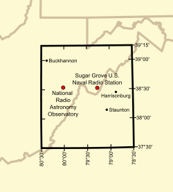 The National Radio Quiet Zone spans West Virginia, Virginia, and a small part of Maryland.
The United States National Radio Quiet Zone is a large area of land surrounding the National Radio Astronomy Observatory (NRAO) at Green Bank, West Virginia, and especially the large Green Bank Telescope radio telescope. The Radio Quiet Zone is a rectangle of land approximately 13,000 square miles (34,000 km2) in size that straddles the border area of Virginia and West Virginia. It includes all land with latitudes between 37.5°N and 39.25°N and longitudes between 78.5°W and 80.5°W. This area was chosen because it has a hilly topography that screens out most incoming radio signals, allowing the Green Bank telescopes to receive signals that are otherwise too low in power to be heard over the normal radio background in North America.
The National Radio Quiet Zone also protects the antennas and receivers of the U.S. Navy Information Operations Command (NIOC) at Sugar Grove, West Virginia.[1] The NIOC at Sugar Grove has long been the location of electronic intelligence gathering systems, and is today said to be a key station in the ECHELON system operated by the National Security Agency (NSA).[2]
The Radio Quiet Zone was established by the Federal Communications Commission (FCC) in 1958 to protect the observatory's radio telescopes from harmful interference. Omnidirectional and high-power transmissions are very restricted. Furthermore, fixed radio links are often built as tight-beamed directional links that do not illuminate the sensitive radio telescopes and electronic intelligence-gathering stations there.
Not all radio transmissions are prohibited in the Radio Quiet Zone. For example Citizen's Band radios, police and ambulance radios, and fire department radios are used there. However, large radio transmitter owners must typically coordinate their operations with representatives of the National Radio Astronomy Observatory and the U.S. Department of Defense. The Allegheny Mountain Radio company operates the only broadcast radio stations in the inner core of the Quiet Zone, with just one station in the AM band, and several low-power FM stations. Most radio transmitters within the area are licensed by the FCC (just as they are in the rest of the United States). Exceptions to the Radio Quiet Zone restrictions are usually determined on a case-by-case basis, with preference given to public safety concerns, such as remote alarm systems, repeaters for first responders, and NOAA Weather Radio. Due to the restrictions, the area has attracted people who believe they suffer from Electromagnetic hypersensitivity.[3]
Contents
Counties inside the Zone
Maryland
- Extreme southern Garrett County
Virginia
- Western Albemarle County
- Alleghany County
- Amherst County, except for the southern quarter
- Extreme northern Appomattox County
- Augusta County
- Bath County
- Extreme northern Bedford County
- Northern Botetourt County
- Northwestern Buckingham County
- Northern Craig County
- Western Greene County
- Highland County
- Nelson County
- Western Page County
- Rockbridge County
- Rockingham County, except for a small area in the extreme eastern part
- Western Shenandoah County
West Virginia
- Barbour County, except for a small area in the north
- Extreme eastern Braxton County
- Grant County, except for an area in the north
- Eastern Greenbrier County
- Southwestern Hampshire County
- Hardy County
- Southeastern Harrison County
- Eastern Lewis County
- Extreme southern Mineral County
- Northeastern and east central Monroe County
- Extreme eastern Nicholas County
- Pendleton County
- Pocahontas County
- Two areas in extreme southwestern and southeastern Preston County
- Randolph County
- Extreme southern Taylor County
- Tucker County, except for an area in the extreme northern part
- Upshur County
- Central and eastern Webster County
Cities inside the Zone
Virginia
- Buena Vista
- The western half of Charlottesville, including much of the University of Virginia Grounds
- Covington
- Harrisonburg
- Lexington
- Staunton
- Waynesboro
West Virginia
Clarksburg, West Virginia, and Lynchburg, Virginia, are just outside the Quiet Zone.
References
- ^ Beaudet, Carla (1 November 2010). "National Radio Quiet Zone". Charlottesville, VA, USA: National Radio Astronomy Observatory (NRAO). http://www.gb.nrao.edu/nrqz/nrqz.shtml. Retrieved 14 September 2011.
- ^ "Interception Capabilities 2000, Sugar Grove, Virginia - COMSAT interception at ECHELON site". Interception of Communications Section. Leeds, UK: Cyber-Rights & Cyber-Liberties (UK). May 11, 1999. Archived from the original on May 30, 2008. http://www.fas.org/irp/eprint/ic2000/ic2000.htm#_Toc448565544. Retrieved September 14, 2011. "Interception Capabilities 2000 Report to the Director General for Research of the European Parliament (Scientific and Technical Options Assessment programme office) on the development of surveillance technology and risk of abuse of economic information."
- ^ O'Brien, Jane; Danzico, Matt (September 12, 2011). "'Wi-fi refugees' shelter in West Virginia mountains". BBC News. http://www.bbc.co.uk/news/world-us-canada-14887428. Retrieved September 13, 2011.
External links
Categories:- United States communications regulation
- Communications in West Virginia
- West Virginia media

Wikimedia Foundation. 2010.