- Chuguyevsky District
-
For the district in Kharkiv Oblast, Ukraine, see Chuhuivskyi Raion.
Chuguyevsky District (English)
Чугуевский район (Russian)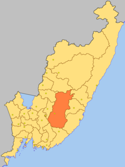
Location of Chuguyevsky District on the map of Primorsky KraiCoordinates: 44°28′N 134°12′E / 44.467°N 134.2°ECoordinates: 44°28′N 134°12′E / 44.467°N 134.2°E 
Coat of arms of Chuguyevsky Municipal District Administrative status (as of 2009) Country Russia Federal subject Primorsky Krai[1] Administrative center selo of Chuguyevka[citation needed] # of rural localities 32[1] Municipal status (as of June 2010) Municipally incorporated as Chuguyevsky Municipal District[2] - # of rural settlements 3[2] Statistics Area 12,346.5 km2 (4,767.0 sq mi)[3] Population (2002 Census) 28,913 inhabitants[4] - Urban population 0% - Rural population 100% Population (2010 est.) 25,217 inhabitants[5] Density 2 /km2 (5.2 /sq mi)[6] Time zone VLAST (UTC+11:00)[7] Official website Chuguyevsky District (Russian: Чугу́евский райо́н) is an administrative[1] and municipal[2] district (raion) of Primorsky Krai, Russia; one of the twenty-two in the krai. It is located in the central portion of the krai. The area of the district is 12,346 square kilometers (4,767 sq mi).[3] Its administrative center is the rural locality (a selo) of Chuguyevka. District's population: 25,217 (2010 est.);[5] 28,913 (2002 Census);[4] 30,909 (1989 Census).[8] Population of Chuguyevka accounts for 47.3% of the district's population.[4]
Municipally, the district is divided into three rural settlements comprising thirty-two rural localities.[2]
The territory is rugged by the ranges and spurs of Sikhote-Alin mountain system and almost totally covered with forests and bushes mainly of coniferous-deciduous kind. There is a game reserve in the territory of the district which is remarkable for its highland landscape with specific fauna and endemic insect species. In 2007, Zov Tigra (lit. Call of the Tiger) national park based on this game preserve was established in the district.
There is a large deposit of perlite and vermiculite which can be used as a filler in a concrete-processing industry. A zeolite deposit is exploited in the district. There are stocks of the gravel-sand mixture and pebble, and a unique deposit of decorative collectible stones.
The district's industry is represented by the krai's largest timber industry enterprises which are involved in commercial timber processing, sawtimber, and technological wood chips and plywood production. Development and utilization of perlites, zeolites, and vermiculites as well as forest food resources are considered prospective.
Agriculture is specialized in potato growing, milk and meat cattle breeding. The arable area comprises some western part of the district, with its rich alluvial soils of the upper to middle valleys of the Ussuri River.
References
- ^ a b c Law #161-KZ, Appendix
- ^ a b c d Law #147-KZ
- ^ a b Официальный сайт Законодательного Собрания Приморского края. Сборник "Муниципальные образования Приморского края" (Official website of the Legislative Assembly of Primorsky Krai. Municipal Formations of Primorsky Krai) (Russian)
- ^ a b c Федеральная служба государственной статистики (Federal State Statistics Service) (2004-05-21). "Численность населения России, субъектов Российской Федерации в составе федеральных округов, районов, городских поселений, сельских населённых пунктов – районных центров и сельских населённых пунктов с населением 3 тысячи и более человек (Population of Russia, its federal districts, federal subjects, districts, urban localities, rural localities—administrative centers, and rural localities with population of over 3,000)" (in Russian). Всероссийская перепись населения 2002 года (All-Russia Population Census of 2002). Federal State Statistics Service. http://www.perepis2002.ru/ct/doc/1_TOM_01_04.xls. Retrieved 2010-03-23.
- ^ a b Федеральная служба государственной статистики (Federal State Statistics Service). Численность постоянного населения Российской Федерации по городам, посёлкам городского типа и районам на 1 января 2010 г. (Permanent Population of the Russian Federation by Cities/Towns, Urban-Type Settlements, and Districts as of January 1, 2010) (Russian)
- ^ The value of density was calculated automatically by dividing the 2002 Census population by the area specified in the infobox. Please note that this value may not be accurate as the area specified in the infobox does not necessarily correspond to the area of the entity proper or is reported for the same year as the population.
- ^ Правительство Российской Федерации. Постановление №725 от 31 августа 2011 г. «О составе территорий, образующих каждую часовую зону, и порядке исчисления времени в часовых зонах, а также о признании утратившими силу отдельных Постановлений Правительства Российской Федерации». Вступил в силу по истечении 7 дней после дня официального опубликования. Опубликован: "Российская Газета", №197, 6 сентября 2011 г. (Government of the Russian Federation. Resolution #725 of August 31, 2011 On the Composition of the Territories Included into Each Time Zone and on the Procedures of Timekeeping in the Time Zones, as Well as on Abrogation of Several Resolutions of the Government of the Russian Federation. Effective as of after 7 days following the day of the official publication).
- ^ "Всесоюзная перепись населения 1989 г. Численность наличного населения союзных и автономных республик, автономных областей и округов, краёв, областей, районов, городских поселений и сёл-райцентров. (All Union Population Census of 1989. Present population of union and autonomous republics, autonomous oblasts and okrugs, krais, oblasts, districts, urban settlements, and villages serving as district administrative centers.)" (in Russian). Всесоюзная перепись населения 1989 года (All-Union Population Census of 1989). Demoscope Weekly (website of the Institute of Demographics of the State University—Higher School of Economics. 1989. http://demoscope.ru/weekly/ssp/rus89_reg.php. Retrieved 2010-03-23.
Sources
- Законодательное Собрание Приморского края. Закон №161-КЗ от 14 ноября 2001 г. «Об административно-территориальном устройстве Приморского края», в ред. Закона №816-КЗ от 6 октября 2011 г «О внесении изменений в приложение к Закону Приморского края "Об административно-территориальном устройстве Приморского края"». Вступил в силу со дня официального опубликования. Опубликован: "Красное знамя Приморья", №69 (119), 29 ноября 2001 г. (Legislative Assembly of Primorsky Krai. Law #161-KZ of November 14, 2001 On the Administrative-Territorial Structure of Primorsky Krai, as amended by the Law #816-KZ of October 6, 2011 On Amending the Appendix of the Law of Primorsky Krai "On the Administrative-Territorial Structure of Primorsky Krai". Effective as of the official publication date).
- Законодательное Собрание Приморского края. Закон №147-КЗ от 11 октября 2004 г. «О Чугуевском муниципальном районе», в ред. Закона №636-КЗ от 29 июня 2010 г «О преобразовании некоторых сельских поселений Чугуевского муниципального района Приморского края и о внесении изменений в Закон Приморского края "О Чугуевском муниципальном районе"». Вступил в силу со дня официального опубликования. Опубликован: "Ведомости Законодательного Собрания Приморского края", №70, 14 октября 2004 г. (Legislative Assembly of Primorsky Krai. Law #147-KZ of October 11, 2004 On Chuguyevsky Municipal District, as amended by the Law #636-KZ of June 29, 2010 On the Transformation of Several Rural Settlements of Chuguyevsky Municipal District of Primorsky Krai and on Amending the Law of Primorsky Krai "On Chuguyevsky Municipal District". Effective as of the day of the official publication).
Administrative divisions of Primorsky Krai Cities and towns Arsenyev · Artyom · Bolshoy Kamen · Dalnegorsk · Dalnerechensk · Fokino · Lesozavodsk · Nakhodka · Partizansk · Spassk-Dalny · Ussuriysk
Urban-type settlements Dunay · Gornorechensky · Gorny · Gornye Klyuchi · Kavalerovo · Khasan · Khrustalny · Kirovsky · Kraskino · Lipovtsy · Luchegorsk · Novoshakhtinsky · Olga · Plastun · Pogranichny · Posyet · Preobrazheniye · Primorsky · Putyatin · Rudny · Shkotovo · Sibirtsevo · Slavyanka · Smolyaninovo · Svetlaya · Terney · Vostok · Vysokogorsk · Yaroslavsky · ZarubinoDistricts Anuchinsky · Chernigovsky · Chuguyevsky · Dalnerechensky · Kavalerovsky · Khankaysky · Khasansky · Khorolsky · Kirovsky · Krasnoarmeysky · Lazovsky · Mikhaylovsky · Nadezhdinsky · Oktyabrsky · Olginsky · Partizansky · Pogranichny · Pozharsky · Shkotovsky · Spassky · Terneysky · YakovlevskyCategories:- Districts of Primorsky Krai


Wikimedia Foundation. 2010.