- Pennsylvania Route 21
-
"PA 21" redirects here. PA 21 may also refer to Pennsylvania's 21st congressional district.
PA Route 21

Route information Maintained by PennDOT Length: 50.5 mi[1] (81.3 km) Existed: 1928 – present Major junctions West end:  WV 891 in Richhill Township
 US 19 in Waynesburg
 I-79 in Morrisville

 US 40/US 119 in Uniontown
East end: 
US 40 BUS in UniontownLocation Counties: Greene, Fayette Highway system Roads in Pennsylvania
Interstate • US • State • Legislative←  US 20
US 20US 22  →
→Pennsylvania Route 21 is a 50.5-mile (81.3 km) long east–west state highway in the US state of Pennsylvania. The western terminus of the route is at the West Virginia state line in Richhill Township, where PA 21 continues into West Virginia as West Virginia Route 891. The eastern terminus is at U.S. Route 40 Business in Uniontown. The route is known as the Roy E. Furman Highway for most of its length.
Contents
Route description
Greene County
Pennsylvania Route 21 enters Greene County in Richhill Township near the village of Polen. The highway winds its way through the hilly and sparsely populated area passing Ryerson Station State Park to the north. It continues to the northeast into Gray Township where it veers to the southeast toward the village of Rogersville in Center Township. Just before reaching Rogersville, Route 21 merges with Pennsylvania Route 18 near West Greene High School. Route 18 leaves Route 21 near West Waynesburg while Route 21 continues into the borough of Waynesburg.[2]
In Waynesburg, PA 21 is a one-way pair as High Street (west) and Greene Street (east). Both streets are two lanes in the borough. High Street is the arterial road through Waynesburg's business district. While in Waynesburg, it shares its route with U.S. Route 19. PA 21 leaves Waynesburg entering the census-designated place of Morrisville. PA 21 becomes a two-lane road with a shared left turn lane for less than a mile before US 19 leaves the route and PA 21 stays east, becoming a four lane divided highway. Interstate 79 exit 14 is PA 21 in Morrisville signed for PA 21 to Masontown and Waynesburg. PA 21 then leaves Morrisville in Jefferson Township.[3]
PA 21 travels east-southeast through the rest of rural Greene County. The road is mostly level and the countryside is mostly farmland. In Paisley, PA 21 intersects with Pennsylvania Route 88 at a busy intersection, then becomes a four-lane divided highway until it reaches Hatfield Ferry Power Station and the Masontown Bridge over the Monongahela River.[4]
Fayette County
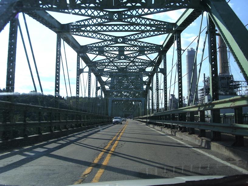
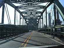 PA 21 traveling west across the Masontown Bridge
PA 21 enters Fayette County in the borough of Masontown. It bypasses Masontown to the north and merges with PA 166 (Main St.). After leaving Masontown, the southernmost point on the route, PA 21 becomes McClellandtown Road. It turns to the northeast entering German Township and leaving PA 166. Passing through McClellandtown, PA 21 traverses more densely populated western Fayette County entering South Union Township.[5]
The highway enters South Union Township in the village of Uledi. It intersects with Dixon Boulevard before entering the city of Uniontown. It has an interchange with U.S. Route 40/U.S. Route 119 near Cherry Tree Square. It also passes Fayette County's main shopping district and Uniontown Hospital before ending at US Route 40 Business (Main St.).[6]
History
Pennsylvania Route 21 was first signed in 1928. It was first paved from the West Virginia state line to Ryerson in 1929. Originally, the highway was routed to Carmichaels. In 1953, it was realigned onto its current route from George St. in Cumberland Township to Uniontown. PA 21 has been widened several times and several medians have been installed due to increased use since the 1950s.[7] Improvements, including a new bridge over the Monongahela River, are in the plans for the future.[8]
Major intersections
County Location Mile Destinations Notes Greene Richhill Township 0.0[1] WV 891Western terminus, continues as WV 891 Center Township 16.7  PA 18 south
West end of PA 18 concurrency Waynesburg 22.6 PA 18 northEast end of PA 18 concurrency 23.4 US 19 north (Morris Street)West end of US 19 concurrency 23.7  PA 218 (Morris Street)
Northern terminus of PA 218 24.8 US 19 south (High Street)East end of US 19 concurrency 24.9  PA 188 (Morris Street)
Western terminus of PA 188 Franklin Township 25.8 I-79Exit 14 (I-79) Cumberland Township 37.3  PA 88
PA 88Fayette Masontown 40.4  PA 166 south (Main Street)
West end of PA 166 concurrency German Township 41.6 PA 166 northEast end of PA 166 concurrency Uniontown 49.4 US 40 / US 119Trumpet interchange 50.5
US 40 Bus. (Main Street)Eastern terminus 1.000 mi = 1.609 km; 1.000 km = 0.621 mi See also
References
- ^ a b Google, Inc. Google Maps – PA 21 Overview (Map). Cartography by Google, Inc. http://maps.google.com/maps?f=d&saddr=PA+21+and+WV+891&daddr=PA+21+and+US+40,+Uniontown,+PA&hl=en&geocode=&mra=ls&sll=39.938172,-80.37735&sspn=0.398541,0.615234&ie=UTF8&ll=39.908683,-80.095825&spn=0.797421,1.230469&z=10. Retrieved 2008-08-18.
- ^ Google, Inc. Google Maps – PA 21 in Western Greene County (Map). Cartography by Google, Inc. http://maps.google.com/maps?f=d&saddr=PA+21+and+WV+891&daddr=West+Waynesburg,+PA&hl=en&geocode=&mra=ls&sll=39.908683,-80.095825&sspn=0.797421,1.230469&ie=UTF8&ll=39.896831,-80.368767&spn=0.199391,0.43808&z=12. Retrieved 2008-08-18.
- ^ Google Maps. PA 21 in Waynesburg (Map). http://maps.google.com/maps?f=d&saddr=West+Waynesburg,+PA&daddr=417+E+Roy+Furman+Hwy+%23+203,+Waynesburg,+PA+15370+(County+of+Greene:+District+13-2-02)&hl=en&geocode=%3B12865745746169391241,39.898477,-80.134613&mra=pe&mrcr=0&sll=39.89986,-80.167065&sspn=0.099691,0.153809&ie=UTF8&ll=39.89907,-80.169897&spn=0.049846,0.10952&z=14. Retrieved 2008-08-18.
- ^ Google Maps. PA 21 in Eastern Greene County (Map). http://maps.google.com/maps?f=d&saddr=417+E+Roy+Furman+Hwy+%23+203,+Waynesburg,+PA+15370+(County+of+Greene:+District+13-2-02)&daddr=Mt.+Sterling,+PA&hl=en&geocode=12865745746169391241,39.898477,-80.134613%3B&mra=ls&sll=40.138225,-79.901134&sspn=0.794746,1.230469&ie=UTF8&ll=39.883923,-80.028706&spn=0.199429,0.43808&z=12. Retrieved 2008-08-18.
- ^ Google, Inc. Google Maps – PA 21 in Western Fayette County (Map). Cartography by Google, Inc. http://maps.google.com/maps?f=d&saddr=Mt.+Sterling,+PA&daddr=Uledi,+PA&hl=en&geocode=&mra=ls&sll=39.883792,-79.782715&sspn=0.099715,0.153809&ie=UTF8&ll=39.880498,-79.869576&spn=0.09972,0.21904&z=13. Retrieved 2008-08-18.
- ^ Google, Inc. Google Maps – PA 21 in South Union Township (Map). Cartography by Google, Inc. http://maps.google.com/maps?f=d&saddr=Uledi,+PA&daddr=US+40+%26+PA+21&hl=en&geocode=&mra=ls&sll=39.873253,-79.856186&sspn=0.09973,0.153809&ie=UTF8&z=14. Retrieved 2008-08-18.
- ^ Pennsylvania Highways: PA 1-50. http://www.pahighways.com/state/PA1-50.html
- ^ Route 21 Corridor Improvement Project. http://www.rebuild21.com/
Categories:- State highways in Pennsylvania


Wikimedia Foundation. 2010.