- U.S. Route 119 in Pennsylvania
-
U.S. Route 119
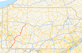
Route information Auxiliary route of US 19 Maintained by PennDOT Length: 133 mi[1] (214 km) Major junctions South end:  US 119 near Point Marion, PA
 US 40 in Uniontown
 Toll PA 43 in Uniontown
 PA 51 in Uniontown
 PA 31 near Mt. Pleasant


 I-70 / I-76 / Penna. Tpk. in New Stanton
 US 30 in Greensburg
 US 22 near Delmont
US 22 near Blairsville

 US 422 / PA 56 near Indiana
 US 322 near DuBois
North end:  US 219 in Sandy Township
Highway system United States Numbered Highways
List • Bannered • Divided • ReplacedRoads in Pennsylvania
Interstate • US • State • Legislative←  PA 118
PA 120  →
→U.S. Route 119 travels through Connellsville, Greensburg, and Punxsutawney, and bypasses Uniontown and Indiana. There are numerous other boroughs and villages along its 133-mile (214 km) route in the Keystone State. The southern entrance of US 119 is at the West Virginia state line one-half mile south of Point Marion. The northern terminus is at US 219 two miles (3 km) south of DuBois, Pennsylvania. US 119 is in the National Highway System from the West Virginia state line to Exit 0 of PA Turnpike 66, and from US 22 to US 219. From US 22 to US 219, the highway carries the name of the Buffalo-Pittsburgh Highway; from US 22 to PA 56, it is also known as the Patrick J. Stapleton Highway; near Uniontown, it bears the name George C. Marshall Parkway.
Concurrencies along the route include PA 43 from Chadville to US 40; US 40 from the Hopwood interchange to Main Street, Uniontown; Truck PA 711 from Connellsville to North Connellsville; PA 819 from the borough of South Greensburg to the City of Greensburg; Business PA 66 from US 30 in South Greensburg to Greensburg; PA 130 in Greensburg; US 22 from Shieldsburg to two miles (3 km) east of Blairsville; PA 56 from Homer City to US 422; Business US 422 from the Wayne Avenue interchange to the US 422 interchange; Truck PA 286 from US 422 to PA 286; and PA 36 in Punxsutawney.[1][2]
Contents
Route description
Fayette County
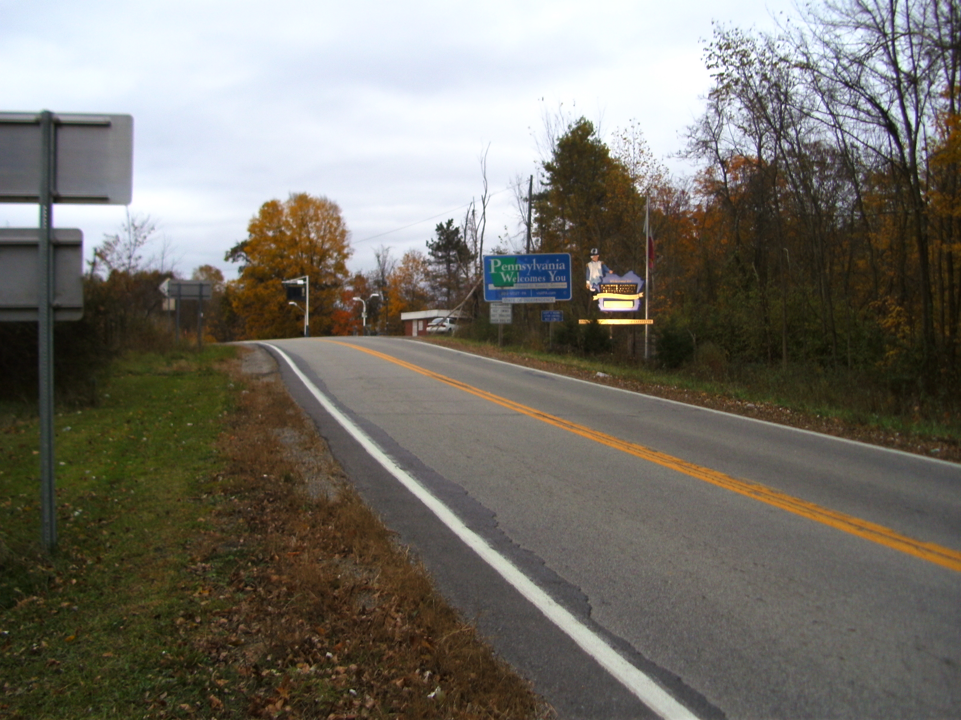
US 119 enters Pennsylvania from Monongalia County, WV just south of Point Marion, PA. Known as Morgantown Rd. for most of its route south of Uniontown, it travels north through Point Marion. The highway leaves the borough upon crossing the Cheat River at its confluence with the Monongahela River. Route 119 then turns toward the east-northeast and heads toward Smithfield. To the northeast of Smithfield, Morgantown Rd. intersects with Big Six Rd., which provides access to PA 43 at exit 8. This begins a section of the highway that runs parallel to two other highways, PA 43 and PA 857, till their termini at the Uniontown bypass in South Union Township.
 U.S. Route 119 as it enters Pennsylvania just south of Point Marion in Fayette County.
US 119 merges with US 40 to form part of the George C. Marshall Parkway, which bypasses the city of Uniontown to the west and north. Exits along the US 119 section of the bypass include Walnut Hill Rd.; McClellandtown Rd. (PA 21); Main St. (US 40 West and US 40 Bus), the north end of concurrency with US 40; Pittsburgh St. (PA 51); N. Gallatin Ave.; and Connellsville Rd. Shortly after the Connellsville Rd. exit, US 119 passes Penn State Fayette, The Eberly Campus.
Eleven miles northeast of Uniontown and six miles (10 km) north of Penn State, US 119 enters the city of Connellsville. Route 119 becomes a one-way pair of 8th and 9th Sts. in western Connellsville. After intersection PA 201/PA 711 (W. Crawford Ave.), US 119 crosses the Youghiogheny River via the Memorial Bridge, one of two bridges in Connellsville. The highway leaves Connellsville as Memorial Blvd and heads to the north intersecting with the southern terminus of PA 982 (Pleasant Valley Rd.).
North of Pleasant Valley Rd. is a trumpet interchange with Everson Valley Rd. Just north of this intersection, US 119 leaves Fayette County, having spent 38 miles (61 km) in Fayette County.[3]
Westmoreland County
The highway enters Westmoreland County in East Huntingdon Township. US 119 continues north between the boroughs of Scottdale and Mount Pleasant. East of Scottdale, US 119 has an exit with PA 819 signed for the two communities, and then west of Mount Pleasant is an interchange with PA 31, which also provides access to PA 981.
Five and a half miles north of Mount Pleasant, just west of Youngwood, US 119 traffic must exit the expressway at a full cloverleaf interchange with the Pennsylvania Turnpike, I-70 West, and PA 66 North. After leaving the expressway, US 119 enters Youngwood as Hellman St., which becomes the one-way pair of 3rd and 4th Sts.
Shortly after leaving Youngwood, US 119 intersects the Lincoln Highway (US 30), which bypasses Greensburg to the west and south. Route 119 becomes Main St. at this point and travels through downtown Greensburg. At PA 130, Pittsburgh St., US 119 turns to the right and leaves Greensburg as Harvey Ave and heads to the northeast toward the historical Hannastown. Once leaving Greensburg US 119 becomes predominantly a two-lane road again for the first time since joining the Uniontown bypass nearly 40 miles (64 km) south.
After passing Hannastown, US 119 continues to the northeast to merge with the William Penn Highway (US 22 (PA)). The concurrency runs to the east-northeast toward Blairsville where US 119 leaves Westmoreland County after spending 33 miles (53 km) in the county.[4]
Indiana County
US 119 enters Indiana County in the borough of Blairsville after crossing the Conemaugh River. US 119/US 22 bypasses the borough to the north and heads to the end of the concurrency in Burrell Township. US 119 then takes a more northerly path as the Buffalo-Pittsburgh Highway. While the portion of US 119 between Blairsville and Homer City was a two-lane segment until recent years, this portion of the highway is being widened to four lanes.
Seven miles north of the William Penn Highway, US 119 enters Homer City, merges with PA 56. PA 56 leaves US 119 when the highway intersects the Benjamin Franklin Highway (US 422) south of Indiana. US 119 then becomes an eastern bypass of the borough. The only exit on the bypass is the Philadelphia St. exit at PA 286.
Immediately after passing Indiana, the Buffalo-Pittsburgh Highway becomes a two-lane road again north of an interchange with PA 110 and continues to Home. In Home, US 119 is the eastern terminus of PA 85. US 119 the continues north through rural northern Indiana County before leaving the county in North Mahoning Township after travelling 42 miles (68 km) in the county.[5]
Jefferson and Clearfield Counties
US 119 enters Jefferson County in Young Township. Just north of the Jefferson County border, the Buffalo-Pittsburgh Highway intersects PA 436. After entering Punxsutawney, the home of Punxsutawney Phil, the route merges with PA 36 at Mahoning St. US 119 is concurrent with PA 36 for four blocks before making a left turn on Hampton Ave. Route 119 leaves Punxsutawney shortly thereafter as Ridge Ave. and heads east toward Big Run. Before reaching Big Run, US 119 passes the Punxsutawney Municipal Airport in Bell Township. After passing through Big Run as Main St., the Buffalo-Pittsburgh Highway turns to the north-northeast toward Sykesville, PA.
Shortly after leaving Sykesville, US 119 leaves Jefferson County and enters Clearfield in Sandy Township south of DuBois. After an intersection with US 322, route 119 ends at US 219 just south of DuBois.
US 119 spends 18 miles (29 km) in Jefferson County and less than 3 miles (4.8 km) in Clearfield County.[6]
History
U.S. Route 119 was originally signed in 1926. Until 1927 it ran from West Virginia to New York. Originally, instead of ending a US 219 in Sandy Township, it followed US 219's current alignment for 44 miles (71 km) north to Wilcox. It then followed the present-day PA 321 to Kane where it ran concurrent to US 6 to Smethport, 26 miles (42 km) to the northeast. In Smethport, US 119 travelled the current alignment of PA 46 to Bradford where it turned north to New York via US 219's current alignment. In 1927, US 119 terminated at its current location south of DuBois.
In the 1940s and 1950s, the highway was widened in several places, the most notable include: a 1940 widening from New Stanton to Greensburg; a 1948 widening in Connellsville; a 1956 widening in Uniontown. In 1965, an expressway was completed from PA 819 to PA 31, and in 1966, it was completed from Pennsville to PA 819. This expressway runs between Mount Pleasant and Scottdale.
In 1972, the Uniontown (started in 1971) and Indiana (started in 1969) bypasses were completed. In 1978 an expressway from PA 31 to the PA 66 interchange was completed, which finished the current 11-mile (18 km) expressway from Pennsville to the Pennsylvania Turnpike. In 1993 an expressway from the southern end of the Uniontown bypass to Big Six Road in Georges Township was built parallel to US 119. This is currently part of PA 43 but is the only free section of the Mon-Fayette Expressway. In 2000, US 119 was widened along its concurrency with US 22 in Westmoreland County. Many of the latest improvements have been controversial, but improvements continue to be made.[2]
Major intersections
County Location Mile Destinations Notes Fayette Point Marion 0.0 US 119Continuation into West Virginia 2.0  PA 166
Southern terminus of PA 166. Georges Township 11.3  PA 43
PA 43Interchange via Big Six Road. Uniontown 15.2  PA 857
Northern terminus of PA 857. 15.2 PA 4315.4 US 40Southern terminus of concurrency South Union Township 17.4  PA 21
PA 21Uniontown 18.3 US 40Northern terminus of concurrency 19.2 PA 43Stack interchange. 19.2 PA 51Connellsville 30.2  PA 711
30.2  PA 201
Moyer 33.7  PA 982
Westmoreland East Huntingdon Township 38.5  PA 819
Mt. Pleasant 40.7 PA 31New Stanton 46.1  I-70/I-76, PA 66
US 119 provides access to the Pennsylvania Turnpike and I-70 West toward Washington, PA South Greensburg 50.0 PA 819Southern terminus of concurrency Southwest Greensburg 50.9 US 30Greensburg 52.5  PA 130
52.7 PA 819Northern terminus of concurrency New Alexandria 61.4 US 22Southern terminus of concurrency 62.4  PA 981
Derry Township 66.9 PA 982Indiana Blairsville 71.2  PA 217
Burrell Township 73.9 US 22Northern terminus of concurrency Homer City 81.7 PA 56Southern terminus of concurrency White Township 85.1 PA 56/US 422Northern terminus of concurrency with PA 56 88.8  PA 286
via Philadelphia St. Home 97.4  PA 85
PA 85Eastern terminus of PA 85 North Mahoning Township 111.5  PA 210
Northern terminus of PA 210 Jefferson Young Township 113.1  PA 436
Southern terminus of PA 436 Punxsutawney 115.0  PA 36
PA 36Southern terminus of concurrency 115.3 PA 36Northern terminus of concurrency with PA 36 115.8  PA 310
Southern terminus of PA 310 Big Run 123.7  PA 410
Western terminus of PA 410 Clearfield Sandy Township 131.8 US 322132.9 US 2191.000 mi = 1.609 km; 1.000 km = 0.621 mi References
- ^ a b Google, Inc. Google Maps – US 119 in PA Overview (Map). Cartography by Google, Inc. http://maps.google.com/maps?f=d&saddr=US+119+%26+US+219&daddr=40.259879,-79.567623+to:Point+Marion+Rd%2FUS-119&hl=en&geocode=%3B%3BFUIXXgId2qc8-w&mra=ls&via=1&sll=40.514843,-79.399567&sspn=0.73917,1.235962&ie=UTF8&ll=40.415587,-79.123535&spn=1.480518,2.471924&z=9. Retrieved 2008-10-06.
- ^ a b Kitsko, Jeffrey J.. "US 119". Pennsylvania Highways. http://www.pahighways.com/us/US119.html. Retrieved 2008-10-17.
- ^ Google, Inc. Google Maps – US 119 in Fayette County (Map). Cartography by Google, Inc. http://maps.google.com/maps?f=d&saddr=Morgantown+Rd%2FUS-119&daddr=40.112739,-79.555779&hl=en&geocode=FUIXXgId2qc8-w%3B&mra=dme&mrcr=0&mrsp=1&sz=13&sll=40.084639,-79.542046&sspn=0.099422,0.153809&ie=UTF8&ll=39.965543,-79.749756&spn=0.796759,1.230469&z=10. Retrieved 2008-10-17.
- ^ Google, Inc. Google Maps – US 119 in Westmoreland County (Map). Cartography by Google, Inc. http://maps.google.com/maps?f=d&saddr=US-119%2FUS-22&daddr=US-119+to:US-119+to:40.112509,-79.55477&hl=en&geocode=FTwIaQId_GdG-w%3BFXl_ZwIdxsxC-w%3BFS5QZgIdSuJB-w%3B&mra=dme&mrcr=0&mrsp=3&sz=16&via=1,2&sll=40.109572,-79.549899&sspn=0.012423,0.019226&ie=UTF8&ll=40.301523,-79.409866&spn=0.396417,0.615234&z=11. Retrieved 2008-10-17.
- ^ Google, Inc. Google Maps – US 119 in Indiana County (Map). Cartography by Google, Inc. http://maps.google.com/maps?f=d&saddr=40.437933,-79.272194&daddr=Route+119%2FUS-119&hl=en&geocode=%3BFUg6cAIdj4VK-w&mra=dme&mrcr=0&mrsp=0&sz=14&sll=40.427153,-79.25786&sspn=0.04946,0.076904&ie=UTF8&ll=40.710833,-79.153748&spn=0.788006,1.230469&z=10. Retrieved 2008-10-17.
- ^ Google, Inc. Google Maps – US 119 in Jefferson and Clearfield Counties (Map). Cartography by Google, Inc. http://maps.google.com/maps?f=d&saddr=Blinker+Pkwy%2FUS-119&daddr=40.909426,-79.002278&hl=en&geocode=FUwCcwIdogVO-w%3B&mra=dme&mrcr=0&mrsp=1&sz=16&sll=40.90954,-79.000347&sspn=0.012276,0.019226&ie=UTF8&ll=41.002703,-78.884583&spn=0.392273,0.615234&z=11. Retrieved 2008-10-17.
Categories:- U.S. Highways in Pennsylvania
- U.S. Route 19


Wikimedia Foundation. 2010.