- U.S. Route 219
-
U.S. Route 219

Route information Auxiliary route of US 19 Length: 535 mi (861 km) Major junctions South end:  US 460 in Rich Creek, VA
 I-64 in Lewisburg, WV
 US 33 in Elkins, WV
 US 50 in Garrett County, MD

 I-68 / US 40 in Garrett County, MD


 I-70 / I-76 / Penna. Tpk. in Somerset, PA
 US 30 near Jennerstown, PA
 PA 56 in Johnstown, PA
 US 22 near Ebensburg, PA
 I-80 in Falls Creek, PA

 I-86 / NY 17 near Salamanca, NY
North end: 
 I-90 / Thruway in W. Seneca, NY
Highway system United States Numbered Highways
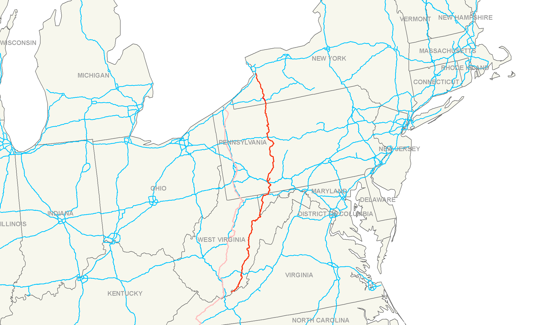
List • Bannered • Divided • ReplacedU.S. Route 219 is a spur of U.S. Route 19. It runs for 535 miles (861 km) from West Seneca, New York at an interchange with Interstate 90, to Rich Creek, Virginia, intersecting at U.S. Route 460. U.S. 219 is found (from north to south) in New York, Pennsylvania, Maryland, West Virginia, and Virginia. Much of the Route in West Virginia follows the old Indian warpath known as the Seneca Trail (Great Indian Warpath).
In February 2009 it was reported that a group known as the 219 Association [1] was pursuing the goal of urging several states to transform Route 219 into a 1,500-mile-long divided highway which the group hoped would be referred to as Continental 1. It has been proposed that U.S. 219 could spur trade between Canada, the U.S., and the Caribbean region.[2]
Contents
Route description
Virginia
U.S. Route 219 starts in Rich Creek at U.S. Route 460, and heads northeast to the West Virginia state line. Until the early 1980s, US 219 continued southwest with US 460 from Rich Creek, re-entering West Virginia to end at US 19 in Bluefield. It now only runs 1.3 miles (2.1 km) in Virginia.
US 219 was initially added to the state highway system in the early 1920s as State Route 231. It became State Route 216 in the 1928 renumbering and State Route 124 in the 1933 renumbering, finally becoming part of the extended US 219 (along with State Route 8, now U.S. Route 460, west of Rich Creek) in the late 1930s.
West Virginia
US 219 enters West Virginia in Peterstown at the split of US 219 and WV 12. US 219 then heads northeast into Union. US 219 continues through Greenbrier County running through the towns of Ronceverte, Lewisburg, where it intersects US 60, and Falling Spring. US 219 continues north into Pocahontas County and through the towns of Hillsboro and Marlinton. US 219 runs north into Randolph County and begins its dual certification with US 250. They both serve the towns of Huttonsville, Mill Creek, and Beverly, where US 250 splits from US 219 at their intersection with US 33. Route 219 continues through the towns of Elkins and Montrose until it enters Tucker County. From here, US 219 runs through the towns of Parsons and Thomas. US 219 heads north into rural Preston County and exits West Virginia into Garrett County, Maryland.
Maryland
Main article: U.S. Route 219 in MarylandUS 219 enters Maryland near Backbone Mountain on the West Virginia border, crosses US 50 and enters the town of Oakland. It crosses Maryland Route 135 and Maryland Route 39 in Oakland, before passing Deep Creek Lake. After traveling through Accident it intersects Interstate 68 east of Friendsville, providing access to Morgantown, West Virginia, Frostburg and Cumberland. US 219 runs concurrently with I-68 at Exit 14A and exits I-68 at Exit 22. US 219 crosses the Mason-Dixon Line, the Pennsylvania border, south of Salisbury, Pennsylvania.
Pennsylvania
Main article: U.S. Route 219 in Pennsylvania
From near Grantsville, Maryland north to Ebensburg, Pennsylvania, US 219 is Corridor N of the Appalachian Development Highway System. From Somerset, Pennsylvania to just south of Carrolltown, Pennsylvania, US 219 is a limited-access highway. On August 9, 2007, Pennsylvania State Transportation Secretary Allen D. Biehler unveiled four signs along US Route 219 that dedicated the route from Maryland to Cambria County, Pennsylvania as the "Flight 93 Memorial Highway".[3] From Carrolltown US 219 runs largely as a two-lane road to DuBois, Pennsylvania, through which it runs as Brady Street, and then returns to a two-lane road after a junction with Interstate 80. US 219 runs directly through the towns of Brockway, Ridgway, and Johnsonburg before reaching Wilcox, where PA Route 321 splits and heads for the borough of Kane. US 219 continues north as a two-lane road until reaching Bradford, where it becomes a limited-access highway and remains so until reaching the New York border.
New York
Main article: U.S. Route 219 in New YorkUS 219 enters Western New York from Pennsylvania south of the Village of Limestone in the Town of Carrollton in Cattaraugus County. Proceeding northward, the highway splits into the main route and a "business route" that follows the original main route. The main route merges with Interstate 86/New York State Route 17 at Exit 23 north of Limestone and splits from I-86 at Exit 21 in the city of Salamanca. The business route crosses the Allegheny River and the Southern Tier Expressway and joins New York State Route 417 to the City of Salamanca. Separating from NY 417, the business route rejoins with the main US 219 and turns northward through the rest of Cattaraugus County, passing through Peth, Great Valley, Ellicottville, and Ashford Hollow before crossing the Cattaraugus Creek and entering Erie County. About 4 miles south of Springville, New York, US 219 becomes a divided, limited-access highway. As such, it continues north through half of the county, terminating at exit 55 of the New York State Thruway (Interstate 90) near the west town line of West Seneca south of the City of Buffalo. Before joining the Thruway, US 219 runs parallel to it for about one mile (1.6 km). The interchange is set up as such that drivers can exit and re-enter the Thruway via US 219 without leaving the expressway.
Continental 1
The Pennsylvania 219 Association was founded in the late 1960s by a group of volunteers with the shared dream of seeing US Route 219 upgraded to a four-lane highway. Members of the Association were spread along the 219 corridor from Bradford in the north to Somerset County in the south. It was a loosely formed and governed group which enjoyed only moderate success over its 30 years of existence.[4]
In the 1990s, the PA 219 Association recognized that if it were going to become more effective, it had to create a more professional organization. The Association became the genesis of the Continental One Alliance which also included representatives from Maryland, West Virginia, and Erie County, New York. The Pennsylvania 219 Association was absorbed into the C-1 Alliance and ceased to exist as a separate organization.
In November 1998, in DuBois, Pennsylvania, the Alliance conducted a day-long strategic planning meeting. Approximately 80 people participated in the planning process, with representatives from Maryland, West Virginia, and New York and all along the Pennsylvania 219 corridor from Bradford in the north to Somerset County in the south. A second planning meeting was held the following month at Holiday Valley Resort in Ellicottville, New York, and included representatives from the four founding states and Canada.
The attendees recognized that federal highway funding had become increasingly competitive and that 219 was competing for funding with other trade and travel corridors throughout the United States; and competing with other transportation priorities within the individual states. Other trade and travel corridors were well financed with professional staff and were able to lobby extensively in Washington and their state capitals.
As a result, the group decided to formally organize a multi-state coalition of public and private partners to push for the construction of a four-lane limited access highway from Toronto, Canada, to Miami, Florida. Four key goals were established:
- Secure designation of Continental 1 as a federally recognized trade and travel corridor.
- Secure funding for the construction of C-1 (Route 219) from Springville, New York, to its point of intersection with Interstate 86 at Salamanca, New York.
- Secure funding for preliminary engineering and environmental studies for that part of Continental 1 (Route 219) from Bradford, PA, to its intersection with Interstate 80 at DuBois, PA.
- Build an organization with long term sustainability.
To accomplish these goals, the Continental 1 Board began an intensive fund raising campaign and over the next year secured approximately $400,000, primarily from the private sector. It also received financial and political support from Chambers of Commerce and counties along the corridor. Continental 1 was formally incorporated on July 5, 2000. In the fall of 2000, Continental 1 hired an Executive Director and engaged the services of a Washington-based lobbyist.
Over the next several years, the Executive Director, lobbyist, and the volunteer board worked in Washington, Albany, and Harrisburg to secure two federal grants. The first grant provided $1.5 million to conduct a comprehensive study of the proposed corridor and was administered by the Pennsylvania Department of Transportation. This study was completed in the summer of 2007.
The second grant, a $1.5 million federal DOT grant, is being administered by the New York Department of Transportation and is directed to increase public awareness of Continental 1 and to establish a stable base for Continental 1's continued operations. A second objective of the study is to conduct a comprehensive study of trade and travel corridors. The study was kicked off during the late spring of 2008.
See also
References
- U.S. 219 Freeway Extension (NY)
- Appalachian Regional Commission (September 30, 2004). "ARC|ADHS Approved Corridors and Termini". Retrieved 28 July 2005.
- ^ 219 Association
- ^ "On the road to Continental One". Business First of Buffalo, (By James Fink). 2009-02-10. http://www.bizjournals.com/buffalo/stories/2009/02/09/daily18.html. "The region would benefit from its strategic location as a border city to Canada and also as the closest American metropolitan area to the lucrative Toronto market. Continental One is a 1,500-mile-long (2,400 km) stretch of highway that would run from Toronto south to Miami. It would serve as link between the Caribbean and Canada. Part of it will be new, other parts an upgrade of existing routes. A new highway (the Mid-Peninsula Highway) will be built between Toronto and Buffalo, New York. The proposed twin of the Peace Bridge across the Niagara River is also tied into the plans."
- ^ Pennsylvania State Department of Transportation website - ROUTE 219 NAMED IN HONOR OF FLIGHT 93 HEROES
- ^ http://www.continental1.org/
External links
- Continental 1 Trade & Travel Corridor
- Stimulus resurrects idea of Continental One, Friday, March 20, 2009
Browse numbered routes ←  SR 218
VA US 220  →
→←  WV 218
list US 220 →none Spurs of SR 23
1923-1928SR 232 > < SR 215 District 2 State Routes
1928–1933SR 217 > Metro Area Johnstown · Westmont · Brownstown · Richland Township · East Conemaugh · Ferndale · Franklin · DaisytownHistory/Attractions Johnstown Flood · Johnstown Flood National Memorial · South Fork Dam · Allegheny Portage Railroad · Cambria Iron Company · Inclined Plane · Grandview Cemetery · Staple Bend Tunnel · Stone Bridge · Conemaugh RiverTransportation Education Industry Entertainment/Sports Pasquerilla Performing Arts Center · Johnstown Symphony Orchestra · Johnstown Blue Birds · Johnstown Jets · Johnstown Chiefs · Cambria County War Memorial Arena · Point StadiumMedia/Pop Culture TV/Radio Broadcast television in West-Central Pennsylvania, including Johnstown, Altoona and State College Local stations WPSU (3.1 PBS, 3.2 Create, 3.3 PBS World) - WJAC (6.1 NBC, 6.2 Me-TV) - WWCP (8.1 Fox, 8.2 WATM) - WTAJ (10.1 CBS) - WSCP-CA (13 Ind) - WPCW (19.1 CW) - WATM (23.1 ABC HD, 23.2 WWCP HD, 23.3 This TV) - WHVL-LP (29.1 MNTV, 29.2 A1) - W36BE-D (16.1 ABC, 16.2 Antenna TV) - W41CF (41 Ind) - WKBS (47.1 COR) - WLLS-LP (49 A1)
Local cable
channelsIUP-TV (Ind)
Adjacent locals Pennsylvania Broadcast television: Binghamton, NY • Buffalo, NY • Elmira, NY • Erie • Johnstown/Altoona/State College • New York City • Philadelphia • Pittsburgh • Scranton/Wilkes-Barre • Susquehanna Valley (Harrisburg) • Washington, DC • Youngstown, OH
Radio stations in the Johnstown, Pennsylvania market By FM frequency By AM frequency By callsign ¹ Audio for WJAC-TV Pennsylvania radio markets: Allentown-Bethlehem • Altoona • Bradford-Coudersport • Chambersburg-Waynesboro • Erie • Harrisburg-Lebanon-Carlisle • Lancaster • Montrose • New Castle • Philadelphia • Pittsburgh • Reading • State College • Sunbury-Selinsgrove-Lewisburg • Wilkes Barre-Scranton • Sayre-Towanda-Mansfield-Wellsboro • Williamsport • York
Other Pennsylvania radio regions: Bedford • Indiana • Johnstown • Lewistown-Mifflintown • Meadville-Franklin • Punxsutawney-DuBois • St. Marys-Emporium-Kane • Stroudsburg • Warren
See also: List of radio stations in PennsylvaniaCategories:- Three-digit U.S. Highways
- U.S. Route 19
- U.S. Highways in Virginia
- U.S. Highways in West Virginia
- U.S. Highways in Pennsylvania
- Transportation in Giles County, Virginia
- Transportation in Preston County, West Virginia
- Transportation in Tucker County, West Virginia
- Transportation in Randolph County, West Virginia
- Transportation in Pocahontas County, West Virginia
- Transportation in Greenbrier County, West Virginia
- Transportation in Monroe County, West Virginia
- United Airlines Flight 93


Wikimedia Foundation. 2010.