- Pennsylvania Route 982
-
PA Route 982
Route information Maintained by PennDOT Length: 33 mi[1] (53.11 km) Major junctions South end:  US 119 at Moyer
 PA 31 near Mount Pleasant
 PA 130 near Pleasant Unity
 US 30 near Youngstown
North end:  US 22 / US 119 near Blairsville
Location Counties: Fayette, Westmoreland Highway system Roads in Pennsylvania
Interstate • US • State • Legislative←  PA 981
PA 983  →
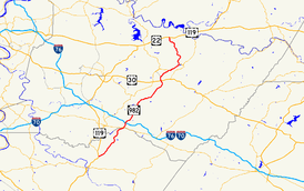
→Pennsylvania Route 982 is a state highway which runs 33 miles[1] across Fayette and Westmoreland counties, in southwestern Pennsylvania. The highway begins at U.S. Route 119 in Moyer, Pennsylvania, and runs northward into Westmoreland County, passing through the towns of Youngstown, Latrobe, and Derry before ending at U.S. Route 22/U.S. Route 119 near Blairsville.
Route description
Pennsylvania Route 982 begins at U.S. Route 119 near Moyer. From there, it runs northeast across rural Fayette and Westmoreland counties, meeting Pennsylvania Route 31 and crossing the Pennsylvania Turnpike without access.[2] The route intersects Pennsylvania Route 130 about two miles (3 km) southeast of Pleasant Unity, Pennsylvania.[3] The route then passes through Youngstown, and then meets U.S. Route 30 at a cloverleaf interchange. The route runs along the eastern end of Latrobe, Pennsylvania and through McChesneytown. Route 982 then ends at U.S. Route 22 and U.S. Route 119 near Blairsville. Before the construction of the Conemaugh Dam, Route 982 used to occupy Livermore Road, across from its current terminus, and continued on, crossing the Conemaugh River at Livermore, Pennsylvania and connecting with PA 217 a few miles north in Indiana County. Remnants of this section, before Newport Road, can still be seen at the Virginia Farms tract, which is owned by the Army Corp. of Engineers for flood control, and leased to the Game Commission for public use. A small parking spot next to the gate provides easy access, and the remaining surface is well intact, running all the way to the Conemaugh River, at the former site of Fillmore, Pa, on the opposite side from Livermore. This area (Virginia Farms), has a rich history dating back to colonial settlement, and along the former surface, foundations as well as a small bridge crossing a creek can still be seen.
Major intersections
County Location Mile Destinations Notes Fayette Bullskin Township 0.0 US 119 (Memorial Boulevard)Westmoreland Mount Pleasant Township PA 31 PA 130Unity Township US 30 (Lincoln Highway)Interchange Derry Township US 22 / US 119 (William Penn Highway)1.000 mi = 1.609 km; 1.000 km = 0.621 mi References
- ^ a b Pennsylvania Highways: Route 982
- ^ Google, Inc. Google Maps – Google Maps image of PA 982 at I-76 (Map). Cartography by Google, Inc. http://maps.google.com/?ie=UTF8&ll=40.158312,-79.478166&spn=0.011037,0.020084&z=16. Retrieved June 8, 2009.
- ^ Google Maps image of PA 982/PA 130 intersection
Categories:- State highways in Pennsylvania
- Transportation in Fayette County, Pennsylvania
- Transportation in Westmoreland County, Pennsylvania


Wikimedia Foundation. 2010.