- Central Province, Sri Lanka
-
Central Province
මධ්යම පළාත
மத்திய மாகாணம்— Province — 
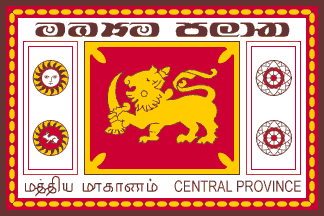
FlagLocation within Sri Lanka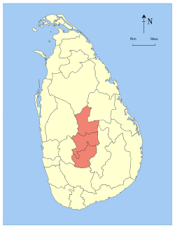
Country  Sri Lanka
Created 1833 Admitted 14 November 1987 Capital Kandy Largest City Kandy Government – Governor Tikiri Kobbekaduwa – Chief Minister Sarath Ekanayake Area – Total 5,674 km2 (2,190.7 sq mi) Area rank 6th (8.63% of total area) Population (2001) – Total 2,423,966 – Rank 2nd (12.97% of total pop.) – Density 427.2/km2 (1,106.5/sq mi) Gross Regional Product (2010)[1] – Total Rs 465 billion – Rank 4th (9.6% of total) Time zone Sri Lanka (UTC+05:30) Official Languages Sinhala, Tamil Website cpcouncil.net The Central Province (Sinhala: මධ්යම පළාත Madhyama Palata, Tamil: மத்திய மாகாணம் Malaiyakam Maakaanam) of Sri Lanka consists primarily of mountainous terrain. Both the hill capital Kandy and the city of Nuwara Eliya are located within the Central Province as well as Sri Pada. The province produces much of the famous Ceylon tea, planted by the British in the 1860s after a devastating disease killed all the coffee plantations in the province. Central Province attracts many tourists, with hill station towns such as Kandy, Gampola, Hatton and Nuwara Eliya.
Contents
History
Though three successive European powers invaded Sri Lanka during the 16th to the 19th century, the Central Province maintained its independence until the early 19th century when the British finally managed to conqueror Kandy.
The historic Matale town, Temple of the Tooth, Dambulla cave temple,Aluwihare temple and the Sigiriya rock is also in the Central Province.
Geography
The province has an area of 5,674 km²,and a population of 2,421,148. Some major towns include Kandy (119 186), Matale (39 869), Dambulla (75 290) , Gampola (26 481) , Nuwara Eliya (27 449) Hatton (16 790).
Climate
The climate is cool, and many areas about 1500 metres often have chilly nights. The western slopes are very wet, some places having almost 7000 mm of rain per year. The eastern slopes are parts of the mid-dry zone as it is receiving rain only from North-Eastern monsoon. The Temperatures range from 24°C at Kandy to just 16°C in Nuwara Eliya, which is located 1,889 m above sea level. The highest mountains in Sri Lanka are located in the Central Province. The terrain is mostly mountainous, with deep valleys cutting into it. The two main mountain regions are the central massif and the Knuckles range to the east of Kandy.
Demographics
The population is a mixture of Sinhalese, Tamil and the Moors. Many tea plantation workers are Indian Tamils, brought over to Sri Lanka by the British in the 19th century.
Ethnicity
Ethnic group Population % Sinhala 1,584,100 65.35% Sri Lankan Tamil 122,438 5.05% Indian Tamil 482,945 19.92% Sri Lankan Moor 223,076 9.20% Burger 3,589 0.15% other 7,818 0.32% Total 2,423,966 100.00% Administrative divisions
Main articles: Districts of Sri Lanka, Divisional Secretariats of Sri Lanka, and List of cities in Sri LankaCentral Province is divided into 3 districts and 36 divisional secretariats.
Districts
Administrative Divisions of Central Province district Capital Area (km²) Population Kandy District Kandy 1,940 1,279,028 Matale District Matale 1,993 441,328 Nuwara Eliya District Nuwara Eliya 1,741 703,610 Divisional Secretariats
Main article: Divisional Secretariats of Central Province, Sri LankaThe districts of the Sri Lanka are divided into administrative sub-units known as divisional secretariats. These were originally based on the feudal counties, the korales and ratas. They were formerly known as 'D.R.O. Divisions' after the 'Divisional Revenue Officer'. Later the D.R.O.s became 'Assistant Government Agents' and the Divisions were known as 'A.G.A. Divisions'. Currently, the Divisions are administered by a 'Divisional Secretary', and are known as a 'D.S. Divisions'.
There are 36 divisional secretariats divided in Central Province, which are listed below, by district. There are 20 in Kandy District, 11 in Matale District and 5 in Nuwara Eliya District.
Cities
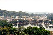 Kandy
Kandy
Largest Metropolitan Areas in Central Province, Sri Lanka Rank City Admin. District Pop. Rank City Admin. District Pop. 1 Kandy Kandy 119,186 7 Nawalapitiya Kandy 14,685 2 Dambulla Matale 75,290 8 Talawakele Nuwara Eliya 3,458 3 Matale Matale 39,869 9 Harispattuwa Kandy 1,690 4 Nuwara Eliya Nuwara Eliya 27,449 10 Kadugannawa Kandy 1,323 5 Gampola Kandy 26,481 11 Sigiriya Matale 1,068 6 Hatton Kandy 16,790 2009 estimate[2] See also
References
Maps
External links

North Western Province North Central Province North Central Province North Western Province
Sabaragamuwa Province
Eastern Province
Uva Province Central Province

Sabaragamuwa Province Sabaragamuwa Province Uva Province Topics on Central Province, Sri Lanka History Timeline of Central Province, Sri Lanka history:
Topics: History of Kandy · History of Matale · History of Nuwara Eliya · Pre-kingdom Kandy · Kingdom of Kandy · Kandyan Treaty of 1638 · Portuguese period in Ceylon · Kandyan Wars · Colonial Kandy · Kandyan Convention · Kandyan Convention · Matale Rebellion · South East Asia CommandGovernment Central Provincial Council · Provincial Governor · Chief Minister · General elections · Electoral districts (Kandy · Matale · Nuwara Eliya)Geography National Parks · Provincial parks · Rivers · Natural HistoryEconomy Agriculture · Transportation (Highways · Railways) · Buildings and Structures · TourismDemographics Demographic history · Religion · Language demographicsCulture Architecture · Art · Cinema · Education · Literature · Music · Sport · Dance · Cuisine · FestivalsSymbols Flag of Central Province · Motto · Coat of armsCommunities Provinces of Sri Lanka Categories:- Central Province, Sri Lanka
- Provinces of Sri Lanka
- Kingdom of Kandy
- Central Province, Sri Lanka geography stubs


Wikimedia Foundation. 2010.