- Maryhill Central railway station
-
Maryhill Central 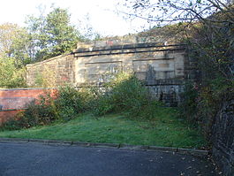
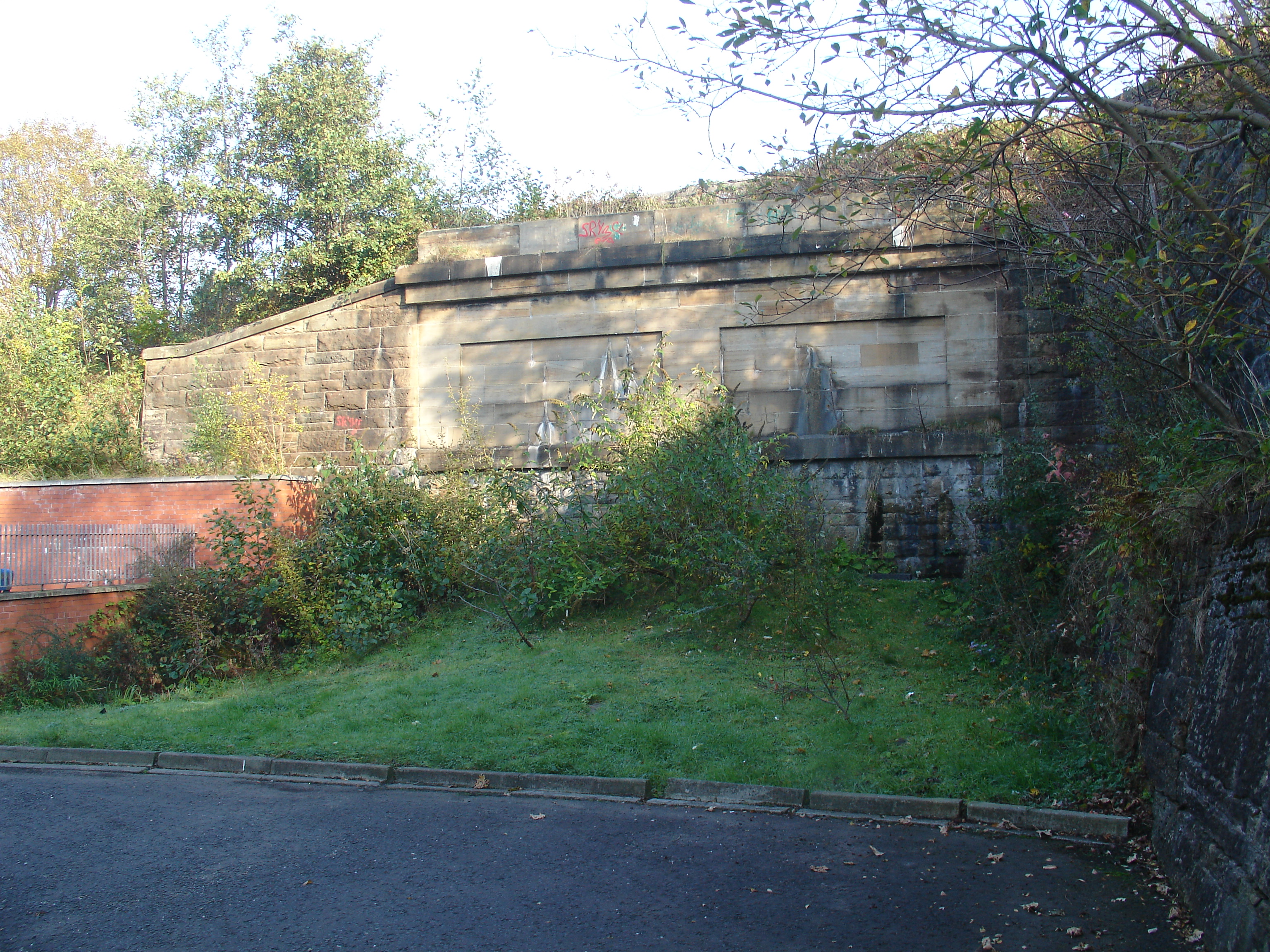
This is all that is visible of the southern portal of the former Lanarkshire and Dunbartonshire Railway line heading north from Maryhill Central station. Hidden behind the Gala Bingo club, the tunnel entrance has been backfilled with earth, and the arch keystone is visible behind the shrubbery. Crossing above is the Glasgow Branch of the Forth & Clyde Canal. Location Place Maryhill Area Glasgow Coordinates 55°53′15″N 4°17′16″W / 55.88752°N 4.28782°WCoordinates: 55°53′15″N 4°17′16″W / 55.88752°N 4.28782°W Operations Original company Glasgow Central Railway
Lanarkshire and Dunbartonshire RailwayPre-grouping Caledonian Railway Post-grouping LMS Platforms 4 History 26 November 1894 Opened as Maryhill Barracks 1 October 1895 Renamed as Maryhill[1] 15 September 1952 Renamed as Maryhill Central[1] 2 November 1959 GCR services ceased 5 October 1964 Closed to passengers[1] Disused railway stations in the United Kingdom Closed railway stations in Britain
A B C D–F G H–J K–L M–O P–R S T–V W–ZMaryhill Central was a railway station to the north west of Glasgow.
Contents
Location
To the west of the station was a triangular set of junctions. Immediately to the west was Maryhill Central junction where the line to Kirklee diverged to the south and the Lanarkshire and Dunbartonshire Railway headed east to Bellshaugh Junction where the western side of the triangle (from Kirklee Junction at the southern point of the junctions) and the Lanarkshire and Dunbartonshire Railway met before the line to Dawsholm diverged to the north. The station served the nearby Maryhill Barracks and it was from this station that tanks and soldiers departed for Buchanan Street station in order to be deployed at George Square in the 'Red Scare' of January 1919.
Closure
It was closed to passengers on 2 November 1959 on the Glasgow Central Railway route and on 5 October 1964 on the Lanarkshire and Dunbartonshire Railway between Possil and Partick, with the lines in the area being closed at the beginning of October 1964.
Current site usage
The site of the station is now occupied by Maryhill Shopping Centre which was built in the early 1980s. A space was left in the basement of the shopping centre to allow the line to be re-opened in future however, this was still considered an option in the mid 1990s with the building of a large bingo hall on the cutting east of site still left a channel for the original line to be re-opened below ground. However this prospect was put to rest in 1999 with the sale of land for housing along many parts of the track in the Kirklee and Cleveden sections of the track, also the demolition of many of the bridges around the same area for safety reasons.
Maryhill Shopping Centre was demolished in early 2010 and replaced by a new Tesco supermarket. The void beneath the supermarket for the railway station has again been retained to allow the future possibility of reopening the railway line.
Railway routes
Preceding station Historical railways Following station Kirklee
Line and station closedCaledonian Railway
Terminus Dawsholm
Line and station closedCaledonian Railway
Kelvinside
Line and station closedCaledonian Railway
Possil
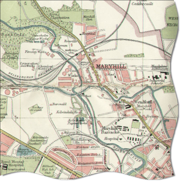
Line and station closed1923 map of Maryhill
 Map of railways in the locality in 1923. Both Maryhill stations are shown, Maryhill Central (also confusingly called 'Maryhill') is adjacent to the barracks
References
Notes
Sources
- Butt, R. V. J. (1995). The Directory of Railway Stations: details every public and private passenger station, halt, platform and stopping place, past and present (1st ed.). Sparkford: Patrick Stephens Ltd. ISBN 1-8526-0508-1. OCLC 60251199.
- Jowett, Alan (March 1989). Jowett's Railway Atlas of Great Britain and Ireland: From Pre-Grouping to the Present Day (1st ed.). Sparkford: Patrick Stephens Ltd. ISBN 1-8526-0086-1. OCLC 22311137.
- Jowett, Alan (2000). Jowett's Nationalised Railway Atlas (1st ed.). Penryn, Cornwall: Atlantic Transport Publishers. ISBN 0-9068-9999-0. OCLC 228266687.
Categories:- Disused railway stations in Glasgow
- Railway stations opened in 1894
- Railway stations closed in 1964
- Beeching closures in Scotland
- Former Caledonian Railway stations
Wikimedia Foundation. 2010.