- Cronulla, New South Wales
-
Cronulla
Sydney, New South Wales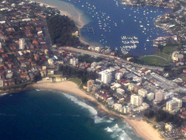
Cronulla, New South WalesPopulation: 16,754 (2006 Census) Established: 1908 Postcode: 2230 Location: 26 km (16 mi) south of Sydney CBD LGA: Sutherland Shire State District: Cronulla Federal Division: Cook Suburbs around Cronulla: Caringbah Kurnell Kurnell Woolooware Cronulla Bate Bay Burraneer Maianbar Bundeena Cronulla is a beachside suburb, in southern Sydney, in the state of New South Wales, Australia. Cronulla is located 26 kilometres south of the Sydney central business district, in the local government area of Sutherland Shire.
Cronulla is located on a peninsula framed by Botany Bay to the north, Bate Bay to the east, Port Hacking to the south, and Gunnamatta Bay to the west. The neighbouring suburb of Woolooware lies to the west of Cronulla, and Burraneer lies to the south-west. The Kurnell peninsula, the site of the first landfall on the eastern coastline made by Lt. (later Captain) James Cook in 1770, is accessed by driving northeast out of Cronulla on Captain Cook Drive.
Contents
History
 Cronulla Theatre and Cronulla Plaza
Cronulla is derived from kurranulla, meaning ‘‘place of the pink seashells’’ in the dialect of the area's Aboriginal inhabitants, the Gweagal, who were a clan of the Tharawal (or Dharawal) tribe of Indigenous Australians. They were the traditional custodians of the southern geographic areas of Sydney. The beaches were named by Surveyor Robert Dixon who surveyed here in 1827-28 and by 1840, the main beach was still known as Karranulla.[1]
Matthew Flinders and George Bass explored and mapped the coastline and Port Hacking estuary in 1796 and the southernmost point of Cronulla is named Bass and Flinders Point, in their honour. John Connell received a grant of 380 acres (1.5 km2) in 1835. Thomas Holt (1811-88) owned most of the land that stretched from Sutherland to Cronulla in the 1860s. Holt built Sutherland House on the foreshore of Gwawley Bay in 1818, on the eastern side of Sylvania. The Cronulla area was subdivided in 1895 and land was offered for sale at 10 pounds per acre. In 1899, the government named the area Gunnamatta, which means sandy hills. On the 26th February 1908 it was officially changed to Cronulla and Gunnamatta was used for the name of the bay, on the western side.
 Northies Hotel
After the Illawarra railway line was built to Sutherland in 1885, the area became popular for picnics and swimming. Steam trams operated between Cronulla and Sutherland from 1911. Many regulars rented beach houses at Cronulla every year for school holidays. The Oriental Hotel was built by Captain Spingall in 1888, on the present site of apartments behind the North Cronulla Hotel. The Cecil Hotel was located on the foreshore of South Cronulla and the Ritz Café was popular with holiday-makers. The Cecil Apartments were built on the former site of this hotel. The steam trams were replaced by the Cronulla branch of the Illawarra railway line when it opened in 1939.[2]
The post office opened in January 1891, known as Cronulla Beach, but closed in 1893. It reopened in 1907 and the name was officially changed to Cronulla in 1929. The first public school opened in 1910. From the 1950s, many of the guest houses began being replaced by high rise flats. Even though it developed as a residential area, Cronulla remained popular with beachgoers and tourists. Several hotels, motels and serviced apartments operate today. The Cronulla Bicentennial Plaza opened in February 1989.
In 2005, the beachfront at Cronulla was the scene of widely-publicised mob disturbances and violent confrontations.[3] These incidents continued over a number of days and also spread to other areas in Sydney.[4] See 2005 Cronulla riots.
Beaches
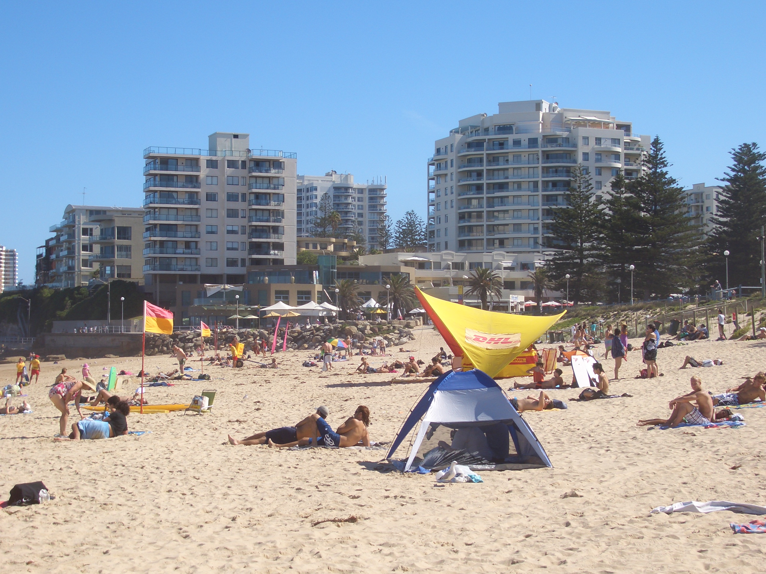
 People on North Cronulla Beach
Cronulla is a popular tourist attraction and attracts many beachgoers from all over Sydney. Cronulla Beach features a long stretch of sand that runs from Boat Harbour to North Cronulla, followed by rock pools and another sandy beach at South Cronulla. The beaches of Cronulla from north to south are: Boat Harbour, Wanda Beach, Elouera Beach, North Cronulla Beach, Cronulla Beach, Blackwoods Beach, Shelly Beach and Oak Park. Local names also apply to various parts of the beach, such as The Alley, between Cronulla Beach and North Cronulla, The Wall, between North Cronulla and Elouera and Green Hills, to the north of Wanda, Sandshoes, near the mouth of the Port Hacking estuary, Voodoo Reef and The Point. The beaches are perfect recreational areas for swimming, surfing, bodyboarding, bodysurfing and other water sports.
Shark Island, just off Cronulla Beach, is a famous surfing and bodyboarding spot, and the site of the annual Shark Island Challenge bodyboarding contest. Gunnamatta Bay provides protected swimming at the baths off Gunnamatta Park. Port Hacking is a popular location for such water sports as waterskiing and wakeboarding.
Parks
 Dunningham Park, North Cronulla
- Bass & Flinders Point is the southernmost part of Cronulla and features a monument to explorers George Bass and Matthew Flinders, who explored the Port Hacking estuary.
- Darook Park, Gunnamatta Park and Tonkin Park are all located on Gunnamatta Bay.
- Cronulla Park is located behind the beach at South Cronulla.
- Dunningham Park sits behind the beach at North Cronulla, shaded by large Norfolk Island Pines. It features a children's playground, picnic tables and a kiosk.
- Monro Park, featuring the Cronulla War Memorial, is located opposite Cronulla railway station.
- Cronulla Recreational Reserve is located beside the car park at Wanda Beach, popular for sport and recreational activities such as flying kites.
- Shelly Park sits behind Shelley Beach.
Commercial area
The main shopping strip runs along Cronulla Street, which has been partly converted into a pedestrian mall known as Cronulla Plaza. It also extends along the Kingsway, Gerrale Street and other surrounding streets. Cronulla has developed a café culture, with some cafés and restaurants located along the North Cronulla foreshore and Cronulla Plaza. Tourists can choose from a number of hotels, motels and serviced apartments. Cronulla has many attractions including an independent cinema, nightclubs, pubs and bars. Northies is a well-known pub, near North Cronulla Beach.
Transport
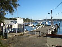 Cronulla Ferry Wharf
Trains terminate at Cronulla railway station on the Cronulla branch of the Illawarra line, on the City Rail network. Cronulla Tunnel Gallery is just north of the station, linking Cronulla Street to Tonkin Street.
Cronulla and National Park Ferry Cruises runs passenger services around Port Hacking and a regular route between Cronulla and Bundeena, on the edge of the Royal National Park. The Cronulla Ferry wharf sits on Gunnamatta Bay, beside Tonkin Park.
Veolia Transport NSW has several bus routes that stop at Cronulla Railway Station. These are the 969 Sutherland via Miranda and North Caringbah, 962 Bankstown via Sutherland and Illawong, 971 to Hursville via Sylvania, 988 to Miranda via Wooloware and 987 Kurnell via North Cronulla.
Sport
 Cronulla Beach and rock pool
- The local National Rugby League football club is the Cronulla-Sutherland Sharks. The Cronulla-Sutherland League's Club and home ground, Endeavour Field, are located on Captain Cook Drive at Woolooware.
- Surf lifesaving clubs are located along the beach at Wanda, Elouera, North Cronulla and South Cronulla.
- Many soccer clubs are located in the Cronulla district, the most prominent being Cronulla Seagulls and the Cronulla RSL clubs.
- Surfing plays a major role in Cronulla. Famous professional surfer and 1999 world champion Mark Occhilupo ('Occy') grew up surfing in Cronulla. Many surfboard shapers hand craft their surfboards in Cronulla and the Sutherland Shire.
- The "Cronulla International Cycling Grand Prix" has been held in Cronulla since 2006. In 2009 it was also the Australian National Criterium Championships.[5][6]
Events
- Cronulla Spring Festival is held every year on the second weekend of September. It includes free entertainment, food and many variety stalls.
- Opera On the Beach is an event commonly held at Cronulla as part of the nation's Australia Day celebrations.[7]
Popular culture
- Puberty Blues is a book and movie about the surfing culture in the Sutherland Shire.
- An episode of the popular science-fiction TV series Farscape was filmed in Cronulla.
- The Australia's Next Top Model (Cycle 4) house was situated on Gunnamatta Bay.
Population
Demographics
According to the 2006 Australian Bureau of Statistics Census of Population, there were 16,502 people usually resident in Cronulla. 15.6% stated they were born overseas with the top countries of birth being United Kingdom 4.7%, New Zealand 2.2% and South Africa 0.5%. English was stated as the only language spoken at home by 83.1% of residents and the most common other languages spoken were Greek 1.0%, Italian 0.8% and Spanish 0.6%. The most common responses for religious affiliation were Catholic 29.3%, Anglican 25.3% and Uniting Church 4.1%.[8]
Socioeconomics
The Australian Bureau of statistics found that 23.5% of residents were employed in professional positions, 41% were employed in technical and trade or administrative positions. The average individual income was $687, and mean family income was $1,698 according to the 2006 Australian Census. Unemployment amongst people under 29 is above the state average in 2006 ABS Census data.
Notable residents
- Luke Baines, actor, singer and model.
- Nathan Beves, model, runner-up of the fourth season of The Mole.
- Lara Bingle, model, former partner of cricketer Michael Clarke.
- Matt Corby, runner-up of Australian Idol 2007.
- Brendan Cowell, actor, appeared on Love My Way.
- Daniel MacPherson, Australian actor, TV presenter, notable for being in City Homicide.
- Chris McCormack, ironman, triathlete.
- Toni Pearen, TV presenter, actress.
- Myles Pollard, actor, appeared on McLeod's Daughters.
- Ricky Ponting, former captain of the Australian national cricket team.
- Jason Stevens, former Cronulla-Sutherland Sharks player.
- Cheyenne Tozzi and her model/actress sister Tahyna Tozzi.
- Sharni Vinson, actress, appeared on Home and Away.
Schools
Cronulla is home to a number of primary and secondary schools: Cronulla High School, De La Salle College, Our Lady of Mercy College, Cronulla Public School, South Cronulla Public School, St Francis De Sales, Burraneer Bay Public School, St Aloysius Catholic Primary School.
Churches
St Andrews Anglican Church, St Aloysius Catholic Church, Cronulla Baptist Church, Cronulla Uniting Church, Presbyterian War Memorial Church.
See also
- Electoral district of Cronulla, a seat in the New South Wales Legislative Assembly
- Cronulla railway station
- 2005 Cronulla riots
- Wanda Sand dunes
References
- ^ http://www.sutherland.nsw.gov.au/ssc/rwpattach.nsf/0/Factsheet_6_FINAL_20030728.pdf/$file/Factsheet_6_FINAL_20030728.pdf Sutherland Shire Place Names
- ^ The Book of Sydney Suburbs, Compiled by Frances Pollon, Angus & Robertson Publishers, 1990, Published in Australia ISBN 0-207-14495-8
- ^ "Mob violence envelops Cronulla". AAP. 2005-12-11. http://www.smh.com.au/news/national/mob-violence-envelops-cronulla/2005/12/11/1134235936223.html. Retrieved 2006-08-31.
- ^ "Now churches are targeted". The Australian. unknown. Archived from the original on 2006-06-16. http://web.archive.org/web/20060616130714/http://www.theaustralian.news.com.au/common/story_page/0,5744,17572776%5e601,00.html. Retrieved 2006-08-31.
- ^ National Championships awarded to Cronulla Grand Prix Cycling NSW, Retrieved 13 December 2009
- ^ Daniel Lane McEwen leads pack of cycling aces in race to rebuild shire's reputation Sydney Morning Herald, 26 November 2006, Retrieved 13 December 2009
- ^ Sutherland Shire Council,[1] Australia Day at Cronulla, January, 2011
- ^ http://id.com.au/dosydney/default.aspx?pg=1&gid=1710
 Media related to Cronulla, New South Wales at Wikimedia Commons Coordinates: 34°03′27″S 151°09′08″E / 34.05744°S 151.15219°E
Suburbs and localities within the Sutherland Shire · Southern Sydney · Sydney Suburbs Alfords Point · Bangor · Barden Ridge · Bundeena · Bonnet Bay · Burraneer · Caringbah · Caringbah South · Como · Cronulla · Dolans Bay · Engadine · Grays Point · Gymea · Gymea Bay · Heathcote · Illawong · Jannali · Kangaroo Point · Kareela · Kirrawee · Kurnell · Lilli Pilli · Loftus · Lucas Heights · Maianbar · Menai · Miranda · Oyster Bay · Port Hacking · Sandy Point · Sutherland · Sylvania · Sylvania Waters · Taren Point · Waterfall · Woolooware · Woronora · Woronora Heights · Yarrawarrah · Yowie BayLocalities List of Sydney suburbs Beaches of the Cronulla region Boat Harbour · Wanda Beach · Elouera Beach · North Cronulla Beach · Cronulla Beach · Blackwoods Beach · Shelly Beach · Oak ParkCategories:- Suburbs of Sydney
- Australian Aboriginal placenames
- Botany Bay
- Beaches of New South Wales
- Surfing locations in New South Wales


Wikimedia Foundation. 2010.