Nagybánhegyes

Nagybánhegyes
Nagybánhegyes
Country  Hungary
County Békés
Area
 – Total 42.26 km2 (16.3 sq mi)
Population (2002)
 – Total 1,503
 – Density 36/km2 (93.2/sq mi)
Time zone CET (UTC+1)
 – Summer (DST) CEST (UTC+2)
Postal code 5668
Area code(s) 68
Location of Békés County in Hungary

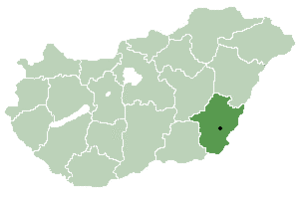
Nagybánhegyes (Slovak: Slovenský Bánhedeš, Hungarian: Nagy Bán-Hegyes means "Smaller Bánhegyes, Smaller Bán-Hill") is a village in Békés County, in the Southern Great Plain region of south-east Hungary.

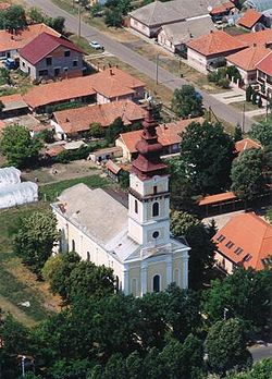
Aerialphotography of Nagybánhegyes

Geography

It covers an area of 42.26 km² and has a population of 1503 people (2002).

Other information

Nagybánhegyes is also the place when the masss-production of the Hungarian product, Pöttyös Túri Rudi was started in 1981.

See also

Coordinates: 46°28′N 20°54′E / 46.467°N 20.9°E / 46.467; 20.9


Wikimedia Foundation. 2010.

Игры ⚽ Поможем сделать НИР

Look at other dictionaries:

  • Nagybánhegyes — Administration …   Wikipédia en Français

  • Orosháza — Aerial view …   Wikipedia

  • Békés County — For the historical county see Békés (former county)Infobox Hungarian county name =Békés region =Southern Great Plain seat = Békéscsaba area = 5631 population = 376,657 density = 69.6 cities = 75Békés County ( hu. Békés megye), is an… …   Wikipedia

  • Dévaványa — Coat of arms …   Wikipedia

  • Mezőberény — Coat of arms …   Wikipedia

  • List of cities, towns, and villages in Békés county — A list of cities and towns, and villages in Békés county in south east Hungary:Largest cities and towns(ordered by population, according to the 2001 census)*Gyula (32 967) *Orosháza (32 052) *Békés (21 657) *Szarvas (18 563) *Gyomaendrőd (15 523) …   Wikipedia

  • Csorvás — Coat of arms …   Wikipedia

  • Mezőhegyes — Coat of arms …   Wikipedia

  • Mezőkovácsháza — Aerial view …   Wikipedia

  • Magyardombegyház — Country  Hungary County Békés Area  – Total 7.64 km2 (2.9 sq&# …   Wikipedia

Share the article and excerpts

Direct link
Do a right-click on the link above
and select “Copy Link”