- New York State Route 990L
-
NYS Route 990L
Route information Maintained by NYSDOT Length: 1.43 mi[1] (2.30 km) Major junctions West end:  NY 12 in Norwich city
East end:  NY 23 in Norwich town
Location Counties: Chenango Highway system Numbered highways in New York
Interstate • U.S. • N.Y. (former) • Reference • County←  I-990
I-990NY 990V  →
→New York State Route 990L (NY 990L) is a reference route in Chenango County, New York, United States. The western terminus of the route is at an intersection with NY 12 in the city of Norwich. Its eastern terminus is at a junction with NY 23 in the town of Norwich. NY 990L is one of four reference routes in New York that has been erroneously signed as a touring route. The highway is known as East Main Street in the city of Norwich and as East River Road in the town of Norwich.
Contents
Route description
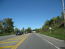 NY 990L and one of its two mis-signed shields along the alignment
NY 990L begins at an intersection with NY 12 (Broad Street) and West Main Street (former NY 319) in the downtown district of the city of Norwich. The route heads east along East Main Street, passing through the eastern portion of the city. NY 990L exits the city and enters the surrounding town of Norwich upon crossing the Chenango River. On the eastern riverbank, NY 990L intersects the lengthy County Route 32 (East River Road). The CR 32 designation ends here, giving way to the state-maintained NY 990L as the latter turns north onto East River Road.[2][3]
The River Road portion of NY 990L is initially less developed as it passes by riverside homes to the west and forested mountains to the east. Near a junction known as Hawley Corners, the amount of development along the highway increases as NY 990L passes by warehouses and small commercial establishments. At Hawley Corners itself, NY 990L ends at NY 23 and East River Road becomes CR 32 once more.[2][3] Typically, reference routes are not signed; however, NY 990L is one of four such routes in New York that is at least partially signed. The East River Road stretch of NY 990L is the only section of the route that is signed; no other signs exist, including on NY 12 and NY 23 as reassurance markers.[4]
Major intersections
The entire route is in Chenango County.
Location Mile[1] Destinations Notes City of Norwich 0.00 NY 12 (South Broad Street)Town of Norwich 0.89  CR 32 (East River Road)
1.43 NY 23 / CR 32East River Road continues north as CR 32 1.000 mi = 1.609 km; 1.000 km = 0.621 mi References
- ^ a b "2008 Traffic Data Report for New York State" (PDF). New York State Department of Transportation. June 16, 2009. p. 371. https://www.nysdot.gov/divisions/engineering/technical-services/hds-respository/NYSDOT_Traffic_Data_Report_2008.pdf. Retrieved January 10, 2010.
- ^ a b Google, Inc. Google Maps – overview map of NY 990L (Map). Cartography by Google, Inc. http://maps.google.com/maps?ie=UTF8&q=from:+E+Main+St+%4042.531164,+-75.523672+to:+CR-32+%4042.539717,+-75.508885&um=1&sa=N&tab=wl. Retrieved July 3, 2009.
- ^ a b New York State Department of Transportation (1978). Norwich Digital Raster Quadrangle (Map). 1:24,000. http://www.nysgis.state.ny.us/gisdata/quads/drg24/dotpreview/index.cfm?code=t34. Retrieved July 3, 2009.
- ^ Sinsabaugh, Mark. "New York State Route 990L". New York Routes. http://www.gribblenation.net/nyroutes/jct/990l.htm. Retrieved July 3, 2009.
External links
Categories:- Reference routes in New York
- Transportation in Chenango County, New York


Wikimedia Foundation. 2010.