- Denny, Falkirk
-
Coordinates: 56°01′05″N 3°54′25″W / 56.018°N 3.907°W
Denny Scottish Gaelic: Deanaidh 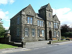
Denny Town House, the former town hall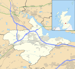
 Denny
Denny
Denny shown within the Falkirk council areaArea 1.03 sq mi (2.7 km2) Population 10,000 [1](2008 est.) - Density 9,709 /sq mi (3,749 /km2) OS grid reference NS806818 - Edinburgh 28.5 mi (45.9 km) - London 348 mi (560 km) Parish Denny Council area Falkirk Lieutenancy area Stirling and Falkirk Country Scotland Sovereign state United Kingdom Post town DENNY Postcode district FK6 Dialling code 01324 Police Central Scotland Fire Central Scotland Ambulance Scottish EU Parliament Scotland UK Parliament Falkirk Scottish Parliament Central Scotland Falkirk West Website falkirk.gov.uk List of places: UK • Scotland • Denny (Scottish Gaelic: Deanaidh) is a town in the Falkirk council area of Scotland, formerly in the county of Stirlingshire. It is situated 7 miles (11 km) west of Falkirk, and 6 miles (9.7 km) north-east of Cumbernauld, adjacent to both the M80 and M876 motorways. At the 2001 census, Denny had a resident population of 7,385[2] but according to a 2008 estimate this has since risen to 10,000.[1]
Denny is separated from neighbouring village Dunipace by the River Carron. Until the early 1980s, Denny was a centre for heavy industry, including several iron foundries, brickworks, a coal mine and paper mills. The town will be the final destination for the planned Beauly-Denny electricity transmission line.
In 2010, it picked up the "Most Dismal Town" award.[3]
2011 will see Denny host its first music festival, Dennycassim Festival.
Sport
The local football team are Dunipace F.C., who play at Westfield Park where they moved to from their previous home of Carronbank. They compete in the West Region of the Scottish Junior Football Association.
2010 seen Denny have it's very own music company Bulge-Music
Sports figures from Denny include:
- Billy Steel, professional football player.
- Sammy Baird, professional football player and manager.
- Sir Matt Busby, footballer and eventual manager of Manchester United played for Denny Hibernian FC, twice winners of the Scottish Junior Football League.
External links
- Denny, Bonnybridge & Banknock at Falkirk Online
References
- ^ a b Scottish Neighbourhood Statistics, www.gro-scotland.gov.uk. Retrieved 2011-04-30
- ^ No 3 - 2001 Census Population of settlements and wards www.falkirk.gov.uk. Retrieved 2011-04-30
- ^ Denny asks to have 'most dismal' town Carbuncle trophy www.bbc.co.uk Retrieved 2011-04-30
Towns 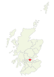
Villages Other villages Allandale · Avonbridge · Binniehill · Blackness · California · Dennyloanhead · Dunmore · Fankerton · Glensburgh · Greenhill · Haggs · Head of Muir · High Bonnybridge · Letham · Limerigg · Longcroft · Muirhouses · Reddingmuirhead · Rumford · Skinflats · South Alloa · Standburn · Stoneywood · Tamfourhill · Torwood · Wallacestone · Westquarter · WhitecrossCategories:- Towns in Falkirk council area
- Central Scotland geography stubs


Wikimedia Foundation. 2010.