- River Axe, Somerset
Geobox River
name = River Axe
native_name =
other_name =
other_name1 =
image_size =
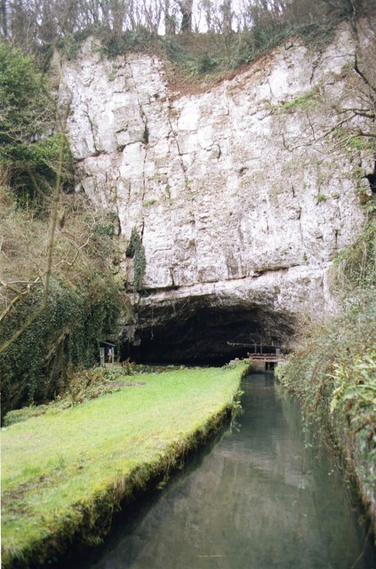
image_caption = The Axe emerging from the limestone atWookey Hole Caves
etymology =
country = England
country1 =
state = Somerset
state_type = County
state1 =
region =
region1 =
district = Somerset Levels
district1 =
city = Wookey
city1 = Henton
landmark = Wookey Hole Caves
landmark1 = Panborough Moor
landmark2 = Knowle Moor
landmark3 = Uphill Cliff
length_imperial =
watershed_imperial =
discharge_location =
discharge_imperial =
discharge_max_imperial =
discharge_min_imperial =
discharge1_location =
discharge1_imperial =
source_name = Mendip Hills
source_location = Wookey Hole Caves
source_district = Mendip
source_region =
source_state = Somerset
source_country = England
source_lat_d = 51
source_lat_m = 13
source_lat_s = 41
source_lat_NS = N
source_long_d = 2
source_long_m = 40
source_long_s = 17
source_long_EW = W
source_elevation_imperial =
source_length_imperial =
mouth_name = Weston Bay
mouth_location = Brean Down
mouth_district = Sedgemoor
mouth_region =
mouth_state = Somerset
mouth_country = England
mouth_lat_d = 51
mouth_lat_m = 19
mouth_lat_s = 15
mouth_lat_NS = N
mouth_long_d = 2
mouth_long_m = 59
mouth_long_s = 34
mouth_long_EW = W
mouth_elevation_imperial =
tributary_left =
tributary_left1 =
tributary_right =
tributary_right1 =
free_name =
free_value =
map_size =
map_caption =The River Axe is a
river in south westEngland . The river rises from the ground atWookey Hole Caves in theMendip Hills inSomerset . The geology of the area islimestone and the water proceeds down to Wookey Hole in a series of underground channels that have eroded through thesoluble limestone.The river was navigable from the
middle ages until 1915, and used for international trade.Geography
From
Wookey Hole village the river flows through aravine and then west through the village ofWookey . At Wookey the River splits into two channels with the ‘Lower River Axe’ running past to the south of the village west towardsHenton and then ontoPanborough Moor where it joins a series of rhynes and drains supplying water to the wetland in the area. The Lower River Axe then runs north along the west most edge ofKnowle Moor whilst the River Axe continues west through the same moor. The two channels meet again on the boundary between Knowle and Panborough Moors.The river continues northwest past
Wedmore Moor and throughOxmoor ,Stoke Moor andMonk Moor . The river passes through the settlement ofLower Weare and on to the south of Loxton. From this point until it passes betweenUphill Cliff andBrean Down , then reaches the coast atWeston Bay , the river forms the northern boundary of the county.The river is a great spot for pike fishing.
History
The lower reaches of the Axe have a history of
navigation from the harbour atUphill through to the settlement of Weare. The current tidal limit of the Axe is the sluice gates atBleadon andBrean Cross .In the Middle Ages overseas trade was carried out from the port of
Rackley , which is now north of the river as the course has been diverted. Rackley is now a farm below Crook Peak and west ofAxbridge , which also had wharves. In the14th century a French ship sailed up the river and by 1388 Thomas Tanner fromWells used Rackley to exportcloth and corn toPortugal , and receivediron and salt in exchange. Later slate was imported through this route and it may have still be possible to trade through Rackley until the act of 1915 authorising the drainage of the Axe and installation of the flood gate at Bleadon. [cite book |last=Toulson |first=Shirley |authorlink= |coauthors= |title=The Mendip Hills: A Threatened Landscape |year=1984 |publisher=Victor Gollancz |location=London |isbn=057503453X ]Bleadon had been a small port, sometimes known as Lympsham Wharf, for many years, with the arrival of the railway in 1841 making this the furthest navigable point. It was last used by the ketch Democrat in 1942.cite book |title=Somerset Harbours |last=Farr |first=Grahame |authorlink= |coauthors= |year=1954 |publisher=Christopher Johnson |location=London |isbn= |pages=65 ]A series of 11
Watermill s were powered by the river but the only one which remains is at Burcott.References
ee also
*
Somerset Levels
Wikimedia Foundation. 2010.