- Mangere
-
Māngere 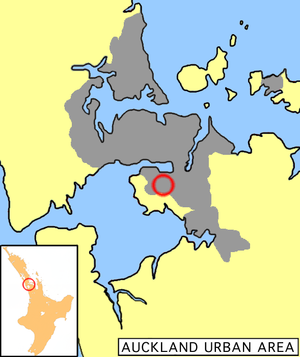
Mangere's location within the Auckland urban areaBasic information Local authority Auckland Council Electoral ward Manukau Local board Māngere-Otahuhu Population 55,266 Postcode(s) 2022 Facilities Airport(s) Auckland Airport Surrounds North Favona East Mangere East South Pukaki Creek Southwest Ihumatao Northwest Mangere Bridge 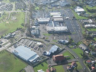 The Māngere Town Centre, showing the very car-centric nature of Auckland's newer suburbs.
Māngere (frequently written Mangere) is one of the larger suburbs in South Auckland, in northern New Zealand.
The suburb is located on flat land at the northeastern shore of the Manukau Harbour, to the northwest of the centre of Manukau city and 15 kilometres south of Auckland city centre. It is an important transportation node for the city, being on one of the two State Highways running south from Auckland (State Highway 20), and also being the location for Auckland Airport, which lies close to the harbour's edge to the south of the suburb.
It has four major sub-areas; Māngere Bridge, Māngere Central and Māngere East, with the fourth, Favona in the east, sometimes counted as part of Māngere as well.
The suburb is named after Mangere Mountain, one of Auckland's largest volcanic cones. The title comes from the Māori words 'hau māngere' meaning lazy winds, after the shelter the mountain provides from the prevailing westerly wind.[citation needed]
Contents
Society
Māngere is often described as a very multicultural area, with Europeans, Maori, Pacific Islanders and Asians and Indians living in the area, often with large families.[1] Houses are a mixture of villas and bungalows, often located on former farms or market gardens developed by the state in the 1940s to 1960s.[1]
Māngere's most famous son is former Prime Minister of New Zealand David Lange, who was the Member of Parliament for Mangere from 1977 until 1996. Another famous local personality is former Heavyweight Boxing Champion David Tua.
Māngere is represented in the New Zealand Parliament by the MP Su'a William Sio, of the Labour Party.[citation needed]
Transport
Further to the east of Māngere, at Otahuhu, the isthmus of Auckland reaches its narrowest point. To supplement this transportation bottleneck, the Māngere Bridge was built to accommodate traffic south from the city, especially that traffic heading for the airport. Construction work on the bridge was the cause of one of New Zealand's longest-running industrial disputes from 1978 until 1980. The bridge was finally completed in 1983, linking Mangere with the Auckland suburb of Onehunga to the north. A motorway through Māngere, linking the southern approach of the bridge with the western edge of Papatoetoe was completed in 1997.[citation needed]
References
- ^ a b "Mangere - Property". The New Zealand Herald. 7 May 2005. http://www.nzherald.co.nz/property/news/article.cfm?c_id=8&objectid=10124196. Retrieved 7 February 2011.
External links
Categories:


Wikimedia Foundation. 2010.