- Hytop, Alabama
Infobox Settlement
official_name = Hytop, Alabama
settlement_type =Town
imagesize =
image_caption =
image_
imagesize =
image_caption =
image_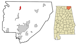
mapsize = 250px
map_caption = Location in Jackson County and the state ofAlabama
mapsize1 =
map_caption1 =
subdivision_type = Country
subdivision_type1 = State
subdivision_type2 = County
subdivision_name =United States
subdivision_name1 =Alabama
subdivision_name2 = Jackson
government_type =
leader_title =
leader_name =
established_date =
area_magnitude =
area_total_km2 = 5.9
area_total_sq_mi = 2.3
area_land_km2 = 5.9
area_land_sq_mi = 2.3
area_water_km2 = 0
area_water_sq_mi = 0
elevation_ft = 1709
elevation_m = 521
population_as_of = 2000
population_footnotes =
population_total = 315
population_metro =
population_density_km2 = 53.4
population_density_sq_mi = 137
timezone = Central (CST)
utc_offset = -6
latd = 34 |latm = 54 |lats = 17 |latNS = N
longd = 86 |longm = 5 |longs = 12 |longEW = W
timezone_DST = CDT
utc_offset_DST = -5
postal_code_type =ZIP code
postal_code = 35768
area_code = 256
blank_name = FIPS code
blank_info = 01-37264
blank1_name = GNIS feature ID
blank1_info = 0156510
footnotes =
website =Hytop is a town in Jackson County,
Alabama ,United States . As of the 2000 census, the population of the town is 315.Geography
Hytop is located at coor dms|34|54|17|N|86|5|12|W|city (34.904816, -86.086634)GR|1.
According to the
U.S. Census Bureau , the town has a total area of 2.3square mile s (5.9km² ), all of it land.Demographics
As of the
census GR|2 of 2000, there were 315 people, 124 households, and 108 families residing in the town. Thepopulation density was 139.5 people per square mile (53.8/km²). There were 139 housing units at an average density of 61.5/sq mi (23.7/km²). The racial makeup of the town was 96.19% White, 1.27% Native American, and 2.54% from two or more races. 0.32% of the population were Hispanic or Latino of any race.There were 124 households out of which 37.9% had children under the age of 18 living with them, 76.6% were married couples living together, 7.3% had a female householder with no husband present, and 12.1% were non-families. 10.5% of all households were made up of individuals and 4.8% had someone living alone who was 65 years of age or older. The average household size was 2.54 and the average family size was 2.72.
In the town the population was spread out with 23.8% under the age of 18, 9.2% from 18 to 24, 34.9% from 25 to 44, 24.4% from 45 to 64, and 7.6% who were 65 years of age or older. The median age was 35 years. For every 100 females there were 99.4 males. For every 100 females age 18 and over, there were 90.5 males.
The median income for a household in the town was $34,306, and the median income for a family was $34,821. Males had a median income of $29,107 versus $19,286 for females. The
per capita income for the town was $15,093. None of the families and none of the population were living below thepoverty line , including no under eighteens and none of those over 64.Radar Site
The
National Weather Service has a radar site in Hytop.References
External links
Wikimedia Foundation. 2010.