- Ofu-Olosega
-
Ofu-Olosega 
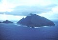
Ofu-Olosega from Space Shuttle.Elevation 639 m (2,096 ft) Prominence 639 m (2,096 ft) Location Location American Samoa Coordinates 14°10′30″S 169°37′05″W / 14.175°S 169.618°WCoordinates: 14°10′30″S 169°37′05″W / 14.175°S 169.618°W Topo map USGS Geology Type Shield volcanoes Last eruption 1866 Ofu and Olosega are parts of a volcanic doublet in the Manu‘a Group of the Samoan Islands—part of American Samoa. The twin islands, formed from shield volcanoes, have a combined length of 6km. They are geographic volcanic remnants separated by the narrow 137m wide Asaga strait, a natural bridge of shallow coral reef. Before 1970, one had to wade between the two islands at low tide; now a single-lane road bridge over the strait connects villages on Ofu island with those on Olosega.
The highest peak on Ofu is Mount Tumutumu (491m, also referred to as Tumu) and the highest elevation on Olosega is Mount Piumafua (629m). The most recent volcanic eruption took place in 1866, 3km south east of Olosega. [1]
Archaeology field work carried out in the 1980s yielded pre-historic evidence including ceramics, adzes, shell and bone which have been significant in furthering understanding of the ancient history of the Samoa Islands and Polynesia. This included samples of red-slipped plainware ceramics that appeared to be in the tradition of Lapita culture. The work, carried out by a team that included Pacific archaeology specialist Patrick Vinton Kirch, focused on a site called To'aga (site AS-13-1), a 2km coastal stretch on the south coast of Ofu. The results showed continuous human habitation of about 3,000 years. [2]
Contents
Ofu
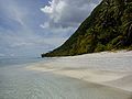
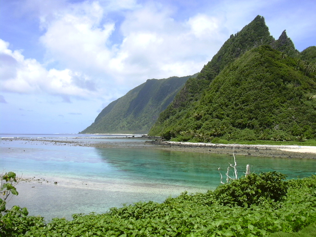
 South shore of Ofu seen from Olosega across the narrow strait that separates them. The sharp peak, an eroding dike complex, is named Sunu‘itao.
Ofu is the western part of the volcanic outcrop of Ofu-Olosega Island. The main village of Ofu is located on the western shore, protected behind an offshore islet (eroded tuff cone) known as Nu'utele. Ofu has a small airport and a boat harbor that serve the population on Ofu and Olosega. Before regular airline service was discontinued in 2009, the flight from Pago Pago took about half an hour.
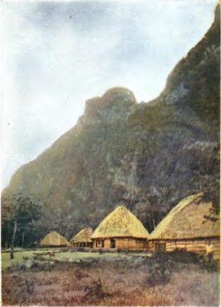
 Olosega village 1896
Most of the southern shore and associated coral reef are part of the National Park of American Samoa. In 2005 the U.S. National Park Service was negotiating with village councils on Olosega to expand the park around that island.
The island forms the Ofu County subdivision of the Manua District. It has a land area of 7.215 km² (2.786 sq mi), and had an official population of 289 persons as of the 2000 census.
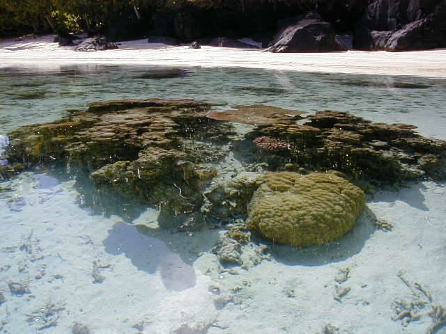
Situated on the south coast of the island is To'aga lagoon which has a high diversity of corals and fishes. The marine site has been part of long term research and study on coral reefs and global climate change.
The island is also home to the Samoa Flying-fox (Pteropus samoensis), a species of bat threatened by habitat loss.
Olosega
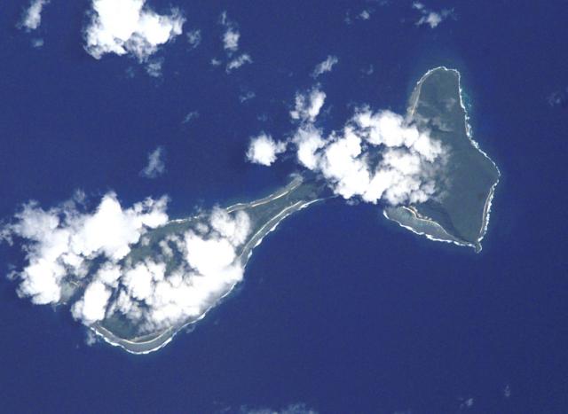
 Aerial view - Olosega village on the right, Ofu on the left. Both islands are connected via a single-lane bridge, crossing the Asaga strait.
Olosega Island is a remnant of the Sili shield volcano, the caldera of which may lie submerged off the north shore.
The volcanic eruption of 1866 was actually 3 km east of Olosega, on a submarine ridge that extends east southeast to nearby Ta‘ū.
The island forms the Olosega County subdivision of the Manua District. It has a land area of 5.163 km² (1.993 sq mi), and had an official population of 216 persons as of the 2000 census.
There are two villages on Olosega: Olosega and Sili. Sili, situated on the northwestern-facing shore, now consists of but one standing inhabited residence after much of the village was destroyed by cyclones (and subsequently abandoned).
Almost all the population of Olosega now reside in Olosega village along the southwestern-facing shore.
Olosega village also has Olosega Elementary School with instruction through grade 9 for children on both islands.
Gallery
- Gallery Ofu-Olosega
-
-

-
-
See also
- Archaeology in Samoa
References
- ^ "Global Volcanism Program, Ofu-Olosega". Smithsonian National Museum of Natural History. http://www.volcano.si.edu/world/volcano.cfm?vnum=0404-01=. Retrieved 13 July, 2010.
- ^ Jason Tyler, Patric V. Kirch, Terry L. Hunt, Lisa Nagaoka (November 1989). "Final Report on Archaeological Investigations at Site AS-13-1, To'aga, Ofu Island, American Samoa". Department of Parks and Recreation, Government of American Samoa. http://docs.google.com/viewer?a=v&q=cache:1D_9fsTUDIsJ:www.ashpo.org/library/7500022-1989.pdf+To'aga+Ofu+island&hl=en&gl=nz&pid=bl&srcid=ADGEESjCo9ETJerADlUmrIpGNa0TlEHS34boZCDbsr7ltIVTvC37O9jMHAVZrYq-NctDWAOpMj3i0WePk5Et760Bo-FDgPKP7JBnKuTN0cNfHT9jGBPGvPv8aJHMW-y1v2eQw461q3jn&sig=AHIEtbRwXePsS3tzSzRZiG_nq671oz_5SQ. Retrieved 13 July, 2010.
External links
- Office of the Governor. 2004. Manu‘a ma Amerika. A brief historical documentary. Manu‘a Centennial. 16 July 1904. 16 July 2004. Office of the Governor, American Samoa Government. 20 p.
- "Ofu-Olosega". Global Volcanism Program, Smithsonian Institution. http://www.volcano.si.edu/world/volcano.cfm?vnum=0404-01=.
- Ofu County and Olosega County, Manu'a District, United States Census Bureau
- National Park Service map of the Manu‘a Islands
- Persistence of Coral Reefs Under Extreme Environmental Stress in American Samoa G. Piniak, C. Birkeland, and G. Garrison (2004). University of Hawaii.
 Territory of American Samoa
Topics Government - Politics
- Former Governors
- Former Lieutenant Governors
- Elections
- Current Governor
Districts Villages - Aasu
- Afao
- Afono
- Agugulu
- Alao
- Alega
- Alofau
- Amaluia
- 'Amanave
- Amaua
- Amouli
- Anua
- 'Aoa
- Aoloau
- Asili
- Atu'u
- Aua
- 'Au'asi
- Aumi
- Aunu'u
- Auto
- Avaio
- Faga'alu
- Faga'itua
- Fagali'i
- Fagamalo
- Faganeanea
- Fagasa
- Fagatogo
- Failolo
- Faleasao
- Faleniu
- Fatumafuti
- Futiga
- 'Ili'ili
- Lauli'i
- Leloaloa
- Leone
- Leusoali'i
- Luma
- Maia
- Malaeimi
- Malaeloa/Aitulagi
- Malaeloa/Ituau
- Maloata
- Mapusagafou
- Masausi
- Masefau
- Matu'u
- Mesepa
- Nu'uuli
- Nua
- Ofu
- Olosega
- Onenoa
- Pagai
- Pago Pago
- Pava'ia'i
- Poloa
- Sa'ilele
- Se'etaga
- Si'ufaga
- Sili
- Taulaga
- Tafuna
- Taputimu
- Tula
- Utulei
- Utumea East
- Utumea West
- Vailoatai
- Vaitogi
- Vatia
Islands - Tutuila
- Aunu'u
- Ta'ū
- Ofu‑Olosega
- Rose Atoll
- Swains Island
Categories:- Islands of American Samoa
- Mountains of American Samoa
- Volcanoes of American Samoa
- Shield volcanoes


Wikimedia Foundation. 2010.