- Milledgeville, Georgia
-
For other uses, see Milledgeville (disambiguation).
Milledgeville, Georgia — City — Location in Baldwin County and the state of Georgia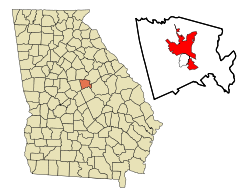
Coordinates: 33°5′16″N 83°14′0″W / 33.08778°N 83.233333°WCoordinates: 33°5′16″N 83°14′0″W / 33.08778°N 83.233333°W Country United States State Georgia County Baldwin Area – Total 20.3 sq mi (52.4 km2) – Land 20 sq mi (51.7 km2) – Water 0.3 sq mi (0.7 km2) Elevation 331 ft (101 m) Population (2000) – Total 18,757 – Density 924/sq mi (358/km2) Time zone Eastern Time (UTC-5) – Summer (DST) EDT (UTC-4) ZIP codes 31059, 31061, 31062 Area code(s) 478 FIPS code 13-51492[1] GNIS feature ID 0332390[2] Milledgeville is a city in and the county seat of Baldwin County[3] in the U.S. state of Georgia. It is northeast of Macon, located just before Eatonton on the way to Athens along U.S. Highway 441, and it is located on the Oconee River. The relatively rapid current of the Oconee here made this an attractive location to build a city. It was the capital of Georgia from 1804 to 1868, notably during the American Civil War. Milledgeville was preceded as the capital city by Louisville, and it was succeeded by Atlanta, the current capital.
The population of the town of Milledgeville was 18,757 at the 2000 census.
Milledgeville is along the route of the under-construction Fall Line Freeway, which will link Milledgeville with Augusta, Macon, Columbus, and other Fall Line cities with long histories from Colonial Georgia.
Milledgeville is the principal city of the Milledgeville Micropolitan Statistical Area, a micropolitan area that covers Baldwin and Hancock counties[4] and had a combined population of 54,776 at the 2000 census.[1]
Contents
History
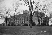 Georgia's second capitol building, 1937.
Milledgeville was named after Georgia governor John Milledge, and was laid out at the start of the 19th century to be the new centrally located capital of the State of Georgia. It served as the state capital from 1804 to 1868 when the Georgia State Legislature moved to Atlanta. In 1803 an act of the Georgia legislature called for the establishment and survey of a town to be named in honor of the current governor, John Milledge. The land immediately west of the Oconee River had just been opened up by the Treaty of Fort Wilkinson (1802), in which the Creek Indians, hard pressed by debts to white traders, agreed to cede part of their ancient land. The restless white population of Georgia was pressing west and south in search of new farmland, and the town of Milledgeville was carved out of the Oconee wilderness to help accommodate their needs. The area was surveyed, and a town plat of 500 acres (2.0 km2) was divided into 84 4-acre (16,000 m2) squares. The survey also included four public squares of 20 acres (81,000 m2) each. In December 1804 Milledgeville was declared by the legislature to be the new capital of Georgia. The new town, modeled after Savannah and Washington, D.C., was located on the edge of the frontier, where the Upper Coastal Plain merges into the Piedmont.
In 1807 fifteen wagons, escorted by troops, left Louisville, the former capital, carrying the treasury and public records of the state. The new statehouse, though unfinished, was able to accommodate the legislators. Over the next thirty years the building was enlarged with a north and south wing. Its pointed arched windows and battlements marked it as America's first public building in the Gothic revival style. Old State Capitol Governor Jared Irwin soon moved into a handsome two-story frame structure known as Government House, on the corner of Clarke and Greene streets. The new capital was a rather crude frontier community with simple clapboard houses, a multitude of inns and taverns, law offices, bordellos, and hostelries. The town attracted several blacksmiths, whitesmiths, apothecaries, dry-goods merchants, and even booksellers. Travelers to the town were generally unimpressed, noting the ill-kept and overcrowded inns, the gambling, the dueling, and the bitter political feuds.
Life in the Antebellum Capital
After 1815 Milledgeville became increasingly prosperous and more respectable. Wealth and power gravitated toward the capital, and the surrounding countryside was caught up in the middle of a cotton boom. Streets were lined with cotton bales waiting to be shipped downriver to Darien. Such skilled architects as John Marlor and Daniel Pratt were designing elegant houses; colossal porticos, cantilevered balconies, pediments adorned with sunbursts, and fanlighted doorways all proclaimed the Milledgeville Federal style of architecture. The major churches built fine new houses of worship on Statehouse Square. The completion in 1817 of the Georgia Penitentiary heralded a new era of penal reform. Public-spirited citizens like Tomlinson Fort (mayor of Milledgeville, 1847–48) promoted better newspapers, learning academies, and banks. In 1837-42 the Georgia Lunatic Asylum (later the Central State Hospital) was developed. Oglethorpe University, where the poet Sidney Lanier was educated, opened its doors in 1838. (The college, forced to close in 1862, was rechartered in 1913, with its campus in Atlanta.) The cotton boom also significantly increased the slave population; by 1828 the town claimed 1,599 inhabitants: 789 free whites, 27 free blacks, and 783 African American slaves. The town market, where slave auctions were held, stood next to the Presbyterian church on Capital Square. Black carpenters, masons, and laborers constructed most of the handsome antebellum structures in Milledgeville. Two events epitomized Milledgeville's status as the political and social center of Georgia in these years. The first was the visit to the capital in 1825 by the Revolutionary War (1775–83) hero the Marquis de Lafayette. The receptions, barbecue, formal dinner, and grand ball for this veteran apostle of liberty seemed to mark Milledgeville's coming of age. The second event was the construction (1836-38/39) of the Governor's Mansion, one of the most important examples of Greek revival architecture in America.
The Civil War and its aftermath
On January 19, 1861, Georgia convention delegates passed the Ordinance of Secession, and the "Republic of Georgia" joined the Confederate States of America, to the accompaniment of wild celebration, bonfires, and illuminations on Milledgeville's Statehouse Square. Three years later, on a bitterly cold November day, Union general William T. Sherman and 30,000 Union troops marched into Milledgeville. When they left a couple of days later, the statehouse had been ransacked; the state arsenal and powder magazine had been destroyed; the penitentiary, the central depot, and the Oconee bridge were burned; and the surrounding countryside was devastated. In 1868, during Reconstruction, the capital was moved to Atlanta—a city emerging as the symbol of the New South as surely as Milledgeville symbolized the Old South.
Milledgeville spent the remaining years of the 19th century trying to survive the loss of the capital. Through the energetic efforts of local leaders, the Middle Georgia Military and Agricultural College (later Georgia Military College) was established in 1879 on Statehouse Square. Where the crumbling remains of the old penitentiary stood, Georgia Normal and Industrial College (later Georgia College & State University) was founded in 1889. In part because of these institutions, as well as Central State Hospital, Milledgeville remained a less provincial town than many of its neighbors.
The Twentieth Century
As the old capital moved into the 20th century, it produced a number of people who would attain national prominence. Among these were the distinguished chemist Charles Herty; epidemiologist Joseph Hill White; Woodrow Wilson's treasury secretary, William Gibbs McAdoo; and Ulrich Bonnell Phillips, a noted historian of the South. The most famous 20th-century Milledgevillians, however, form an unusual trio. In 1910 eighteen-year-old Oliver Hardy, of Laurel and Hardy fame, moved to Milledgeville, where his mother managed the stately old Baldwin Hotel, and stayed for three years. U.S. Congressman Carl Vinson represented his hometown of Milledgeville and central Georgia for fifty years (1914–65). The writer Flannery O'Connor came as a young girl with her family to Milledgeville from Savannah. O'Connor, a 1945 graduate of Georgia State College for Women, did much of her best writing in Milledgeville at her family's farm, Andalusia, which offers public tours. Her critically acclaimed short stories and novels have secured her reputation as a major American writer. In the 1950s the Georgia Power Company completed a dam at Furman Shoals, about five miles (8 km) north of town, creating a huge reservoir called Lake Sinclair. The lake community became an increasingly important part of the town's social and economic identity. In the 1980s and 1990s Milledgeville began to capitalize on its heritage by revitalizing the downtown and historic district. Another attraction, Lockerly Arboretum, offers tours of the facility's botanical gardens as well as educational programs and the Lockerly Heritage Festival each September. By 2000 the population of Milledgeville and Baldwin County combined had grown to 44,700. Community leaders have made concerted efforts to create a more diversified economic base, striving to wean the old capital from its dependence on government institutions such as Central State Hospital and state prisons - a task made more urgent by recent prison closures and job reductions at Central State, caused by tightening state budgets.
Current day industries and occupations
Milledgeville is the location of the Central State Hospital (Georgia's first public psychiatric hospital). See Central State Hospital Website. "Central State," as it is known in Milledgeville and Central Georgia, was founded in 1842.
Educational institutions, colleges and universities
Milledgeville's public school system is governed by the Baldwin County School District. Milledgeville's public schools' website is Baldwin County Schools.
Public elementary schools
- Blandy Hills Elementary School
- Creekside Elementary School
- Eagle Ridge Elementary School
- Midway Elementary School
Public middle school
- Oak Hill Middle School
Public high school
Private schools
- Georgia Military College Prep School (grades 6 - 12)
- John Milledge Academy (grades K-12), JMA's Website
- Sinclair Christian Academy (grades Pre-K - 12)
Schools for higher education
- Georgia Military College
- Georgia College & State University - (commonly known as Georgia College)
- Central Georgia Technical College
Libraries
Milledgeville's public library system is part of the Twin Lakes Library System. Mary Vinson Memorial Library is located downtown. In addition, Georgia College & State University also has a library.
Historic schools
The school system building facilities were revamped during the 1990s and first decade of the 21st century, with all new buildings, including a new Board of Education office. This required relocation and merging of older schools. The concept of a middle school was introduced, whereas previously 6th through 9th grades were housed in separate schools. Closed older schools include:
- Northside Elementary School
- Southside Elementary School
- West End Elementary School
- Harrisburg Elementary School
- Baldwin Middle School (was located in old Baldwin High School)
- Boddie Junior High School (8th and 9th grades)
- Baldwin High School (old location)
- Carver Elementary School (5th and 6th grades / now an alternate school)
- Sallie Davis Middle School (7th grade)
Famous individuals from Milledgeville, Georgia
- Blind Willie McTell, influential blues guitarist, died in Milledgeville.
- Professional baseball players Kevin Brown, Willie Greene, and Rondell White were all born in Milledgeville.
- Vaudeville actor and motion picture comedian Oliver Hardy began his career in Milledgeville.
- Author Flannery O'Connor spent her adolescence and parts of her later life in Milledgeville (at Andalusia) and is buried in Milledgeville's Memory Hill Cemetery.
- Professional football player Earnest Byner was born and raised in Milledgeville.
- Congressman Carl Vinson was from Milledgeville.
- Author Barry Reese was born and raised in Milledgeville.
- Joel Godard, an announcer for the Late Night with Conan O'Brien TV show, was born and raised in Milledgeville.
- Melvin Adams, Jr., better known as Fish Scales from the band Nappy Roots.
- Tennessee Titans cornerback Nick Harper
- Francis Gary Powers, the CIA U-2 pilot shot down over the USSR in 1960 - might have served in the USAF near Milledgeville.
- J.T. Wall from Milledgeville played fullback for the University of GA and had short stints with the Pittsburgh Steelers and the Indianapolis Colts.
- Seattle Seahawks linebacker Leroy Hill played high school football at Baldwin High School in Milledgeville.
- Canada's first train robber Bill Miner is buried in Milledgeville's Memory Hill Cemetery.
- Psychologist Ellis Paul Torrance grew up in Milledgeville and taught at Georgia Military College.
- Race car driver Walt Faulkner lived in Milledgeville from 1920 to 1926.
- Middle linebacker Lucius Sanford was born in Milledgeville. He was All-American at Georgia Tech and later played for the Buffalo Bills and the Cleveland Browns.
- Milledgeville was referenced in the movie, Pretty Woman, starring Julia Roberts. A sign was erected referencing this near the campus of the University in 1999.
Geography
Milledgeville is located at 33°5′16″N 83°14′0″W / 33.08778°N 83.233333°W (33.087755, -83.233401)[5] and is 301 feet (92 m) above sea level.
According to the United States Census Bureau, the city has a total area of 20.2 square miles (52 km2), of which, 20.0 square miles (52 km2) of it is land and 0.3 square miles (0.78 km2) of it (1.33%) is water.
Milledgeville is located on the noted Eastern Fall line of the U.S. The Oconee River flows a half mile east of downtown on its way south to the Altamaha River and then south to the Atlantic Ocean. Lake Sinclair, a man-made lake, is about four miles (6 km) northeast of Milledgeville on the border of Baldwin, Putnam and Hancock County.
Milledgeville is composed of two main districts: a heavily commercialized area extending from a few blocks north of Georgia College & State University to four miles (6 km) north of Milledgeville properly known to locals simply as "441", and the "Downtown" area, encompassing the college, buildings housing city government agencies, various bars and restaurants. This historic area was laid out in 1803, with streets named after other counties in Georgia.
 Milledgeville with Lake Sinclair and dam four miles to the northeast
Demographics
As of the census[1] of 2000, there were 18,757 people, 4,755 households, and 2,643 families residing in the city, although a 2005 study estimates there to be a population of 19,397. The population density was 938.8 people per square mile (362.5/km²). There were 5,356 housing units at an average density of 268.1 per square mile (103.5/km²). The racial makeup of the city was 49.94% White, 47.68% African American, 0.13% Native American, 1.55% Asian, 0.01% Pacific Islander, 0.20% from other races, and 0.50% from two or more races. Hispanic or Latino of any race were 1.23% of the population.
There were 4,755 households out of which 25.9% had children under the age of 18 living with them, 33.6% were married couples living together, 18.7% had a female householder with no husband present, and 44.4% were non-families. 31.7% of all households were made up of individuals and 10.7% had someone living alone who was 65 years of age or older. The average household size was 2.35 and the average family size was 3.04.
In the city the population was spread out with 16.0% under the age of 18, 20.9% from 18 to 24, 32.3% from 25 to 44, 19.6% from 45 to 64, and 11.2% who were 65 years of age or older. The median age was 33 years. For every 100 females there were 166.0 males. For every 100 females age 18 and over, there were 173.2 males.
The median income for a household in the city was $30,484, and the median income for a family was $44,683. Males had a median income of $30,794 versus $23,719 for females. The per capita income for the city was $12,782. About 14.8% of families and 24.0% of the population were below the poverty line, including 28.8% of those under age 18 and 16.3% of those age 65 or over.
Past populations
1900 4,219 1910 4,385 1940 6,779 Points of interest
- Lockerly Arboretum
- Bartram Forest
- Old Governor's Mansion
References
- ^ a b c "American FactFinder". United States Census Bureau. http://factfinder.census.gov. Retrieved 2008-01-31.
- ^ "US Board on Geographic Names". United States Geological Survey. 2007-10-25. http://geonames.usgs.gov. Retrieved 2008-01-31.
- ^ "Find a County". National Association of Counties. http://www.naco.org/Counties/Pages/FindACounty.aspx. Retrieved 2011-06-07.
- ^ MICROPOLITAN STATISTICAL AREAS AND COMPONENTS, Office of Management and Budget, 2007-05-11. Accessed 2008-07-27.
- ^ "US Gazetteer files: 2010, 2000, and 1990". United States Census Bureau. 2011-02-12. http://www.census.gov/geo/www/gazetteer/gazette.html. Retrieved 2011-04-23.
External links
- Official Website: City of Milledgeville Georgia
- Milledgeville GA Convention and Visitors Bureau - Tourism
- Welcome to Milledgeville
- One Stop Shop for Small Business and Entrepreneurs
- Deep Roots Festival
- New Georgia Encyclopedia: Milledgeville
- Milledgeville Historic Newspapers Archive Digital Library of Georgia
Municipalities and communities of Baldwin County, Georgia County seat: MilledgevilleCity Milledgeville
CDP Categories:- Populated places in Baldwin County, Georgia
- Cities in Georgia (U.S. state)
- Former United States state capitals
- Milledgeville micropolitan area
- County seats in Georgia (U.S. state)


Wikimedia Foundation. 2010.