- Maryland Route 35
-
Maryland Route 35
Ellerslie Road 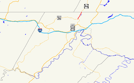
Maryland Route 35 highlighted in redRoute information Maintained by MDSHA Length: 2.37 mi[1] (3.81 km) Existed: 1927 – present Major junctions South end:  MD 36 in Corriganville
North end:  PA 96 in Ellerslie
Location Counties: Allegany Highway system Maryland highway system
Interstate • US • State • Minor • Former • Turnpikes←  MD 34
MD 34MD 36 →Maryland Route 35 (MD 35) is a state highway in the U.S. state of Maryland. Known as Ellerslie Road, the state highway runs 2.37 miles (3.81 km) from MD 36 in Corriganville north to the Pennsylvania state line in Ellerslie, where the highway continues north as Pennsylvania Route 96 (PA 96). MD 35 was constructed in the late 1910s and was one of the original signed state highways in 1927. The state highway runs through the valley of Wills Creek, an important passage for the railroads beginning in the mid 19th century.
Contents
Route description
MD 35 begins at an intersection with MD 36 (Mount Savage Road) in Corriganville. The state highway immediately intersects Kreigbaum Road, which is unsigned MD 831C. After leaving Corriganville, MD 35 heads north as a two-lane road lined with scattered residences. The state highway runs through a narrow valley between Wills Mountain to the east and Little Allegheny Mountain to the west, paralleled by Wills Creek and CSX's Keystone Subdivision. MD 35 passes through Ellerslie, within which the highway crosses a branch of Wills Creek, before reaching its northern terminus at the Pennsylvania state line. The highway continues north as PA 96 (Hyndman Road) toward Hyndman.[1][2]
History
The valley of Wills Creek north of Corriganville has a significant place in railroad history as not only part of the ascent from Cumberland to the Summit of the Alleghenies at Sand Patch but also part of the route between Frostburg and Bedford, Pennsylvania. No less than three different railroads used the part of the valley north of Corriganville in the late 19th century: B&O Railroad, Cumberland and Pennsylvania Railroad, and Western Maryland Railway.[3] The first road built through the valley, the Creek Road, was present by 1898.[3][4] This road was built adjacent to Wills Creek and remains today as Beach View Drive in Corriganville and Schellsburg Road in Ellerslie.[2][4] Between 1917 and 1919 a new road was built by the Maryland State Roads Commission following the present alignment on the hillside above the creek.[5][6][7] In 1927, this road was one of the original signed Maryland state numbered highways. The MD 35 designation originally extended further south along what is today MD 36 to U.S. Route 40 just above the Cumberland Narrows.[8] The southern terminus of MD 35 was rolled back to Corriganville and replaced by MD 36 between 1939 and 1946.[9][10]
Junction list
The entire route is in Allegany County.
Location Mile
[1]Destinations Notes Corriganville 0.00 MD 36 (Mount Savage Road) – Cumberland, Mount SavageSouthern terminus 0.03 Kreigbaum Road Unsigned MD 831C Ellerslie 2.37 PA 96 north (Hyndman Road) – HyndmanNorthern terminus; Pennsylvania state line 1.000 mi = 1.609 km; 1.000 km = 0.621 mi References
- ^ a b c "Highway Location Reference: Allegany County" (PDF). Maryland State Highway Administration. 2009. http://www.marylandroads.com/Location/2009_ALLEGANY.pdf. Retrieved 2010-11-09.
- ^ a b Google, Inc. Google Maps – Maryland Route 35 (Map). Cartography by Google, Inc. http://maps.google.com/maps?f=d&source=s_d&saddr=md-36+and+ellerslie+road+corriganville,+md&daddr=md-35+and+md-96&hl=en&geocode=FY-qXQIdTsBN-ykpRApzLYzKiTEjxiAF4cnZCg%3BFeIfXgId8P5N-ykJ4d9fX4zKiTGQXrz3UKO61Q&mra=ls&sll=39.719203,-78.769569&sspn=0.030171,0.077162&ie=UTF8&ll=39.707979,-78.78253&spn=0.030176,0.077162&t=h&z=14. Retrieved 2010-02-17.
- ^ a b Hansrote, Hazel Groves. "Will's Town". http://www.ourbrickwalls.com/subpage14.html8.html. Retrieved 2010-02-17.
- ^ a b United States Geological Survey. Frostburg, MD quadrangle (Map). 1:48,000. 15 Minute Series (Topographic) (1898 ed.). http://historical.mytopo.com/quad.cfm?quadname=Frostburg&state=MD&series=15. Retrieved 2010-02-17.
- ^ "NBI Structure Number: 100000010068010". National Bridge Inventory. http://nationalbridges.com/nbi_record.php?StateCode=24&struct=100000010068010. Retrieved 2010-11-09.
- ^ Report of the State Roads Commission of Maryland. 1916-1919. Baltimore: Maryland State Roads Commission. January 1920. p. 18. http://www.archive.org/details/annualreportsofs1916mary. Retrieved 2010-02-17.
- ^ Maryland Geological Survey. Map of Maryland: Showing State Road System and State Aid Roads (Map) (1921 ed.).
- ^ Maryland Geological Survey. Map of Maryland: Showing State Road System and State Aid Roads (Map) (1927 ed.).
- ^ Maryland State Roads Commission. General Highway Map: State of Maryland (Map) (1939 ed.).
- ^ Maryland State Roads Commission. Maryland: Official Highway Map (Map) (1946-47 ed.).
External links
Roads in Allegany County, Maryland State highways 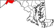
U.S. Highways Interstate Highways Categories:- State highways in Maryland
- Roads in Allegany County, Maryland


Wikimedia Foundation. 2010.