- Crawfordville, Georgia
-
Crawfordville, Georgia — City — Broad Street storefronts in downtown Crawfordville, Georgia, with Taliaferro County Courthouse in the distance Location in Taliaferro County and the state of Georgia
Coordinates: 33°33′17″N 82°53′54″W / 33.55472°N 82.89833°WCoordinates: 33°33′17″N 82°53′54″W / 33.55472°N 82.89833°W Country United States State Georgia County Taliaferro Area – Total 3.1 sq mi (8.1 km2) – Land 3.1 sq mi (8.1 km2) – Water 0 sq mi (0 km2) Elevation 614 ft (187 m) Population (2000) – Total 572 – Density 184.5/sq mi (70.6/km2) Time zone Eastern (EST) (UTC-5) – Summer (DST) EDT (UTC-4) ZIP code 30631 Area code(s) 706 FIPS code 13-20316[1] GNIS feature ID 0313097[2] Crawfordville is a city in Taliaferro County, Georgia, United States. The population was 572 at the 2000 census. The city is the county seat of Taliaferro County[3].
Contents
Geography
Crawfordville is located at 33°33′17″N 82°53′54″W / 33.55472°N 82.89833°W (33.554626, -82.898428)[4]. According to the United States Census Bureau, the city has a total area of 3.1 square miles (8.0 km2), all of it land. The town only has one traffic light located in downtown Crawfordville.
Demographics
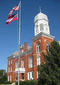 Taliaferro County Courthouse
As of the census[1] of 2000, there were 572 people, 260 households, and 163 families residing in the city. The population density was 182.4 people per square mile (70.3/km²). There were 312 housing units at an average density of 99.5 per square mile (38.4/km²). The racial makeup of the city was 41.43% White, 56.99% African American, 1.05% from other races, and 0.52% from two or more races. Hispanic or Latino of any race were 0.52% of the population.
There were 260 households out of which 25.0% had children under the age of 18 living with them, 32.7% were married couples living together, 26.2% had a female householder with no husband present, and 37.3% were non-families. 35.0% of all households were made up of individuals and 19.6% had someone living alone who was 65 years of age or older. The average household size was 2.20 and the average family size was 2.82.
In the city the population was spread out with 23.1% under the age of 18, 7.5% from 18 to 24, 24.8% from 25 to 44, 23.1% from 45 to 64, and 21.5% who were 65 years of age or older. The median age was 42 years. For every 100 females there were 79.9 males. For every 100 females age 18 and over, there were 71.9 males.
The median income for a household in the city was $19,063, and the median income for a family was $22,386. Males had a median income of $26,705 versus $23,000 for females. The per capita income for the city was $15,103. About 28.8% of families and 29.0% of the population were below the poverty line, including 38.3% of those under age 18 and 20.2% of those age 65 or over.
Education
Taliaferro County School District
The Taliaferro County School District holds grades pre-school to grade twelve, that consists of one charter school offering grades pre-school to grade twelve.[5] The district has 24 full-time teachers and over 280 students.[6]
- Taliaferro County Charter School
Attractions
 Wall mural in Crawfordville
Crawfordville was the home of Alexander H. Stephens, who served as a U.S. Congressman, Governor of Georgia, and most notably as Vice President of the Confederate States of America, 1861–1865. Stephens' home, Liberty Hall, is preserved as a museum and is a part of the A. H. Stephens Historic Park, a Georgia State Park located in Crawfordville.
The movie Sweet Home Alabama with Reese Witherspoon was partially filmed in Crawfordville. It includes the historical Taliaferro County Courthouse in one of the scenes plus many other areas of the county. It also includes a scene with Reese Witherspoon walking down main street.
The movies Coward of the County with Kenny Rogers and Get Low with Robert Duvall were filmed here.
See also
References
- ^ a b "American FactFinder". United States Census Bureau. http://factfinder.census.gov. Retrieved 2008-01-31.
- ^ "US Board on Geographic Names". United States Geological Survey. 2007-10-25. http://geonames.usgs.gov. Retrieved 2008-01-31.
- ^ "Find a County". National Association of Counties. http://www.naco.org/Counties/Pages/FindACounty.aspx. Retrieved 2011-06-07.
- ^ "US Gazetteer files: 2010, 2000, and 1990". United States Census Bureau. 2011-02-12. http://www.census.gov/geo/www/gazetteer/gazette.html. Retrieved 2011-04-23.
- ^ Georgia Board of Education, Retrieved June 26, 2010.
- ^ School Stats, Retrieved June 26, 2010.
External links
Municipalities and communities of Taliaferro County, Georgia County seat: CrawfordvilleCities Crawfordville | Sharon
 Categories:
- Cities in Georgia (U.S. state)
- Populated places in Taliaferro County, Georgia
- County seats in Georgia (U.S. state)
- Populated places in Georgia (U.S. state) with African American majority populations


Wikimedia Foundation. 2010.