- Cloverdale, Western Australia
-
Cloverdale
Perth, Western Australia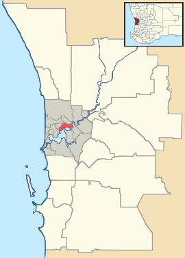
 Cloverdale
Population: 6457 (2006 census)[1] Established: 1954 Postcode: 6105 Area: 3.9 km² (1.5 sq mi) Location: 10 km (6 mi) from Perth LGA: City of Belmont State District: Belmont Federal Division: Swan Suburbs around Cloverdale: Belmont Redcliffe Perth Airport Rivervale Cloverdale Perth Airport Kewdale Kewdale Kewdale Coordinates: 31°57′36″S 115°56′42″E / 31.960°S 115.945°E
Cloverdale is a suburb of Perth, the capital city of Western Australia, and is located 10 kilometres (6 mi) east of Perth's central business district (CBD) in the City of Belmont.
Contents
History
The name was probably derived from "Cloverdale Estate", a subdivision in the area advertised for sale in 1910. It was officially recognised as a suburb name in 1954.[2]
Demography
At the 2006 census, Cloverdale had a population of 6,457. Cloverdale residents had a median age of 37, a year above the State average, and median individual incomes were below-average for the Perth metropolitan area — $414 per week compared with $513 per week. At the 2006 census, 4.37% of residents identified as Indigenous Australians.[1] The suburb had a Decile 3 socioeconomic rating and a SEIFA index of 934.
Geography
Cloverdale is approximately diamond-shaped, and represents the eastern quarter of Belmont's main residential area. It is bounded by Belmont Avenue to the southwest, Sydenham Street to the northwest, Epsom Avenue to the northeast, Tonkin Highway (Route 4) to the east and Leach Highway (Route 7) to the southeast. Abernethy Road (Route 55) runs north-west to south-east through the suburb.[3]
Land Use
 Belmont Forum
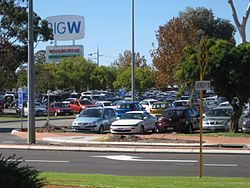
The suburb is almost completely residential. However, its boundaries take in a commercial and civic area on the western side. The main feature here is Belmont Forum, a regional shopping centre with 142 stores which first opened in 1974, and a smaller neighbouring centre Belmont Village which contains a Reading Cinema and the Belmont Tavern. Opposite the centre in Faulkner Park is a civic area containing the City of Belmont's council offices as well as a library, museum and a senior citizens centre. Small shops consisting of no more than two or three retailers are dotted through the suburb.
Cloverdale contains no industrial areas, although Perth Airport is immediately to the east beyond Tonkin Highway, and on the other side of Leach Highway, is the Kewdale industrial area which is one of Perth's largest, which accounts for "Technicians and Trade Workers" being the biggest proportion of Cloverdale's workers in the 2006 ABS Census (18.2%) and workers, labourers and machinery operators and drivers also being high on the list.[1]
Facilities
A number of schools, parks and community facilities are located in Cloverdale.
The Cloverdale and Belmay state primary schools can be found here as well as Notre Dame Primary School, a Catholic school. Another school, Whiteside Primary, used to service the eastern part of the suburb but the school was closed in 1997,[4] and the land sold off by the State Government to build housing. The nearest high school, just to the suburb's northwest, is Belmont City College.
No less than three community centres are located in Cloverdale. These are: the City of Belmont Youth and Family Centre, Miles Park Community Centre, and Forster Hall, as well as a recreation centre near Belmont Oval. Belmont Oval has facilities for lawn bowls and tennis as well as a soccer pitch and dog exercise area. Gerry Archer Athletic Centre, next to the Oval, caters for all athletic events and has a 400 metre grassed running track.[1] It is incorrectly believed by some that Forster Park and Belmont Oval are in Kewdale, but Cloverdale in fact extends southwest to Belmont Avenue. Numerous other small parks, most of them named, are scattered through Cloverdale but they are for the most part simply grassed areas with no distinguishing features.[3]
Transport
The suburb is connected to the rest of Perth's metropolitan area by two routes - Leach Highway, which links to Tonkin Highway, Bayswater/Morley, Forrestfield and the Perth Airport; and Abernethy Road which links to Great Eastern Highway in the direction of Perth CBD.
Cloverdale is served by Transperth buses operated by sWAn Transit. A small bus station at Belmont Forum is host to several bus routes including the 98-99 CircleRoute and various other routes. The 37-39 bus routes travel through Cloverdale along various streets while the 288, 293, 298, 787 and 788 routes service Abernethy Road. The nearest train stations linked by bus to Belmont are Carlisle (288) and Oats Street (98-99).
References
- ^ a b c Australian Bureau of Statistics (25 October 2007). "Cloverdale (State Suburb)". 2006 Census QuickStats. http://www.censusdata.abs.gov.au/ABSNavigation/prenav/LocationSearch?collection=Census&period=2006&areacode=SSC51306&producttype=QuickStats&breadcrumb=PL&action=401. Retrieved 2008-10-05.
- ^ Western Australian Land Information Authority. "History of metropolitan suburb names". http://www.landgate.wa.gov.au/corporate.nsf/web/History+of+metropolitan+suburb+names. Retrieved 21 July 2009.
- ^ a b Department of Land Information. StreetSmart® Perth Street Directory (50 (2009) ed.). West Australian Newspapers Ltd. pp. Map 374. ISBN 978-1-921048-28-9.
- ^ Parliamentary Debates, Western Australian Legislative Assembly, 28 August 2001, pages 3081–3083.
Suburbs of the City of Belmont | Perth | Western Australia Categories:- Suburbs of Perth, Western Australia
- Perth, Western Australia geography stubs


Wikimedia Foundation. 2010.