Chamborigaud

Chamborigaud

Chamborigaud

30 chamborigaud via 2006.jpg
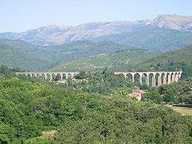
Viaduct of Chamborigaud, with Mont Lozère in the background
Chamborigaud is located in France
{{{alt}}}
Chamborigaud
Administration
Country France
Region Languedoc-Roussillon
Department Gard
Arrondissement Alès
Canton Génolhac
Intercommunality Hautes Cévennes
Mayor Michel Boulat
(2005–2008)
Statistics
Elevation 259–887 m (850–2,910 ft)
(avg. 329 m/1,079 ft)
Land area1 17.86 km2 (6.90 sq mi)
Population2 782  (2008)
 - Density 44 /km2 (110 /sq mi)
INSEE/Postal code 30080/ 30530
1 French Land Register data, which excludes lakes, ponds, glaciers > 1 km² (0.386 sq mi or 247 acres) and river estuaries.
2 Population without double counting: residents of multiple communes (e.g., students and military personnel) only counted once.

Coordinates: 44°18′07″N 3°58′43″E / 44.302°N 3.97861°E / 44.302; 3.97861

Chamborigaud is a commune in the Gard department in southern France.

The village is known for its stunning viaduct, designed by Charles Dombre, the construction of which ended in 1867. Unlike most other bridges of this type, the curve of the Viaduct of Chamborigaud faces upstream.

Contents

Population

Historical population of Chamborigaud
1793 1821 1846 1872 1901 1926 1946 1962 1968 1975
695 923 844 1363 1455 1513 1281 1313 1083 869
1982 1990 1999 2008
872 716 731 782

See also

References

External links


Wikimedia Foundation. 2010.

Игры ⚽ Нужна курсовая?

Look at other dictionaries:

  • Chamborigaud — Chamborigaud …   Deutsch Wikipedia

  • Chamborigaud — Viaducto de Chamb …   Wikipedia Español

  • Chamborigaud — 44° 18′ 08″ N 3° 58′ 43″ E / 44.3022, 3.9786 …   Wikipédia en Français

  • Gare de Chamborigaud — Chamborigaud Localisation Pays France Commune Chamborigaud Adresse Route de Villefort 30530 Chamborigaud Coordonnées géographiques …   Wikipédia en Français

  • Viaduc de Chamborigaud — Pays France Département Gard Localité Chamborigaud …   Wikipédia en Français

  • Viaduc de chamborigaud — Comme son nom l indique, le viaduc de Chamborigaud se trouve en bordure du village cévenol de Chamborigaud dans le Gard. Il traverse la vallée du Luech, c est pourquoi on donne également à cet ouvrage d art le nom de viaduc du Luech. Il fut… …   Wikipédia en Français

  • Luèch — Vorlage:Infobox Fluss/DGWK fehltKoordinaten fehlen! Hilf mit.Vorlage:Infobox Fluss/FLUSSSYSTEM fehltVorlage:Infobox Fluss/EINZUGSGEBIET fehltVorlage:Infobox Fluss/ABFLUSS fehltVorlage:Infobox Fluss/KARTE fehlt Luèch …   Deutsch Wikipedia

  • Gare de Génolhac — Génolhac Localisation Pays France Commune Génolhac Adresse Avenue de la Gare 30450 Génolhac Coordonnées géographiques …   Wikipédia en Français

  • Ligne Des Cévennes — Ligne de Clermont Ferrand à Nîmes Carte de la ligne …   Wikipédia en Français

  • Ligne des Cevennes — Ligne des Cévennes Ligne des Cévennes Ligne de Clermont Ferrand à Nîmes Carte de la ligne …   Wikipédia en Français

Share the article and excerpts

Direct link
Do a right-click on the link above
and select “Copy Link”