- Cleeve Prior
-
Coordinates: 52°08′32″N 1°52′31″W / 52.14236°N 1.875174°W
Cleeve Prior 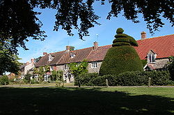
 Cleeve Prior
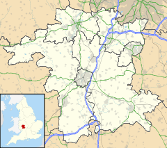
Cleeve Prior shown within WorcestershireDistrict Wychavon Shire county Worcestershire Region West Midlands Country England Sovereign state United Kingdom Police West Mercia Fire Hereford and Worcester Ambulance West Midlands EU Parliament West Midlands List of places: UK • England • Worcestershire Cleeve Prior is a village in the Vale of Evesham Worcestershire, England. It is situated on the cliff (Cleeve) on the Worcestershire/Warwickshire border above the river Avon. There are many picturesque houses made from the local lias stone, including the Kings Arms public house and the 150 year old school. The church is dedicated to St. Andrew, and has 6 bells which are rung for the parish service each Sunday.
Categories:- Villages in Worcestershire
- Worcestershire geography stubs


Wikimedia Foundation. 2010.