Matsumae District, Hokkaidō
- Matsumae District, Hokkaidō
-
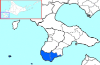
The area of Matsumae District in Oshima Subprefecture.
Matsumae (松前郡, Matsumae-gun?) is a district located in southwestern Oshima Subprefecture, Hokkaidō, Japan.
As of 2004, the district has an estimated population of 16,068 and a density of 33.45 persons per km². The total area is 480.32 km².
Towns
History
- 1869 With the establishment of provinces and Districts in Hokkaidō, Tsugaru District (identical to modern Matsumae Town) and Fukushima District (identical to modern Fukushima Town and Shiriuchi in Kamiiso District) were set up.
- 1871—1872 Placed under Hirosaki Prefecture and Aomori Prefecture.
- 1881 Shiriuchi Village and Shōkokuishi?? Village (小谷石村) (split off from Fukushima Village) transferred to Kamiiso District. The remaining area of Fukushima District and Tsugaru District were merged to form Matsumae District.
- 1897 Matsumae Subprefecture established containing only Matsumae District.
- 1903 Matsumae Subprefecture merged with Hakodate Subprefecture (later renamed Oshima Subprefecture).
Geography
The district is located on the southern end of the Matsumae Peninsula. The district includes the two islands in the Tsugaru Strait, Oshima and Kojima.[1]
References
Categories:
- Districts in Hokkaidō
- Hokkaidō geography stubs
Wikimedia Foundation.
2010.
Look at other dictionaries:
Matsumae — may refer to: People Matsumae clan, a former Japanese clan Manami Matsumae, a freelance composer of video game music Takahiro Matsumae a Japanese daimyo of the Edo period Yoshihiro Matsumae, Japanese samurai of the Sengoku period through early… … Wikipedia
Menashi District, Hokkaidō — The area of Menashi District in Nemuro Subprefecture. Menashi (目梨郡, Menashi gun?) is a district located in Nemur … Wikipedia
Hokkaidō Prefectural Board of Education — Hokkaido Prefectural Board of Education (北海道教育委員会) is a governmental agency that oversees public schools in Hokkaidō in Japan.The board directly oversees high schools in Hokkaidō.High schools [http://www.ipec.hokkaido c.ed.jp/links/gakkou.html]… … Wikipedia
Matsumae, Hokkaidō — This article is about the town in Hokkaidō. There is another town with the same name (松前町) in Ehime, see Masaki, Ehime. More information about the feudal Matsumae Han can be found at Matsumae clan. Matsumae 松前町 Town … … Wikipedia
Ōshima, Hokkaidō — Ōshima Native name: 大島, Ōshima Geography Location East Asia Coordinates … Wikipedia
Fukushima, Hokkaidō — Infobox City Japan Name= Fukushima chō JapaneseName= 福島町 Map Region= Hokkaidō Prefecture= Hokkaidō District= Matsumae gun Area km2= 187.23 PopDate= 2008 Population= 5,549 Density km2= 30.28 Coords= coord|41|28|N|140|15|E|region:JP type:city Tree … Wikipedia
Former Provinces of Hokkaidō — In 1869, the island of Hokkaidō, Japan was divided into 11 provinces and 86 districts. The provinces were dissolved in 1882, and replaced with Hakodate Prefecture, Sapporo Prefecture and Nemuro Prefecture. In 1886, the three prefectures were… … Wikipedia
Assabu, Hokkaidō — Infobox City Japan Name= Assabu JapaneseName= 厚沢部町 Map Region= Hokkaidō Prefecture= Hokkaidō District= Hiyama Area km2= 460.42 PopDate= March, 2008 Population= 4,759 Density km2= 10.55 Coords= coord|41|55|N|140|14|E|region:JP type:city Tree=… … Wikipedia
Hakodate, Hokkaidō — Hakodate 函館 Core city 函館市 From top left … Wikipedia
Kaminokuni, Hokkaidō — nihongo|Kaminokuni|上ノ国町|Kaminokuni chō is a town located in Hiyama District, Hiyama, Hokkaidō, Japan.As of 2008, the town has an estimated population of 6,379 and a density of 12.25 persons per km². The total area is 547.58 km². HistoryStrongman… … Wikipedia

 Hokkaido