- Boxholm, Iowa
Infobox Settlement
official_name = Boxholm, Iowa
settlement_type =City
nickname =
motto =
imagesize =
image_caption =
image_
imagesize =
image_caption =
image_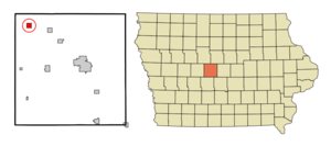
mapsize = 250x200px
map_caption = Location of Boxholm, Iowa
mapsize1 =
map_caption1 =subdivision_type = Country
subdivision_name =
subdivision_type1 = State
subdivision_name1 =
subdivision_type2 = County
subdivision_name2 = Boone
subdivision_type3 = Township
subdivision_name3 = Grant
government_footnotes =
government_type =
leader_title =
leader_name =
leader_title1 =
leader_name1 =
established_title =
established_date =unit_pref = Imperial
area_footnotes =area_magnitude =
area_total_km2 = 2.6
area_land_km2 = 2.6
area_water_km2 = 0.0
area_total_sq_mi = 1.0
area_land_sq_mi = 1.0
area_water_sq_mi = 0.0population_as_of = 2000
population_footnotes =
population_total = 215
population_density_km2 = 81.2
population_density_sq_mi = 210.4timezone = Central (CST)
utc_offset = -6
timezone_DST = CDT
utc_offset_DST = -5
elevation_footnotes =
elevation_m = 349
elevation_ft = 1145
latd = 42 |latm = 10 |lats = 30 |latNS = N
longd = 94 |longm = 6 |longs = 20 |longEW = Wpostal_code_type =
ZIP code
postal_code = 50040
area_code = 515
blank_name = FIPS code
blank_info = 19-07750
blank1_name = GNIS feature ID
blank1_info = 0454780
website =
footnotes =Boxholm is a city in Grant Township, Boone County,
Iowa ,United States . The population was 215 at the 2000 census. It is part of the 'Boone, IowaMicropolitan Statistical Area ', which is a part of the larger 'Ames-Boone, Iowa Combined Statistical Area '.Geography
Boxholm is located at coor dms|42|10|30|N|94|6|20|W|city (42.174905, -94.105523)GR|1.
According to the
United States Census Bureau , the city has a total area of 1.0square mile s (2.6km² ), all of it land.Demographics
As of the
census GR|2 of 2000, there were 215 people, 103 households, and 63 families residing in the city. Thepopulation density was 210.4 people per square mile (81.4/km²). There were 108 housing units at an average density of 105.7/sq mi (40.9/km²). The racial makeup of the city was 100.00% White. Hispanic or Latino of any race were 0.47% of the population.There were 103 households out of which 23.3% had children under the age of 18 living with them, 50.5% were married couples living together, 9.7% had a female householder with no husband present, and 37.9% were non-families. 35.9% of all households were made up of individuals and 18.4% had someone living alone who was 65 years of age or older. The average household size was 2.09 and the average family size was 2.67.
In the city the population was spread out with 21.9% under the age of 18, 2.3% from 18 to 24, 26.0% from 25 to 44, 27.4% from 45 to 64, and 22.3% who were 65 years of age or older. The median age was 45 years. For every 100 females there were 93.7 males. For every 100 females age 18 and over, there were 86.7 males.
The median income for a household in the city was $37,083, and the median income for a family was $38,750. Males had a median income of $33,333 versus $22,000 for females. The
per capita income for the city was $18,503. About 7.8% of families and 7.5% of the population were below thepoverty line , including 9.5% of those under the age of eighteen and 14.8% of those sixty five or over.ee also
*
Boxholm References
External links
Wikimedia Foundation. 2010.