- Duleek
-
Duleek
Damhliag— Town — Location in Ireland
 Duleek
Coordinates: 53°39′18″N 6°25′00″W / 53.6551°N 6.4166°WCoordinates: 53°39′18″N 6°25′00″W / 53.6551°N 6.4166°W Country Ireland Province Leinster County County Meath Population (2006) - Urban 3,236 Time zone WET (UTC+0) - Summer (DST) IST (WEST) (UTC-1) Irish Grid Reference O048687 Duleek (Irish: Damhliag, meaning "stone house or church[1]") is a town in County Meath, Ireland, close to the Louth border. Duleek takes is name from the Irish word daimh liag, meaning house of stones and referring to an early stone-built church, St Cianan’s Church, the ruins of which are still visible in Duleek today. The Duleek Heritage Trail has been conceived as a series of stepping stones through the village and its long and varied history.
In a poll carried out in March 2007 by national radio station Newstalk 106, Duleek was voted Ireland's friendliest town.
Contents
History
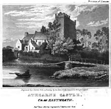 Athcarne Castle, Co. of Eastmeath, 1820
Duleek began as an early Christian monastic settlement. St Patrick established a bishopric here about 450 AD, which he placed in the care of St Cianan on November 24, 489. The place was sacked several times by the Norsemen between 830 and 1149 and was also pillaged by the Normans in 1171. In April 1014 the bodies of Brian Ború and his son lay in state in Duleek on their way to Armagh.
The 12th century saw the reconstitution of the original monastery as St Mary's Abbey.
The first Norman Overlord of Meath, Hugh de Lacy, established a manor and constructed a motte castle at Duleek. About 1180 he granted St Cianan's Church, together with certain lands, to the Augustinians. The churchyard of the now disused Church of Ireland church occupies part of the site of the early monastery. The village’s four crosses and the lime tree on the village green are reminders of Duleek’s links to the struggle between William and James and to wider European unrest at the time of Louis XIV of France. One of the crosses, the Wayward Cross, was however erected in 1601 by Jane Dowdall in memory of her husband, William Bathe of Athcarne Castle outside the town.[2] During World War II, or The Emergency, German bombers accidentally struck the village on January 1, 1941; minor damage was caused and there were no casualties.
Transport
Duleek railway station was opened on 1 August 1850, but was finally closed on 1 June 1958.[3] Trains still operate through the old station between Drogheda and Tara Mines.
See also
External links
References
- ^ Irish Local Names Explained by P.W. Joyce
- ^ Duleek Heritage Trail, Meath Tourism - Ireland, Accommodation, Holidays, Vacations, Golf, Fishing, Castles, Maps
- ^ "Duleek station". Railscot - Irish Railways. http://www.railscot.co.uk/Ireland/Irish_railways.pdf. Retrieved 2007-09-05.
Categories:- Towns and villages in County Meath
- Ireland geography stubs


Wikimedia Foundation. 2010.