- Murray Morgan Bridge
-
City Waterway Bridge
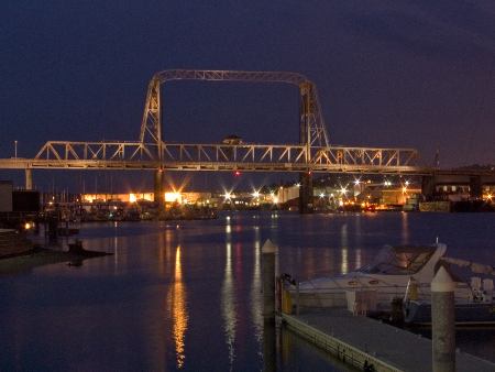
 Murray Morgan bridge from the Thea Foss Waterway
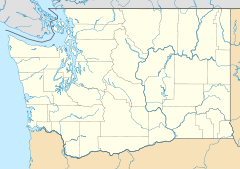

Location: Tacoma, Washington Coordinates: 47°15′14.45″N 122°25′56.57″W / 47.2540139°N 122.4323806°WCoordinates: 47°15′14.45″N 122°25′56.57″W / 47.2540139°N 122.4323806°W Built: 1911 Architect: Waddell & Harrington; International Contract Co. Architectural style: Other Governing body: State MPS: Historic Bridges/Tunnels in Washington State TR NRHP Reference#: 82004278
[1]Added to NRHP: July 16, 1982 The Murray Morgan Bridge, also known as the 11th Street bridge or City Waterway bridge, is a lift bridge in Tacoma, Washington. It was built in 1913 to replace an 1894 swing-span bridge.[2] The bridge connects downtown with the tideflats, it spans the Thea Foss Waterway, originally known as the City Waterway. Designed by famous bridge designers Waddell & Harrington, the bridge has some unusual features: higher above the water than most lift bridges, construction on a variable grade and an overhead span designed to carry a water pipe.[3] The bridge structure also contained a wooden road which connected what is now Cliff Street with Dock Street. According to the Department of Transportation, the towers are 207' 1 3/4" (63.14 m) above the water, with the road deck 60' above the water level at zero tide. It was modified and updated in 1957 and was used to route State Route 509 through the tideflats. The bridge was bypassed in the late 1990s when State Route 509 was routed around the edge of the tideflats. While WSDOT wanted to tear down the bridge, the City of Tacoma convinced the state to transfer ownership to the City.[4] The City of Tacoma currently has a plan to rehabilitate the bridge, however this process remains largely unfunded.[5] In the past, the bridge has been heavily used by commuters and emergency services in connecting the Port of Tacoma with downtown Tacoma.[6][7]
Contents
Name
Originally known as the 11th Street Bridge, it was renamed May 21, 1997, to honor Tacoma-born Murray Morgan (1916–2000), the best-known Pacific Northwest historian of his generation, and author of "Skid Road", a history of Seattle, Washington. Morgan was a bridge tender on the bridge during the 1950s. In fact, he wrote most of "Skid Road" during quiet periods on the job.[8][9]
Closure
The bridge was officially closed on October 23, 2007 due to "life safety concerns".[10][11] It remains to be seen if the bridge will ever reopen. The bridge was probably closed in the wake of the I-35W Mississippi River bridge collapse of 2007. The bridge remains open to pedestrian and bicycle traffic.[12] Currently WSDOT plans to turn ownership back to the City of Tacoma as the bridge no longer serves a state-owned freeway, but rather city streets. The City of Tacoma is considering possibilities to rehabilitate the bridge with existing funding.[13] The bridge was returned to limited pedestrian and bicycle service on March 31, 2010.
Damage
On December 15, 2010 it was discovered that thieves broke into the mechanical room and took wiring from the control panel used to raise the bridge for ship traffic on the Foss Waterway. The city is looking for an interim method of operating the span with the estimated cost of replacing the equipment set at $250,000[14]
 360° panorama of downtown Tacoma as viewed from the Murray Morgan Bridge.
References
- ^ "National Register Information System". National Register of Historic Places. National Park Service. 2007-01-23. http://nrhp.focus.nps.gov/natreg/docs/All_Data.html.
- ^ Long, Priscilla (2003-09-06). "the Free Online Encyclopedia of Washington State History". HistoryLink.org. http://www.historylink.org/index.cfm?DisplayPage=output.cfm&File_Id=5543. Retrieved 2011-08-20.
- ^ "WSDOT: City Waterway Bridge". Wsdot.wa.gov. 2006-05-18. http://www.wsdot.wa.gov/Environment/CulRes/bridges.htm#CityWaterway. Retrieved 2011-08-20.
- ^ "Tacoma News Tribune:Broken Promises on Bridge, November 12th, 2007". Thenewstribune.com. http://www.thenewstribune.com/news/local/story/201629.html. Retrieved 2011-08-20.
- ^ http://www.cityoftacoma.org/Page.aspx?nid=919
- ^ http://www.cityoftacoma.org/Page.aspx?hid=13996
- ^ [1][dead link]
- ^ Long, Priscilla (2003-05-16). "the Free Online Encyclopedia of Washington State History". HistoryLink.org. http://www.historylink.org/index.cfm?DisplayPage=output.cfm&File_Id=5458. Retrieved 2011-08-20.
- ^ Lange, Greg (2002-11-29). "the Free Online Encyclopedia of Washington State History". HistoryLink.org. http://www.historylink.org/index.cfm?DisplayPage=output.cfm&file_id=5021. Retrieved 2011-08-20.
- ^ State closes Murray Morgan bridge Tacoma News Tribune
- ^ Safety Concerns Close Murray Morgan Bridge WSDOT Press Release
- ^ [2] WSDOT's Murray Morgan Bridge Information Home Page
- ^ [3] City Manager's weekly report to the City Council, June 25, 2009.
- ^ [4] Wire thieves disable Tacoma bridge lift span AP
External links
- Historylink - Tacoma's Eleventh Street (City Waterway) Bridge opens on February 15, 1913.
- Historylink - Washington renames Tacoma's Eleventh Street Bridge as Murray Morgan Bridge on May 21, 1997.
- Puget Sound Transportation Projects - Murray Morgan Bridge
Map Coordinates: 47°15′14″N 122°26′00″W / 47.253995°N 122.43327°W
U.S. National Register of Historic Places Topics Lists by states Alabama • Alaska • Arizona • Arkansas • California • Colorado • Connecticut • Delaware • Florida • Georgia • Hawaii • Idaho • Illinois • Indiana • Iowa • Kansas • Kentucky • Louisiana • Maine • Maryland • Massachusetts • Michigan • Minnesota • Mississippi • Missouri • Montana • Nebraska • Nevada • New Hampshire • New Jersey • New Mexico • New York • North Carolina • North Dakota • Ohio • Oklahoma • Oregon • Pennsylvania • Rhode Island • South Carolina • South Dakota • Tennessee • Texas • Utah • Vermont • Virginia • Washington • West Virginia • Wisconsin • WyomingLists by territories Lists by associated states Other Categories:- Bridges in Tacoma, Washington
- Bridges completed in 1911
- Bridges on the National Register of Historic Places in Washington (state)
- National Register of Historic Places in Tacoma, Washington
- Vertical lift bridges
- Towers in Washington (state)
- Road bridges in Washington (state)


Wikimedia Foundation. 2010.