- Mazeppa, Minnesota
-
Mazeppa, Minnesota — City — Location of Mazeppa, Minnesota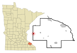
Coordinates: 44°16′21″N 92°32′39″W / 44.2725°N 92.54417°W Country United States State Minnesota County Wabasha Area – Total 1.0 sq mi (2.5 km2) – Land 1.0 sq mi (2.5 km2) – Water 0.0 sq mi (0.0 km2) Elevation 955 ft (291 m) Population (2010)[1] – Total 842 – Density 795.7/sq mi (307.2/km2) Time zone Central (CST) (UTC-6) – Summer (DST) CDT (UTC-5) ZIP code 55956 Area code(s) 507 FIPS code 27-41282[2] GNIS feature ID 0647648[3] Mazeppa is a city in Wabasha County, Minnesota, United States, along the North Fork of the Zumbro River. The population was 842 at the 2010 census.[1]
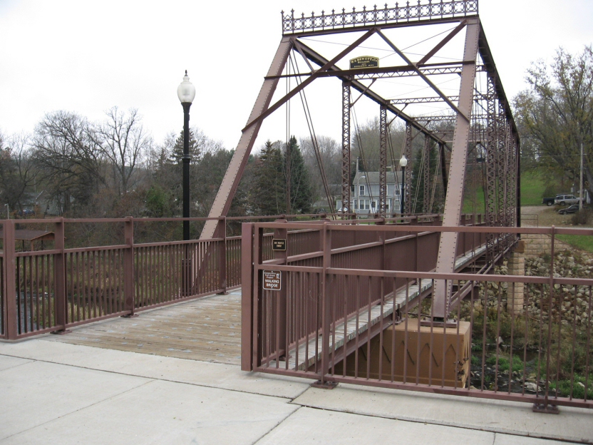
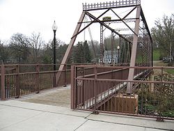 The Walnut Street Walking Bridge crosses the Zumbro River in Mazeppa and is on the National Register of Historic Places.
Contents
Geography
According to the United States Census Bureau, the city has a total area of 1.0 square mile (2.6 km2), all of it land.
Minnesota State Highway 60 serves as a main route in the community.
Demographics
As of the census[2] of 2000, there were 778 people, 312 households, and 214 families residing in the city. The population density was 795.7 people per square mile (306.5/km²). There were 335 housing units at an average density of 342.6 per square mile (132.0/km²). The racial makeup of the city was 97.69% White, 0.39% African American, 1.29% Native American, 0.13% from other races, and 0.51% from two or more races. Hispanic or Latino of any race were 0.77% of the population.
There were 312 households out of which 36.2% had children under the age of 18 living with them, 55.8% were married couples living together, 8.7% had a female householder with no husband present, and 31.4% were non-families. 28.5% of all households were made up of individuals and 12.8% had someone living alone who was 65 years of age or older. The average household size was 2.49 and the average family size was 3.06.
In the city the population was spread out with 29.2% under the age of 18, 7.6% from 18 to 24, 28.8% from 25 to 44, 20.2% from 45 to 64, and 14.3% who were 65 years of age or older. The median age was 36 years. For every 100 females there were 99.0 males. For every 100 females age 18 and over, there were 98.9 males.
The median income for a household in the city was $36,375, and the median income for a family was $46,250. Males had a median income of $30,208 versus $21,607 for females. The per capita income for the city was $17,509. About 5.7% of families and 7.4% of the population were below the poverty line, including 8.7% of those under age 18 and 20.5% of those age 65 or over.
Education
High school students attend the Zumbrota-Mazeppa High School jointly with students from the nearby town of Zumbrota.
References
- ^ a b "2010 Census Redistricting Data (Public Law 94-171) Summary File". American FactFinder. United States Census Bureau. http://factfinder2.census.gov/faces/tableservices/jsf/pages/productview.xhtml?pid=DEC_10_PL_GCTPL2.ST13&prodType=table. Retrieved 27 April 2011.
- ^ a b "American FactFinder". United States Census Bureau. http://factfinder.census.gov. Retrieved 2008-01-31.
- ^ "US Board on Geographic Names". United States Geological Survey. 2007-10-25. http://geonames.usgs.gov. Retrieved 2008-01-31.
External links
Municipalities and communities of Wabasha County, Minnesota Cities Bellechester‡ | Elgin | Hammond | Kellogg | Lake City‡ | Mazeppa | Millville | Minneiska‡ | Plainview | Wabasha | Zumbro Falls

Townships Unincorporated
communitiesCamp Lacupolis | Maple Springs | Reads Landing | South Troy | Weaver
Footnotes ‡This populated place also has portions in an adjacent county or counties
Categories:- Cities in Minnesota
- Populated places in Wabasha County, Minnesota
- Zumbro River
- Rochester, Minnesota metropolitan area


Wikimedia Foundation. 2010.