- Dundarrach, North Carolina
-
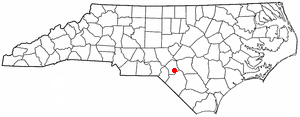
Dundarrach, North Carolina — CDP — Location of Dundarrach, North Carolina
Coordinates: 34°55′12″N 79°9′34″W / 34.92°N 79.15944°WCoordinates: 34°55′12″N 79°9′34″W / 34.92°N 79.15944°W Country United States State North Carolina County Hoke Area – Total 1.6 sq mi (4.0 km2) – Land 1.6 sq mi (4.0 km2) – Water 0.0 sq mi (0.0 km2) Elevation 223 ft (68 m) Population (2000) – Total 62 – Density 39.7/sq mi (15.3/km2) Time zone Eastern (EST) (UTC-5) – Summer (DST) EDT (UTC-4) FIPS code 37-18300[1] GNIS feature ID 0984428[2] Dundarrach is a census-designated place (CDP) in Hoke County, North Carolina, United States. The population was 62 at the 2000 census.
Geography
Dundarrach is located at 34°55′12″N 79°9′34″W / 34.92°N 79.15944°W (34.920124, -79.159371)[3].
According to the United States Census Bureau, the CDP has a total area of 1.6 square miles (4.1 km2), all of it land.
Demographics
As of the census[1] of 2000, there were 62 people, 25 households, and 19 families residing in the CDP. The population density was 39.7 people per square mile (15.3/km²). There were 31 housing units at an average density of 19.8/sq mi (7.7/km²). The racial makeup of the CDP was 69.35% White, 11.29% African American and 19.35% Native American. Hispanic or Latino of any race were 9.68% of the population.
There were 25 households out of which 32.0% had children under the age of 18 living with them, 48.0% were married couples living together, 28.0% had a female householder with no husband present, and 24.0% were non-families. 20.0% of all households were made up of individuals and 12.0% had someone living alone who was 65 years of age or older. The average household size was 2.48 and the average family size was 2.74.
In the CDP the population was spread out with 22.6% under the age of 18, 4.8% from 18 to 24, 35.5% from 25 to 44, 16.1% from 45 to 64, and 21.0% who were 65 years of age or older. The median age was 38 years. For every 100 females there were 100.0 males. For every 100 females age 18 and over, there were 84.6 males.
The median income for a household in the CDP was $4,659, and the median income for a family was $16,250. Males had a median income of $0 versus $0 for females. The per capita income for the CDP was $6,975. There were no families and 39.3% of the population living below the poverty line, including no under eighteens and 57.9% of those over 64.
References
- ^ a b "American FactFinder". United States Census Bureau. http://factfinder.census.gov. Retrieved 2008-01-31.
- ^ "US Board on Geographic Names". United States Geological Survey. 2007-10-25. http://geonames.usgs.gov. Retrieved 2008-01-31.
- ^ "US Gazetteer files: 2010, 2000, and 1990". United States Census Bureau. 2011-02-12. http://www.census.gov/geo/www/gazetteer/gazette.html. Retrieved 2011-04-23.
Municipalities and communities of Hoke County, North Carolina City 
Town CDPs Ashley Heights | Bowmore | Dundarrach | Five Points | Rockfish | Silver City
Military base Footnotes ‡This populated place also has portions in an adjacent county or counties
Categories:- Populated places in Hoke County, North Carolina
- Census-designated places in North Carolina
- Fayetteville, North Carolina metropolitan area

Wikimedia Foundation. 2010.