- Chiredzi District
-
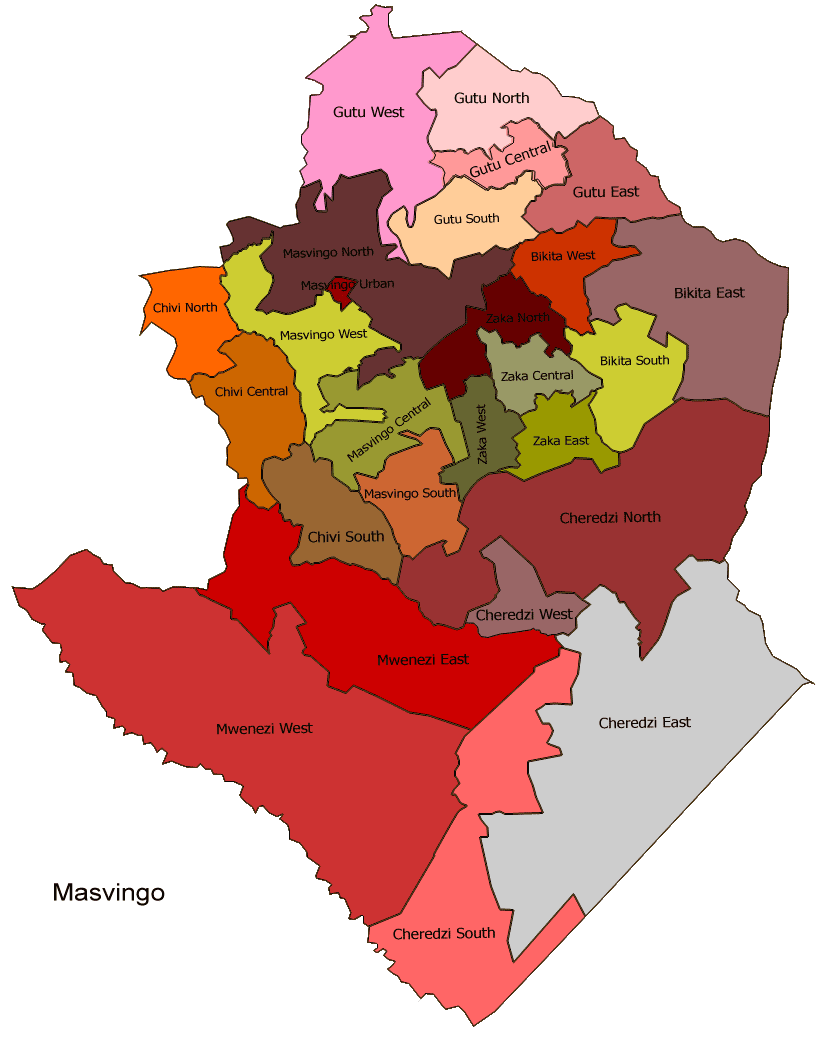
Chiredzi District — District — A baobab tree in Gonarezhou national park, which is found in the district. Masvingo constituency seats for the 2008, showing the division of Chiredzi (District)
Coordinates: 18°55′S 29°49′E / 18.917°S 29.817°ECoordinates: 18°55′S 29°49′E / 18.917°S 29.817°E Country Zimbabwe Province Masvingo District Chiredzi Established late 19th century Population (2002) – Total 233 000 estimated (UN) Time zone CET (UTC+1) – Summer (DST) CEST (UTC+1) - This article is about the district. For the town, see Chiredzi
Chiredzi District is found in south-east Zimbabwe in Masvingo Province. The district is the major center of sugar production in the country. Hippo Valley Hospital, found in the district, is one of a numbers of center for HIV/AIDS treatment in the province.[1]
The district is famous for hosting Hippo Valley Estate and the nearby Mkwasine Estate both of which specialize in sugar cane and citrus fruit production.
Contents
Geography
A large chunk of the district is found in region V, although there are some parts that lie in region IV. In the Zimbabwean sense, areas in region five a characterized by aridity and uncertain rainfall patterns. Many parts of the district was unfit for agriculture, hence in 1972 they well left out to form Gonarezhou national park. In terms of surface area, Chiredzi is one of the largest districts in the country with over 95% of its area taken up by Gonarenzou and other conservancies like Malilangwe. With the arid climate, most people grow sorghum, one of the crops which is drought tolerant and requires minimal rains to grow to maturity. The red soils found in the district are also suitable for sugarcane, and prior to the land invasions of 2000, the district was a center for sugar production for the whole country.[2]
Population
The district is sparsely populated. The Shanganes for a majority, with everybody in the district speaking Shangane, a dialect that is related to both Zulu and Ndebele.
Government and politics
General elections 2008
Like Gutu, Chiredzi district has been divided into four sectors for the general elections of 2008. Candidates from both the MDC-T and the MDC-M, and from ZANU-PF and independents will compete for the four constituency seats available and the winners will go on to represent the district in Zimbabwe's new House of Assembly.[dated info]
For the Chiredzi East east, Mafamu Dennis (PAFA), Sithole Abraham (Zanu-PF), Chingombe Samson (MDC Mtambara), Chiromo Walter (MDC Tsvangirai) are registered to contest the seat, while Tafamba Olivia (PAFA), Ndava Ronald (Zanu-PF), and Mutambu John (MDC Tsvangirai) will contest Chiredzi north. Baloyi Alois (Zanu-PF), Zanamwe Nehemiah (MDC), Chirove Joseph (MDC Tsvangirai) are vying for Chiredzi south while Musareva Ernest (PAFA), Samson Aliginia (Zanu-PF), Mungwadzi Godfrey (Independent), Mashiri Robson (MDC Mutambara), and nickrd) will fight it out for Cheridzi west.[3]
See also
- Chiredzi
- Gonarenzou National Park
References
Masvingo Province Business Centres Towns & Cities Districts Noteworthy Places Subdivisions of Zimbabwe Provinces Districts Beitbridge · Bikita · Bindura · Binga · Bubi · Buhera · Bulawayo · Bulilimamangwe · Chegutu · Chikomba · Chimanimani · Chipinge · Chiredzi · Chirumhanzu · Chivi · Gokwe North · Gokwe South · Goromonzi · Guruve · Gutu · Gwanda · Gweru · Harare · Hurungwe · Hwange · Hwedza · Insiza · Kadoma · Kariba · Kwekwe · Lupane · Makonde · Makoni · Marondera · Masvingo · Matobo · Mazowe · Mberengwa · Mount Darwin · Mudzi · Mukumbura · Murehwa · Mutare · Mutasa · Mutoko · Muzarabani · Mwenezi · Nkayi · Nyanga · Rushinga · Seke · Shamva · Shurugwi · Tsholotsho · Umguza · Umzingwane · Uzumba-Maramba-Pfungwe · Wedza · Zaka · Zvimba · ZvishavaneWards Largest cities Categories:- Chiredzi District
- Districts of Masvingo Province
- Zimbabwe geography stubs

Wikimedia Foundation. 2010.