- Coal Grove, Ohio
-
Coal Grove, Ohio — Village — Location of Coal Grove, Ohio
Coordinates: 38°30′1″N 82°38′45″W / 38.50028°N 82.64583°WCoordinates: 38°30′1″N 82°38′45″W / 38.50028°N 82.64583°W Country United States State Ohio County Lawrence Area – Total 2.1 sq mi (5.5 km2) – Land 2.0 sq mi (5.1 km2) – Water 0.2 sq mi (0.4 km2) Elevation[1] 577 ft (176 m) Population (2000) – Total 2,027 – Density 1,028.1/sq mi (397.0/km2) Time zone Eastern (EST) (UTC-5) – Summer (DST) EDT (UTC-4) ZIP code 45638 Area code(s) 740 FIPS code 39-16378[2] GNIS feature ID 1075593[1] Coal Grove is a village in Lawrence County, Ohio, United States, along the Ohio River. The population was 2,027 at the 2000 census. The 2006 Census estimate reports a population increase to 2,087 residents [1]. It borders the city of Ironton and lies across the Ohio River from Ashland, Kentucky. It is linked to Ashland by the Ben Williamson Memorial Bridge and Simeon Willis Memorial Bridge.
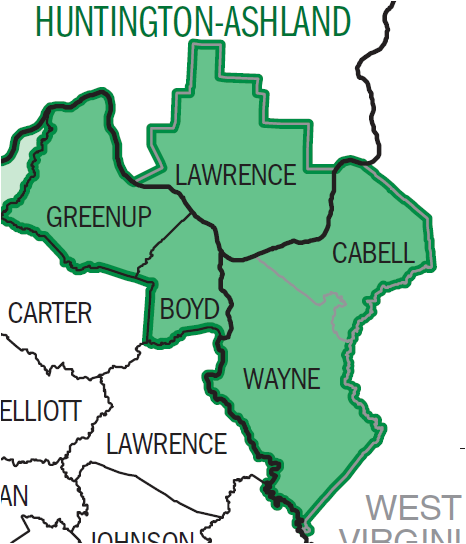
Coal Grove is a part of the Huntington-Ashland, WV-KY-OH, Metropolitan Statistical Area (MSA). As of the 2000 census, the MSA had a population of 288,649.
Contents
Geography
Coal Grove is located at 38°30′1″N 82°38′45″W / 38.50028°N 82.64583°W (38.500240, -82.645926).[3]
According to the United States Census Bureau, the village has a total area of 2.1 square miles (5.4 km2), of which, 2.0 square miles (5.2 km2) of it is land and 0.2 square miles (0.52 km2) of it (7.94%) is water.
Demographics
As of the census[2] of 2000, there were 2,027 people, 810 households, and 562 families residing in the village. The population density was 1,028.1 people per square mile (397.3/km²). There were 877 housing units at an average density of 444.8 per square mile (171.9/km²). The racial makeup of the village was 98.77% White, 0.10% African American, 0.35% Native American, 0.05% from other races, and 0.74% from two or more races. Hispanic or Latino of any race were 0.69% of the population.
There were 810 households out of which 30.2% had children under the age of 18 living with them, 51.5% were married couples living together, 13.7% had a female householder with no husband present, and 30.6% were non-families. 27.9% of all households were made up of individuals and 14.6% had someone living alone who was 65 years of age or older. The average household size was 2.43 and the average family size was 2.90.
In the village the population was spread out with 23.6% under the age of 18, 9.4% from 18 to 24, 25.1% from 25 to 44, 24.3% from 45 to 64, and 17.6% who were 65 years of age or older. The median age was 39 years. For every 100 females there were 89.6 males. For every 100 females age 18 and over, there were 82.1 males.
The median income for a household in the village was $26,101, and the median income for a family was $33,000. Males had a median income of $29,886 versus $21,563 for females. The per capita income for the village was $14,332. About 15.0% of families and 18.6% of the population were below the poverty line, including 29.3% of those under age 18 and 9.2% of those age 65 or over.
Government and politics
The village is managed by a mayor and a village council. The mayor of Coal Grove is Larry Mcdaniel.
Education
Coal Grove is the home to the Dawson-Bryant Local School District. The district maintains one high school and middle school in the village itself and one elementary school in Deering. The schools are named after two local men, Homer Dawson and Curtis Bryant, who fought in the First World War. Located near Deering is a one-room schoolhouse that used to serve all grades. This building has the distinction of being one of the oldest structures in the county.[citation needed] It is also thought to have been visited by at least two presidents but this is not confirmed.[citation needed]
See also
References
- ^ a b "US Board on Geographic Names". United States Geological Survey. 2007-10-25. http://geonames.usgs.gov. Retrieved 2008-01-31.
- ^ a b "American FactFinder". United States Census Bureau. http://factfinder.census.gov. Retrieved 2008-01-31.
- ^ "US Gazetteer files: 2010, 2000, and 1990". United States Census Bureau. 2011-02-12. http://www.census.gov/geo/www/gazetteer/gazette.html. Retrieved 2011-04-23.
Municipalities and communities of Lawrence County, Ohio City 
Villages Athalia | Chesapeake | Coal Grove | Hanging Rock | Proctorville | South Point
Townships CDP Unincorporated
communitiesEtna | Kitts Hill | Pedro | Rock Camp | Scottown | Waterloo | Willow Wood
Huntington–Ashland, WV–KY–OH, Metropolitan Statistical Area Principal cities 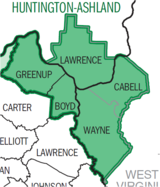
Municipalities with population
over 5,000Municipalities with population
1,000-5,000Barboursville • Burlington • Catlettsburg • Ceredo • Coal Grove • Culloden CDP • Greenup • Kenova • Milton • Raceland • Russell • South Point • South Shore • Wayne • Westwood CDP • Worthington • WurtlandMunicipalities with population
under 1,000West Virginia counties Kentucky counties Ohio counties Categories:- Villages in Ohio
- Populated places in Lawrence County, Ohio
- Huntington–Ashland metropolitan area


Wikimedia Foundation. 2010.